- Home
- Prelims
- Mains
- Current Affairs
- Study Materials
- Test Series
 EDITORIALS & ARTICLES
ABC of Earthquakes
An earthquake is what happens when two blocks of the earth suddenly slip past one another. The surface where they slip is called the fault or fault plane. The location below the earth’s surface where the earthquake starts is called the hypocenter, and the location directly above it on the surface of the earth is called the epicenter.
Sometimes an earthquake has foreshocks. These are smaller earthquakes that happen in the same place as the larger earthquake that follows. Scientists can’t tell that an earthquake is a foreshock until the larger earthquake happens. The largest, main earthquake is called the mainshock. Mainshocks always have aftershocks that follow. These are smaller earthquakes that occur afterwards in the same place as the mainshock. Depending on the size of the mainshock, aftershocks can continue for weeks, months, and even years after the mainshock!
What causes Earthquakes?
- As we know, the earth’s outermost surface, crust, is fragmented into tectonic plates.
- The edges of the plates are called plate boundaries, which are made up of faults.
- The tectonic plates constantly move at a slow pace, sliding past one another and bumping into each other.
- As the edges of the plates are quite rough, they get stuck with one another while the rest of the plate keeps moving.
- Earthquake occurs when the plate has moved far enough and the edges unstick on one of the faults.
- The location below the earth’s surface where the earthquake starts is called the hypocenter, and the location directly above it on the surface of the earth is called the epicentre.
Vibrations inside the earth
Earthquakes are vibrations inside the Earth that follow the release of energy that has built up inside rocks. Rocks fracturing, volcanoes erupting, and man made explosions can all release the energy stored in the rocks creating seismic waves.
Faults are cracks in the crust
Faults are cracks in the crust of the Earth where the earth is moving apart, coming together, or slipping past each other. Each of these movements on the surface of the earth cause earthquakes.
Determining the location of an earthquake
Scientists use difference in the the arrival times of the two sets of seismic waves to determine the location of an earthquake. Using this data scientists can deter what causes earthquakes in the region.
Earthquake Zones
Tracking location of earthquakes
Scientists began tracking and pinpointing the location of earthquakes using data from seismograms. A seismogram is a recording of the ground motion of an earthquake by a seismograph. They found that earthquakes occurred in earthquake zones that outlined the tectonic plates on Earth.
Formation of mountain ranges
When two continental plates collide they form mountain ranges between the plates as the rocks are compressed. The Himalayan Mountains are an example of the Indian Plate and Eurasian Plate colliding.
Pacific Ocean is shrinking
Around the Pacific Ocean are subduction zones where an ocean plate is forced beneath a continental plate or a younger oceanic plate. As the Pacific Plate subducts beneath other tectonic plates it is growing smaller.
The Atlantic Ocean is increasing in size
The Atlantic Ocean is a divergent boundary where new oceanic crust is forming. The Atlantic Ocean is increasing in size as the Pacific Plate decreases in size. All of these plate movements create earthquakes zones at plate boundaries.
P waves & S waves
All earthquakes produce P waves and S waves. P waves compress and expand the rock particles as they travel through solids, liquids and gases. P waves are the first to arrive at reporting stations letting seismologists know an earthquake has occurred. Shortly after the P waves have arrived seismographs record the arrival of S waves.
- P waves
P waves are primary waves that are produced by all earthquakes large and small. Rock breaking along a fault line release the energy stored in the rocks when the rocks break due to pressure inside the Earth creating primary waves that are also known as compression waves. - S waves
S waves are also always produced during an earthquake. S waves are transverse waves that move forward in a back and forth motion are also called secondary waves. These waves arrive at reporting stations after P waves. S waves and P waves are known as body waves because they travel through the body of the Earth. - P waves expand and contract rock particles
The focus of an earthquake is the point where the rocks break apart at the start of an earthquake. These waves travel in all directions away from the focus of an earthquake. P waves are energy waves that cause rock particles inside the earth to expand and contract like the slinky in the picture as they move through the body of the Earth. - P waves traveling through the body of the Earth
Compression waves expand rock particles ahead of the waves and compress them as they travel away. They can also compress and expand air. When compression waves reach the Earth''s surface they create a noise often associated with earthquakes. Sometimes people hear a sharp thud while others think the sound is loud and like wind blowing through leaves in a tree. People sleeping are sometimes awakened by the noise as the earthquake arrives at their home. - Seismographs
Seismographs are instruments that record earthquake waves when they arrive at reporting stations on the surface of the Earth. Lines on seismograms show the motion in the Earth as the waves travel to and from the reporting station. - P waves are primary waves
Primary waves are P waves that arrive at recording stations first. They are the fastest waves produced by an earthquake. - S waves are secondary waves
S waves are produced by all earthquakes. S waves arrive a short time after P waves at recording stations. Scientists use the travel time of the two waves to determine the distance the between the focus of an earthquake and the reporting station. Scientists use at least three reporting stations to calculate the exact point where the earthquake originated. - Discovering the boundary between the crust and mantle of the Earth
P waves move through solids, liquids and gases. S waves only travel only through solids. The earthquake waves are deflected when the composition of rocks within the Earth change. The scientist who discovered the boundary between the crust and mantle discovered the boundary when he noticed that earthquake waves were deflected at different depths underground. The Moho boundary is deeper under the continents than under the oceanic crust. - Beno Gutenberg discovers Earth''s core
Beno Gutenberg discovered the liquid outer core while studying body waves. He found that S waves were stopped at a depth of 2900 km beneath the surface of the Earth. This is the boundary between the mantle and the liquid outer core. - Inge Lehmann discovers Earth''s inner core
Inge Lehmann in 1936 studying earthquake waves that originated in Japan. She found that P waves sped up inside the core of the Earth for a distance before they slowed down. She used the travel times of these waves through the center of the Earth to prove the existence of a solid inner core of the Earth.
|
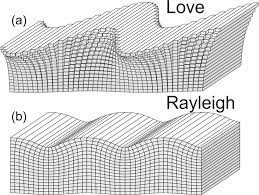
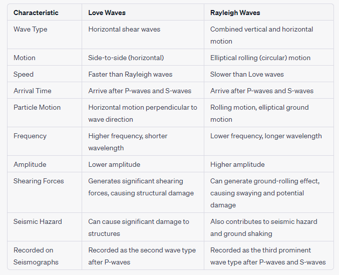
Love Waves Love waves are a type of horizontally polarized shear wave. They move with a side-to-side motion, similar to the motion of a snake or a wriggling rope. Love waves are the fastest surface waves and typically arrive after the initial body waves (P-waves and S-waves) during an earthquake. They propagate through the Earth’s crust in a horizontal, side-to-side motion that is perpendicular to the direction of wave travel.
Rayleigh waves, also known as ground roll or rolling waves, are a type of surface wave that combines both vertical and horizontal motion. They create an elliptical, rolling motion as they travel along the Earth’s surface. This rolling motion is similar to the motion you might observe in ocean waves.
|
Origin of an Earthquake
- Where is the earthquake focus? The focus of an earthquake is the point where the rocks start to fracture. It is the origin of the earthquake.
- The epicenter is the point on land directly above the focus.
- Hypocenter of an earthquake
- The focus is also called the hypocenter of an earthquake. The vibrating waves travel away from the focus of the earthquake in all directions. The waves can be so powerful they will reach all parts of the Earth and cause it to vibrate like a turning fork.
- Epicenter of an earthquake
- Directly above the focus on the Earth''s surface is the earthquake epicenter. Earthquake waves start at the focus and travel outward in all directions. Earthquake waves DO NOT originate at the epicenter.
- Richter scale used for shallow-focus earthquakes
Shallow-focus earthquakes occur between 0 and 40 miles deep. Shallow-focus earthquakes are much more common than deep-focus earthquakes. Crustal plates moving against each other produce most of the shallow-focus earthquakes here on Earth. These earthquakes are generally smaller and scientists use the Richter scale when measuring these earthquakes. - Energy released by shallow focus earthquakes
Shallow-focus earthquakes are much more dangerous than deep-focus earthquakes. They release 75% of all the energy produced by earthquakes each year. They are crustal earthquakes that are smaller than deep-focus earthquakes. - Deep-Focus Earthquakes Use Moment Magnitude Scale
- Deep-focus earthquakes occur 180 miles or more below the Earth''s surface. These earthquakes occur in island arc or deep ocean trenches where one plate is slipping over another in subduction zones. Great earthquakes where one plate is slipping over another plate in a subduction zone trigger deep-focus earthquakes. They are the largest earthquakes and scientists use the moment magnitude scale to measure them.
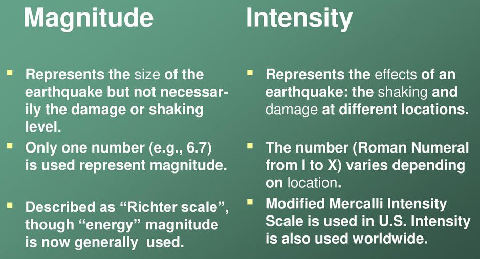
- Richter Scale and the Mercalli Scale - The Richter Scale and the Mercalli Scale are both used to measure the intensity of earthquakes, but they do so in different ways. The Richter Scale is a quantitative scale that measures the magnitude of an earthquake based on the seismic waves recorded by seismographs. It is a logarithmic scale, meaning each whole number increase on the scale represents a tenfold increase in measured amplitude and roughly 31.6 times more energy release. On the other hand, the Mercalli Scale is a qualitative scale that measures the intensity of an earthquake based on observed effects and damage. It takes into account people''s perceptions and reactions, as well as the physical damage to buildings and other structures. The Mercalli Scale ranges from I (not felt) to XII (total destruction).

Seismic Waves and Structure of Earth
Earthquakes create seismic waves that travel through the Earth. By analyzing these seismic waves, seismologists can explore the Earth's deep interior. This fact sheet uses data from the 1994 magnitude 6.9 earthquake near Northridge, California to illustrate both this process and Earth's interior structure. The cutaway of Earth on the left shows the paths seismic waves traveled following the quake. The ground motion caused by the seismic waves is shown at the right (seismograms recorded at various locations around the world).
Seismologists study shock, or seismic, waves as they travel through the Earth’s interior. These waves originate from natural sources like earthquakes, and from artificial sources like man-made explosions. Knowing how the waves behave as they move through different materials enables us to learn about the layers that make up the Earth. Seismic waves tell us that the Earth’s interior consists of a series of concentric shells, with a thin outer crust, a mantle, a liquid outer core, and a solid inner core.
- Seismic waves can tell us a lot about the internal structure of the Earth because these waves travel at different speeds in different materials.
- Reflection causes P and S waves to rebound whereas refraction makes waves move in different directions.
- The variations in the direction of these waves are inferred with the help of their record on seismograph.
- Change in densities greatly varies the wave velocity. By observing the changes in velocity, the density of the earth as a whole can be estimated. By the observing the changes in direction of the waves (emergence of shadow zones), different layers can be identified.
- For both kinds of waves, the speed at which the wave travels also depends on the properties of the material through which it is traveling.
- Scientists are able to learn about Earth’s internal structure by measuring the arrival of seismic waves at stations around the world.
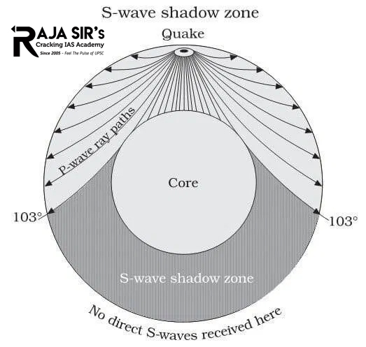
- For example, we know that Earth’s outer core is liquid because s-waves are not able to pass through it; when an earthquake occurs there is a “shadow zone” on the opposite side of the earth where no s-waves arrive.
- Similarly, we know that the earth has a solid inner core because some p-waves are reflected off the boundary between the inner core and the outer core.
- By measuring the time it takes for seismic waves to travel along many different paths through the earth, we can figure out the velocity structure of the earth.
- Abrupt changes in velocity with depth correspond to boundaries between different layers of the Earth composed of different materials.
Shadow Zone of P-waves and S-waves
- S-waves do not travel through liquids (they are attenuated).
- The entire zone beyond 103° does not receive S-waves, and hence this zone is identified as the shadow zone of S-waves. This observation led to the discovery of the liquid outer core.
- The shadow zone of P-waves appears as a band around the earth between 103° and 142° away from the epicentre.
- This is because P-waves are refracted when they pass through the transition between the semisolid mantle and the liquid outer core.
- However, the seismographs located beyond 142° from the epicentre, record the arrival of P-waves, but not that of S-waves. This gives clues about the solid inner core.
- Thus, a zone between 103° and 142° from epicentre was identified as the shadow zone for both the types of waves.

The structure of Earth’s deep interior cannot be studied directly. But geologists use seismic (earthquake) waves to determine the depths of layers of molten and semi-molten material within Earth. Geologists are now using these records to establish the structure of Earth’s interior.


 Latest News

 General Studies