
Recently, six people were killed and several others injured during an alleged clash between the Assam Police and a mob in an area bordering the West Karbi Anglong district of Assam and Mukroh village in Meghalaya’s West Jaintia Hills.
- The killings come ahead of the second phase of talks between the two statesto resolve their boundary dispute.
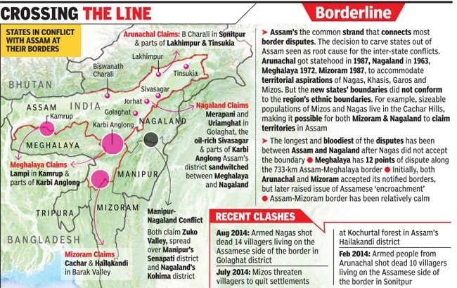
Assam-Meghalaya Border Dispute
- Assam and Meghalayahave a longstanding dispute in 12 stretches of their 884-km shared border.
- The Assam-Meghalaya border dispute are the areas ofUpper Tarabari, Gazang reserve forest, Hahim, Langpih, Borduar, Boklapara, Nongwah, Matamur, Khanapara-Pilangkata, Deshdemoreah Block I and Block II, Khanduli and Retacherra.
- During British rule, undivided Assam included present-day Nagaland, Arunachal Pradesh, Meghalaya and Mizoram.
- Meghalaya was carved out in 1972,its boundaries demarcated as per the Assam Reorganisation (Meghalaya) Act of 1969, but has held a different interpretation of the border since.
- In 2011, the Meghalaya government had identified 12 areas of difference with Assam,spread over approximately 2,700 sq km.
- Major Point of Concern:
- A major point of contention between Assam and Meghalaya is the district of Langpih in West Garo Hillsbordering the Kamrup district of Assam.
- Langpih was part of the Kamrup district during the British colonial periodbut post-Independence, it became part of the Garo Hills and Meghalaya.
- Assam considers it to bepart of the Mikir Hills in Assam.
- Meghalaya has questioned Blocks I and II of the Mikir Hills-now Karbi Anglong region - being part of Assam.
- Meghalaya says these were parts of erstwhile United Khasiand Jaintia Hills
- Attempts to Resolve Dispute:
- In 1985, under the Assam chief minister and Meghalaya chief minister, an official committee was constitutedunder the former Chief Justice of India Y V Chandrachud.
- However, a solution was not found.
- Both state governments identified six out of 12 disputed areas for resolutionin the first phase:
- Three areas contested between West Khasi Hills districtin Meghalaya and Kamrup in Assam, two between RiBhoi in Meghalaya and Kamrup-Metro, and one between East Jaintia Hills in Meghalaya and Cachar in Assam.
- After a series of meetings and visits by teams to the disputed areas, both sides submitted reportsbased on five mutually agreed principles:
- Historical perspective, ethnicity of local population, contiguity with boundary, peoples’ will and administrative convenience.
- A final set of recommendations were made jointly:
- Out of 36.79 sq km of disputed area taken up for settlement in the first phase, Assam would get full control of 18.46 sq kmand Meghalaya of 18.33 sq km.
- In March 2022, a Memorandum of Understanding was signed based on these recommendations.
- The second round of discussions for the remaining six phases is to commence by the end November 2022.
- In 1985, under the Assam chief minister and Meghalaya chief minister, an official committee was constitutedunder the former Chief Justice of India Y V Chandrachud.
 Suggestions to Resolve the Dispute
- Boundary disputes between the states can be settled by using satellite mapping of the actual border locations.
- Reviving the Inter-state councilcan be an option for resolution of an Inter-state dispute.
- Under Article 263 of the Constitution,the Inter-state council is expected to inquire and advise on disputes, discuss subjects common to all states and make recommendations for better policy coordination.
- Similarly,Zonal councils need to be revived to discuss the matters of common concern to states in each zone—matters relating to social and economic planning, border disputes, inter-state transport, etc.
- India is the epitome of unity in diversity. However, in order to strengthen this unity furthermore, both the centre and state governments, need to imbibe the ethos of cooperative federalism.