- Home
- Prelims
- Mains
- Current Affairs
- Study Materials
- Test Series
 EDITORIALS & ARTICLES
News Information Bureau | 11th August 2020
PM Modi HIGHLIGHTS: Ultra fast 4G in Andaman by Airtel; undersea telecom cable to boost digital connectivity - Submarine Cable Connectivity (CANI)
Prime Minister Narendra Modi has launched the submarine Optical Fibre Cable (OFC) connecting Andaman and Nicobar Islands to the mainland. The foundation stone for this project was laid by the Prime Minister on 30th December 2018 at Port Blair.
 Events led to the events of August 1942
 Geothermal spring

- The laying of cables for about 2300 kilometres (from Chennai to Andaman and Nicobar Islands) under the sea (at a cost of Rs.1,224 crores) from as surveying in the deep sea, maintaining the quality of the cable and laying of the cable with specialised vessels is not an easy task.
- The project also had to overcome challenges such as high waves, storms and monsoons and the tough times owing to Corona Pandemic.
- Optical fibre is the technology associated with data transmission using light pulses travelling along with a long fibre which is usually made of plastic or glass.
- Metal wires are preferred for transmission in optical fibre communication as signals travel with fewer damages.
- Optical fibres arealso unaffected by electromagnetic interference. The fibre optical cable uses the application of total internal reflection of light.
- The fibres are designed such that they facilitate the propagation of light along with the optical fibre depending on the requirement of power and distance of transmission.
- Single-mode fibre is used for long-distance transmission, while multimode fibre is used for shorter distances.
- Optical fibres are economical and cost effective; thin and non-inflammable; consumes less power; less signal degradation, and are flexible and lightweight.
- Submarine Cable will help A&N in getting cheaper & better connectivity and all the benefits of Digital India, especially in improving online education, tele-medicine, banking system, online trading and in boosting tourism.
- A Sunspot is an area on the Sun that appears dark on the surface and is relatively cooler than surrounding parts.
- These spots, some as large as 50,000 km in diameter, are the visible markers of the Sun’s magnetic field, which forms a blanket that protects the solar system from harmful cosmic radiation.
- On the photosphere – the outer surface of the Sun which radiates heat and light – Sunspots are the areas where the star’s magnetic field is the strongest; around 2,500 times more than the Earth’s magnetic field.
- Most Sunspots appear in groups that have their own magnetic field, whose polarity reverses during every solar cycle, which takes around 11 years. In every such cycle, the number of Sunspots increases and decreases.
- The current solar cycle, which began in 2008, is in its ‘solar minimum’ phase, when the number of Sunspots and solar flares is at a routine low.
- Because Sunspots have high magnetic pressures, the atmospheric pressure in the surrounding photosphere reduces, inhibiting the flow of hot gases from inside the Sun to the surface.
- Due to this, the temperatures of Sunspots are thousands of degrees lower than the surrounding photosphere, which has a temperature of 5,800 degrees Kelvin. Sunspots temperatures are around 3,800 degrees Kelvin.
- Because they stop the convective flow of heat and light, Sunspots appear dark. They typically consist of a dark region called the ‘umbra’, which is surrounded by a lighter region called the ‘penumbra’.
- When a Sunspot reaches up to 50,000 km in diameter, it may release a huge amount of energy that can lead to solar flares. The flares are caused by explosions that are triggered due to the twisting, crossing or reorganising of magnetic field lines near Sunspots.
- At times, solar flares are accompanied by Coronal Mass Ejections (CME) – large bubbles of radiation and particles emitted by the Sun that explode into space at high speed. CMEs can trigger intense light in the sky on Earth, called auroras.
- The solar flare explosion’s energy can be equivalent to a trillion ‘Little boy’ atomic bombs dropped on Hiroshima and Nagasaki in 1945.
- Solar flares can have a major effect on radio communications, Global Positioning Systems (GPS) connectivity, power grids, and satellites.
 Events led to the events of August 1942
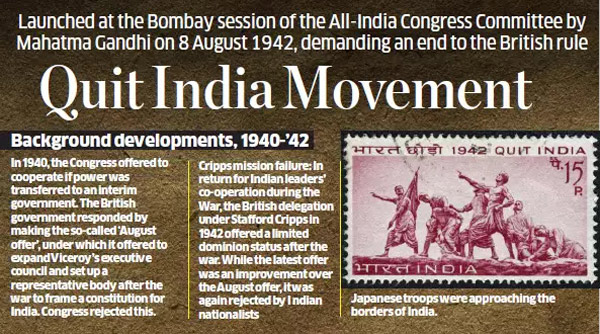
- While factors leading to such a movement had been building up, matters came to a head with the failure of the Cripps Mission.
- In March 1942, a mission led by Sir Stafford Cripps arrived in India to meet leaders of the Congress and the Muslim League. The idea was to secure India’s whole-hearted support in the war, in return for self-governance.
- However, despite the promise of “the earliest possible realisation of self-government in India”, the offer Cripps made was of dominion status, and not freedom. Also, there was a provision of the partition of India, which was not acceptable to the Congress.
- The failure of the Cripps Mission made Mahatma Gandhi realise that freedom would be had only by fighting tooth and nail for it. The Congress decided to launch a mass civil disobedience. At the Working Committee meeting in Wardha in July 1942, it was decided the time had come for the movement to move into an active phase.
- On August 8, Bapu addressed the people from Mumbai’s Gowalia Tank maidan. “Here is a mantra, a short one, that I give you. Imprint it on your hearts, so that in every breath you give expression to it. The mantra is: ‘Do or Die’. We shall either free India or die trying; we shall not live to see the perpetuation of our slavery,” Gandhi said. Aruna Asaf Ali hoisted the Tricolour on the ground, and the Quit India movement had been officially announced.
- By August 9, Gandhi and all other senior Congress leaders had been jailed. Bapu was kept at the Aga Khan Palace in Pune, and later in the Yerawada jail. It was during this time that Kasturba Gandhi died at the Aga Khan Palace.
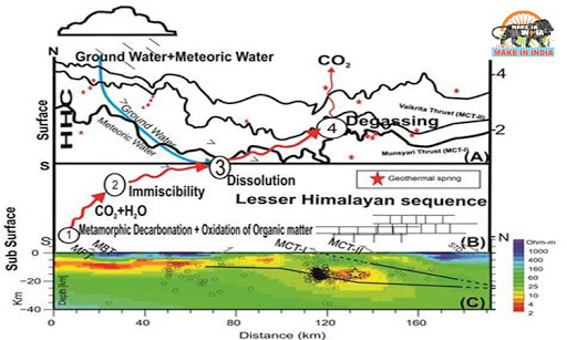
- Himalaya hosts about 600 geothermal springs having varied temperature and chemical conditions. Their role in regional and global climate, as well as the process of tectonic driven gas emission, needs to be considered while estimating emissions to the carbon cycle and thereby to global warming.
- The Himalayan geothermal springs which cover about 10,000 square km in the Garhwal region of Himalaya, show a significant discharge of Carbon dioxide (CO2) rich water. The estimated carbon dioxide degassing (removal of dissolved gases from liquids, especially water or aqueous solutions) flux is nearly 7.2 ×10⁶ mol/year to the atmosphere.
- The study published in the scientific journal Environmental Science and Pollution Research suggested that CO2 in these thermal springs are sourced from metamorphic decarbonation of carbonate rocks present deep in the Himalayan core along with magmatism and oxidation of graphite.
- Most of the geothermal water is dominated by evaporation followed by weathering of silicate rocks. Isotopic analyses further point towards a meteoric source for geothermal water.
 Geothermal spring
- Water that percolates into the porous rock is subjected to intense heat by the underlying hard rock which is in contact with hot magma in the mantle or the lower part of the crust.
- Under the influence of intense heat, the water in the capillaries and narrow roots in the porous rock undergoes intense expansion and gets converted to steamresulting in high pressure.
- When this steam or water at high pressure finds a path to the surface through narrow vents and weak zones, appear at the surface as geysers and hot water springs, also known as geothermal springs.
- Among the key points on the table was evolving a procedure to solve differences on technical aspects governing the construction of the Ratle run-of-the-river (RoR) project on the Chenab in the Kishtwar district of Jammu and Kashmir.
- India has called for the appointment of a ‘neutral’ party’ while Pakistan favours a Court of Arbitration to agree upon a final resolution on the design parameters of this hydropower project.
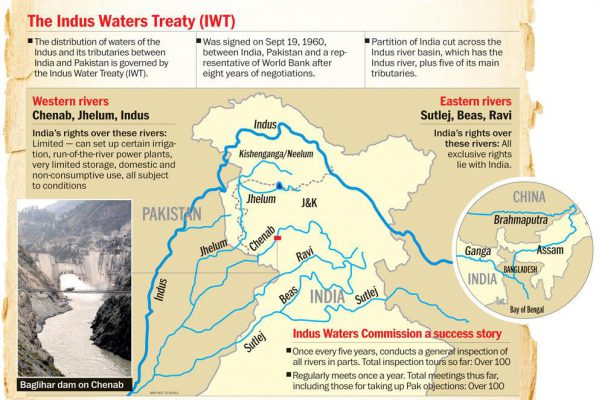
- According to the terms of the IWT, India has the right to build RoR projects on the three ‘western’ rivers — the Chenab, Jhelum and Indus — provided it does so without substantially impeding water flow in Pakistan downstream.
- Pakistan believes that the project’s current design does pose a serious impediment and has told the World Bank that it wants a Court of Arbitration (CoA) set up to decide on the issue. India says this is only a technical issue and mutually solvable. It has agreed to a ‘neutral party’ since a CoA potentially could stall any construction on all Indus projects.

- The treaty was signed in 1960 by then Prime Minister Jawaharlal Nehru and then Pakistan President Ayub Khan.
- The six rivers of the Indus basin originate in Tibet and flow across the Himalayan ranges to end in the Arabian Sea south of Karachi.
- The three western rivers (Jhelum, Chenab and Indus) were allocated to Pakistanwhile India was given control over the three eastern rivers (Ravi, Beas and Sutlej).
- While India could use the western rivers for consumption purpose, restrictions were placed on building of storage systems. The treaty states that aside of certain specific cases, no storage and irrigation systems can be built by India on the western rivers.
- It was brokered by the World Bank. The Treaty also provides arbitration mechanism to solve disputes amicably. A Permanent Indus Commission was set up as a bilateral commission to implement and manage the Treaty. The Commission solves disputes arising over water sharing.


 Latest News
 General Studies