Theory of isostasy

Isostasy is a concept in that the lighter crust is floating on top of the denser underlying mantle. It is used to explain how varied topographic heights on the Earth''s surface can occur. Isostatic equilibrium is the ideal state in which the crust and mantle would settle if no disturbing factors existed. Processes that disturb isostasy include the waxing and waning of ice sheets, erosion, sedimentation, and extrusive volcanism. The physical properties of the lithosphere are impacted by how the mantle and crust respond to these perturbations. Understanding the dynamics of isostasy helps us comprehend more complex processes such as mountain development, sedimentary basin formation, continent break-up, and the formation of new ocean basins.

  • The theory of isostasy is a fundamental principle that explains the buoyant behavior of the Earth''s lithosphere as it floats upon the more fluid asthenosphere (a part of the upper mantle) below.
  • The concept is similar to how objects float in water, with buoyancy being determined by the mass and volume of the displaced fluid.
  • The Earth''s crust (or lithosphere) is in gravitational equilibrium and "floats" at a certain elevation depending on its thickness and density.
  • Areas of the Earth''s crust that are thicker and more mountainous will extend deeper into the more fluid asthenosphere below.
  • Below a certain depth, known as the "compensation depth" or "isostatic depth", the pressure exerted by the overlying rock column is consistent everywhere, regardless of the surface topography.
  • When weight is added or removed from the crust, such as through erosion, deposition, or glacial ice accumulation/melting, the crust adjusts either upward or downward in response until equilibrium is reached again. This process is termed isostatic adjustment or isostatic rebound.

isotasy


Isostasy and Continental drift

The theories of isostasy and continental drift are deeply connected through the broader framework of plate tectonics, which unifies how Earth's surface behaves.

Foundation for Plate Tectonics

  • Isostasy explains how the Earth's crust "floats" on the mantle, adjusting vertically based on weight and density.
  • Continental drift describes how continents move horizontally across the Earth's surface.
  • Together, they help explain both vertical and horizontal movements of the lithosphere.

Crustal Behavior

  • Isostasy shows that thicker or lighter crust (like mountains or continents) sinks deeper into the mantle.
  • Continental drift shows that these crustal blocks (continents) are not fixed—they move over time.
  • So, as continents drift, their mass distribution changes, triggering isostatic adjustments.

Support for Plate Movement

  • The floating nature of crust (isostasy) allows for mobility, which is essential for continental drift.
  • For example, when two plates collide (like India and Eurasia), the crust thickens and uplifts—isostasy explains the vertical rise, while continental drift explains the collision.

Example

  • The Himalayas formed due to the drift of the Indian plate into the Eurasian plate.
  • The massive uplift is balanced by deep crustal roots, as explained by isostasy.

Continental Drift Theory 

Continental Drift Theory was put forward by the German scientist Alfred Wegner in 1915.

According to the Continental Drift Theory, part of the crust are capable of horizontal movement round the globe causing the continents to slowly change their positions in relation to one another.

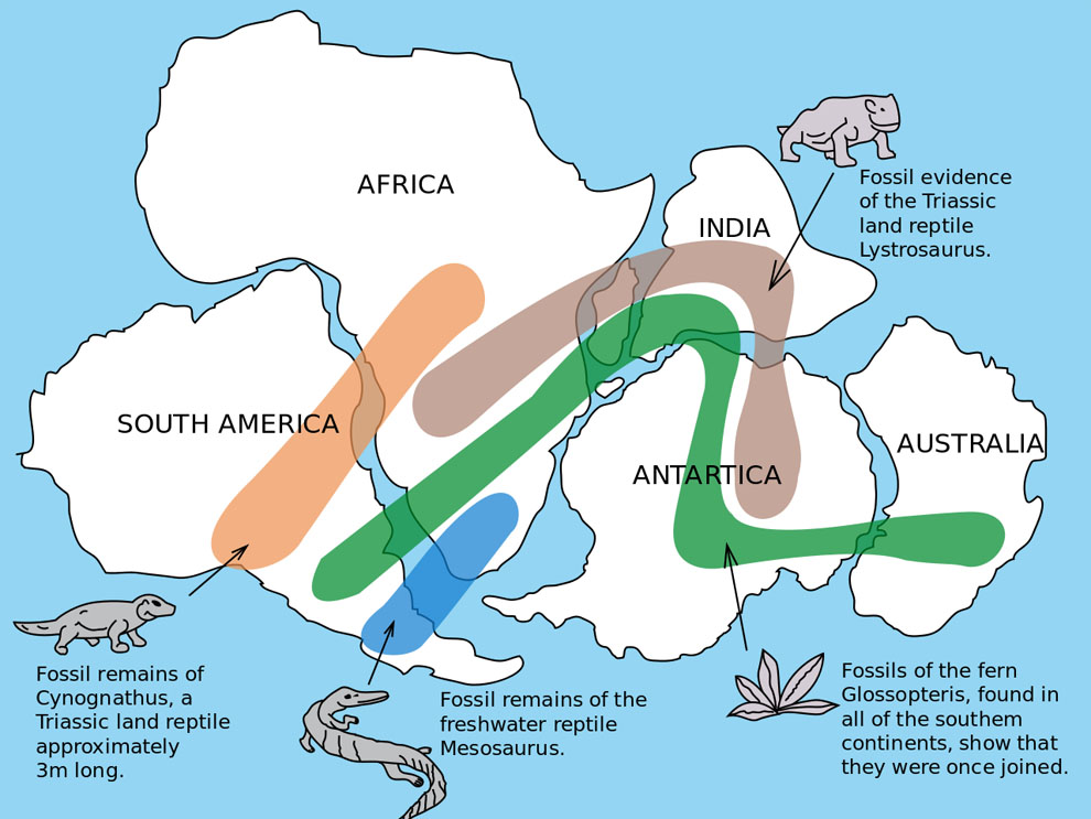
The fact that South America is a mirror image of Africa is presented as a proof of the continental drift theory (see video below for an animation showing the migration of both of these continents).

For hundreds of millions of years, all the land of Earth was joined together in one large mass or super continent. Scientists call it Pangaea (meaning “all lands” in Greek). Then about 200 million years ago the land began to drift apart. It broke into two pieces, and scientists have called the continent in the north Laurasia and the continent in the south Gondwanaland  (named by Eduard Suess, an Austrian geologist).The two large continents continued to break apart into the smaller continents that exist today. Scientists call this movement ‘continental drift’.

Forces responsible for drifting of continents (According to Alfred Wegner)

According to Wegener, the drift was in two directions:

  1. Towards the equatordue to the interaction of forces of gravity, pole-fleeing force (due to centrifugal force caused by earth’s rotation) and buoyancy (ship floats in water due to buoyant force offered by water)
  2. Westwardsdue to tidal currents because of the earth’s motion (earth rotates from west to east, so tidal currents act from east to west, according to Wegener).
  • Wegener suggested that tidal force (gravitational pull of the moon and to a lesser extent, the sun) also played a major role.
  • The polar-fleeing force relates to the rotation of the earth. Earth is not a perfect sphere; it has a bulge at the equator. This bulge is due to the rotation of the earth (greater centrifugal force at the equator).
  • Centrifugal force increases as we move from poles towards the equator. This increase in centrifugal force has led to pole fleeing, according to Wegener.
  • Tidal force is due to the attraction of the moon and the sun that develops tides in oceanic waters (tides explained in detail in oceanography).
  • According to Wegener, these forces would become effective when applied over many million years, and the drift is continuing.

Evidences in support of the continental drift theory

Continental Drift Theory 

Jigsaw Fit - The similarity in outline of the coastlines of eastern South America and West Africa had been noted for some time. The best fit is obtained if the coastlines are matched at a depth of 1,000 meters below current sea level

Geological Fit - When the geology of eastern South America and West Africa was mapped it revealed that ancient rock outcrops (cratons) over 2,000 million years old were continuous from one continent to the other.

Tectonic Fit - Fragments of an old fold mountain belt between 450 and 400 million years ago are found on widely separated continents today.

    • Pieces of the Caledonian fold mountain belt are found in Greenland, Canada, Ireland, England, Scotland and Scandinavia. When these land masses are re-assembled the mountain, belt forms a continuous linear feature.

Glacial Deposits - Today, glacial deposits formed during the Permo-Carboniferous glaciation (about 300 million years ago) are found in Antarctica, Africa, South America, India and Australia.

    • If the continents haven’t moved, then this would suggest an ice sheet extended from the South Pole to the equator at this time – which is unlikely as the UK at this time was also close to the equator and has extensive coal and limestone deposits.
    • If the continents of the southern hemisphere are re-assembled near the South Pole, then the Permo-Carboniferous ice sheet assumes a much more reasonable size

Fossil Evidence - There are many examples of fossils found on separate continents and nowhere else, suggesting the continents were once joined. If Continental Drift had not occurred, the alternative explanations would be:

    • The species evolved independently on separate continents – contradicting Darwin’s theory of evolution.
    • They swam to the other continent/s in breeding pairs to establish a second population. 

Criticisms

  • Wegener failed to explain why the drift began only in Mesozoic era and not before.
  • The theory doesn’t consider oceans.
  • Proofs heavily depend on assumptions that are generalist.
  • Forces like buoyancy, tidal currents and gravity are too weak to be able to move continents.
  • Modern theories (Plate Tectonics) accept the existence of Pangaea and related landmasses but give a very different explanation to the causes of drift.

Airy’s View

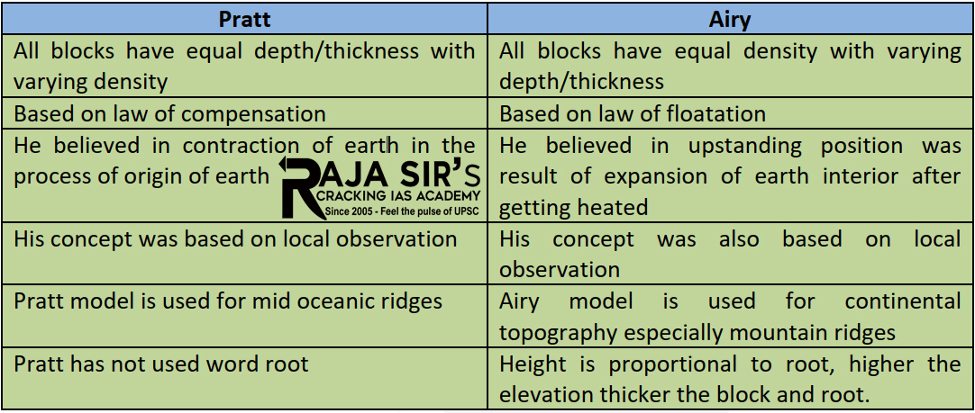
  • The earliest model of isostasy, known as Airy Isostasy, was proposed by George Biddell Airy, a 19th-century British astronomer.
  • The lithosphere, the Earth''s outermost shell, is assumed to be a sequence of blocks of constant density in this model.
  • While the density of these pieces remains constant, their thickness changes.
  • Consider an iceberg drifting in the sea. The "root" of the iceberg lies hidden beneath the water''s surface, while the tip protrudes. The deeper the root spreads beneath the surface, the greater the iceberg''s tip.
  • Similarly, mountainous regions of the Earth have a thicker part of the crust (or a "root") stretching down into the denser mantle in Airy Isostasy.
  • This extra "root" serves to balance out the mountain''s increased mass above the surface.
  • When erosion takes down a mountain''s mass over time, the crust beneath rises in reaction, maintaining isostatic balance.
  • Airy Isostasy, in essence, defines a ''floating'' lithosphere in which the thicker sections extend deeper into the mantle, just like larger icebergs sink deeper into the sea.
  • This model suggests that the Earth''s crust has varying thickness under mountain ranges compared to ocean basins.
  • The thicker portions of the crust (mountains) "float" higher on the asthenosphere, similar to how icebergs with larger submerged parts project more above the water surface.

Pratt’s View

  • With his Pratt Isostasy model, British geologist John Henry Pratt took an alternative method to explain isostatic equilibrium.
  • Pratt''s hypothesis is based on the density of the lithospheric blocks rather than their thickness.
  • Consider a similar-sized wooden block and a sponge floating in a tub of water. Despite being the same size as the wooden block, the sponge will float higher since it is less dense.
  • Similarly, in Pratt Isostasy, less dense portions of the Earth''s crust (such as those made of less dense rock types or those underlain by substantial sedimentary deposits) ''float'' higher on the denser mantle than denser ones.
  • As a result of these density differences within the crust, Pratt''s model implies that the varied elevations we see across the Earth''s surface, from plains to plateaus, are the result of these density variations within the crust itself.
theories of isotasy The concept of isostasy is central to our understanding of various geologic processes and phenomena, including mountain building, sedimentation, erosion, and sea-level changes. It provides insight into the dynamic and responsive nature of the Earth''s crust in relation to the mantle beneath.


POSTED ON 14-10-2024 BY ADMIN
Next previous