- Home
- Prelims
- Mains
- Current Affairs
- Study Materials
- Test Series
July 31, 2024 Current Affairs
Dementia
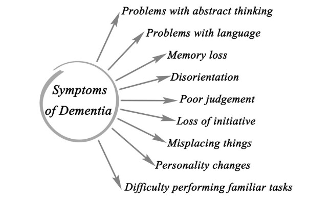
- It is a syndrome – usually of a chronic or progressive nature – that leads to deterioration in cognitive function (i.e. the ability to process thought) beyond what might be expected from the usual consequences of biological ageing.
- It affects memory, thinking, orientation, comprehension, calculation, learning capacity, language, and judgement.
- However, the consciousness is not affected.
- 65% of total deaths due to dementia are women, and disability-adjusted life years (DALYs) due to dementia are roughly 60% higher in women than in men.

Treatment:
- There is currently no treatment available to cure dementia, though numerous new treatments are being investigated in various stages of clinical trials.
Global Scenario:
- Dementia is currently the seventh leading cause of death among all diseases and one of the major causes of disability and dependency among older people worldwide.
- More than 55 million people (8.1% of women and 5.4% of men over 65 years) are living with dementia.
- This number is estimated to rise to 78 million by 2030 and to 139 million by 2050.
- WHO’s Western Pacific Region has the highest number of people with dementia (20.1 million), followed by the European Region (14.1 million).
Landslides flatten Wayanad villages.
What is a Landslide?
- A Landslide is a geological phenomenon involving the downward movement of a mass of rock, soil, and debris on a slope.This movement can vary in scale from small, localized shifts to massive and destructive events.
- Landslides can occur on both natural and man-made slopes, and they are often triggered by a combination of factors such as heavy rainfall, Earthquake,volcanic activity, human activities (such as construction or mining), and changes in groundwater levels.
Types of Landslides
- Falls – They refer to the type of landslide that involves the collapse of material from a cliff or steep slope, which then falls down the slope and collects near the base.
- Topples – Under this type of landslide, the falling mass undergoes forward rotation and movement around an axis or point at or near the base.
- Slides – Under this type of landslide, there is a distinct zone of weakness that separates the moving material from a more stable underlying material.
Landslide Prone Areas in India
ISRO has recently released the Landslide Atlas of India. As per this atlas, some of the prominent statistics regarding landslides in India are as follows:
- India is among the top five landslide-prone countries in the world.
- Excluding snow-covered areas, around 12.6 percent of India’s geographical land area is prone to landslides.
A rough break-up of reported landslides in India is as follows:
- About 66.5 percent from the North-Western Himalayas
- About 18.8 percent from the North-Eastern Himalayas
- About 14.7 percent from the Western Ghats.
As per the Landslide Atlas of India, major landslide prone areas in India are as follows:
- The North-eastern Region(comprises about 50 percent of the total landslide prone areas in India)
- Areas of Uttarakhand, Himachal Pradesh, and Jammu & Kashmirlying along the Himalayas.
- Areas of Maharashtra, Goa, Karnataka, Kerala, and Tamil Nadulying along the Western Ghats.
- The Araku region in Andhra Pradeshalong the Eastern Ghats.
Initiatives taken by the Government to mitigate the risk of landslides
- National landslide risk management strategy: This is a comprehensive document that addresses all the components of landslide disaster risk reduction and management, such as hazard mapping, monitoring, early warning system, awareness programs, capacity building, training, regulations, policies, stabilization and mitigation of landslides, etc
- Landslide Risk Mitigation Scheme (LRMS):This is a scheme under preparation that envisages financial support for site specific landslide mitigation projects recommended by landslide prone states, covering disaster prevention strategy, disaster mitigation and R&D in monitoring of critical landslides, thereby leading to the development of early warning system and capacity building initiatives.
- Flood Risk Mitigation Scheme (FRMS):This is another scheme under preparation that covers activities like pilot projects for development of model multi-purpose flood shelters and development of river basin specific flood early warning system and digital elevation maps for preparation of inundation models for giving early warning to the villagers for evacuation in case of flood.
- National Guidelines on Landslides and Snow Avalanches:These are guidelines prepared by the NDMA to guide the activities envisaged for mitigating the risk emanating from landslides at all levels. The guidelines cover aspects such as hazard assessment, vulnerability analysis, risk management, structural and non-structural measures, institutional mechanisms, financial arrangements, community participation, etc.
- Landslide Atlas of India:The Landslide Atlas of India is a document that provides the details of landslides present in landslide provinces of India, including damage assessment of specific landslide locations. It is prepared by the National Remote Sensing Centre (NRSC), one of the centres of ISRO.
Coastal Zone Management Plans
Coastal Zone Management (CZM) is a process of managing the coast, in all aspects of the including geographical and political boundaries, to achieve sustainability. India has an Exclusive Economic Zone (EEZ) of 2.02 million sq. km and a long coastline of 8,118 km with rich and diverse marine living resources. Coastal zone management is critical for utilising these resources efficiently leading to inclusive growth.
Coastal Zone Management Plan (CZMP)
- Coastal region management plans (CZMP) are designed to promote sustainable development within coastal sector environments.
- Till now the CZMP has been accepted for Odisha, Karnataka and Maharashtra and ICRZP has been authorized for Great Nicobar Island and Little Andaman Island as in line with CRZ Notification, 2019.
Coastal Regulation Zone (CRZ)
- TheMinistry of Environment and Forests (MoEF) under the Environment Protection Act, 1986, issued the Coastal regulation zone notification for regulation of activities in the coastal area.
- Definition:As per the notification, the coastal land up to a distance of 500m from the High Tide Line (HTL) and a stage of 100m along banks of creeks, estuaries, backwaters and rivers subject to tidal fluctuations, is called the Coastal Regulation Zone (CRZ).
CRZ along the country has been placed in four categories, which are as follows:
CRZ I – Ecologically Sensitive Areas.
- Location: They lie between the low and high tide lines.
- In this area, exploration of natural gas and salt extraction are permitted
CRZ II – Shore Line Areas
- Location:The areas that have been developed up to or close to the shoreline.
- Unauthorized structures are not allowed to be constructed in this zone.
CRZ III – Undisturbed Area
- Location: Rural and Urban localities that fall outside I and II.
- Only certain activities related to agriculture even some public facilities are allowed in this zone.
CRZ IV – Territorial Area
- Location:An area covered between the Low Tide Line and 12 Nautical Miles seaward.
- Fishing and allied activities are permitted in this zone.
- No solid waste should be discharged in this zone.
Swaminathan Commission
Swaminathan Commission: An Overview
The Swaminathan Committee refers to the National Commission on Farmers (NCF), which was headed by Professor M.S. Swaminathan, a renowned agricultural scientist.
Formation: The NCF was constituted on November 18, 2004, by the Ministry of Agriculture of the Government of India.
Membership: Alongside Professor M.S. Swaminathan, the committee had two full-time members, four part-time members, and a member secretary.
Objective: The Commission was tasked with creating a sustainable and viable farming system in India by addressing issues such as food and nutrition security and enhancing productivity, profitability, and sustainability.
Reports: The NCF submitted five reports between December 2004 and October 2006.
Recommendations of Swaminathan Commission
- Support for Farm Women:Establishing a National Board for New Deal for Women in Agriculture under the Union Food and Agriculture Minister, with the Union Ministers for Women and Child Development, Rural Development, and Panchayati Raj as co-chairs.
- Farm Schools:Recommending the establishment of Farm Schools to spread innovative farming methods.
- Grain and Fodder Banks:Proposing the establishment of a grain bank and community food and fodder banks.
- Insurance and Soil Testing: Advocating for promoting insurance and setting up a national network of advanced soil testing labs.
- Market Reforms: Suggesting a code of conduct for contract farming, and amendments in the state APMC Acts and the Essential Commodities Act.
- Agricultural Costs and Prices:The Commission made suggestions for the Commission for Agricultural Costs and Prices (CACP), which recommends MSPs, to consider various factors in deciding the level of MSP, including the weighted average cost of production and risk factors.
- Minimum Support Prices (MSP):Recommending timely issuance and better implementation of MSP across regions, but not supporting the specific formula of C2 cost plus 50%.
Way forward
To address the ongoing agricultural crisis, a balanced approach is needed that combines the Swaminathan Commission’s recommendations with the current demands of farmers. This includes legally ensuring MSP, enhancing productivity, and improving market reforms while focusing on sustainability and support for farm women and innovative farming practices.
Pangong Tso lake
- It is one of the most famous lake in Leh Ladakh, derives its name from the Tibetan word, “Pangong Tso”, which means “high grassland lake”.
- It is also known as Pangong Lake which is a long narrow, endorheic (landlocked) lake situated at a height of more than 14,000 ft (4,350 meters) in the Ladakh Himalayas.
- It is the world''s highest saltwater lake.
Who controls Pangong Tso?
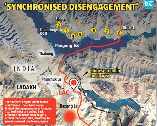
- Nearly two-thirds of the lake is controlled by China, with just about 45 km under Indian control.
- The LAC, running north-south, cuts the western part of the lake, aligned east-west.
- India and China have unsettled borders, and the perception of the LAC differs in multiple sectors, including in Pangong Tso.

The Fingers of Pangong Tso:
- The Pangong Tso is a lake located in eastern Ladakh, and it has a unique shape resembling a boomerang, stretching for about 135 kilometres.
- The lake is characterized by mountain spurs that protrude into the water, known as "fingers".
- The fingers of Pangong Tso are numbered from 1 to 8, with Finger 1 being the closest to the eastern end of the lake and Finger 8 the farthest.
- India and China have differing perceptions of the Line of Actual Control (LAC), which serves as the de facto border between the two countries.
Border Dispute at Pangong Tso:
- India claims control over the lake until Finger 4 but believes its territory extends up to Finger 8.
- The north bank, where the fingers are located, has been the center of clashes and tensions between the two countries.
- Indian troops are stationed near Finger 3, while the Chinese have a base east of Finger 8, claiming territory up to Finger 2.


 Latest News
 General Studies