- Home
- Prelims
- Mains
- Current Affairs
- Study Materials
- Test Series
June 17, 2024 - Current Affairs
ICIMOD, Report 2024 on Hindu-Kush Himalayan
According to the Snow Update Report 2024 from the International Centre for Integrated Mountain Development (ICIMOD), snow persistence in the Hindu Kush Himalaya (HKH) region was notably below normal levels this year.
|
ICIMOD
|
Key Findings of the ICIMOD Report:
- Comparison with Historical Records: The report analysed snow persistence in the Hindu Kush Himalaya (HKH) region from 2003 to 2024 and compared snow persistence in November 2023-April 2024 with historical averages.
- Below-average Snow Cover: The Indus, Ganga, and Brahmaputra river basins experienced reduced snow cover, with decreases of 23%, 17%, and 15% respectively compared to the average from 2003-2023.
- Dramatic Fall in Specific Basins: The Helmand River basin, originating from the HKH region and flowing into Afghanistan and Iran, saw a significant 31.8% decrease in snow persistence. The Amu Darya river basin, one of Central Asia’s longest rivers, experienced its lowest snow persistence with a notable 28.2% decrease below normal levels.
- Consistent Trend: Over the past 22 years, 13 have recorded below-average seasonal snow persistence in the HKH region, indicating a consistent trend of decreasing snow amounts and duration in 2024.
- Regional Trends: There is a gradient of decreasing below-average snow persistence from east to west across the HKH region, with the most pronounced declines observed in the western regions, where snow’s contribution to water supply is significant.
- Implications for Water Security: Below-average snow accumulation poses a substantial risk to early summer water availability this year, affecting water security in the region.
Way forward:
- Proactive Stakeholder Engagement: Stakeholders must take proactive steps to address challenges, mitigate potential water shortages, update plans to manage water stress effectively, and communicate risks to communities.
- Prompt Implementation of Drought Management Strategies: Governments need to swiftly implement drought management strategies to safeguard water resources and support communities during periods of reduced precipitation.
- Enhanced Water Management: Promoting rainwater collection for irrigation and other activities can significantly enhance water management practices, improving resilience to water scarcity.
- Collaborative Water Governance: Countries sharing transboundary rivers should collaborate to revise and strengthen water management laws, ensuring long-term resilience to climate change impacts on water resources.
|
Hindu Kush Himalaya Region |
India refuses to endorse Ukraine meet statement
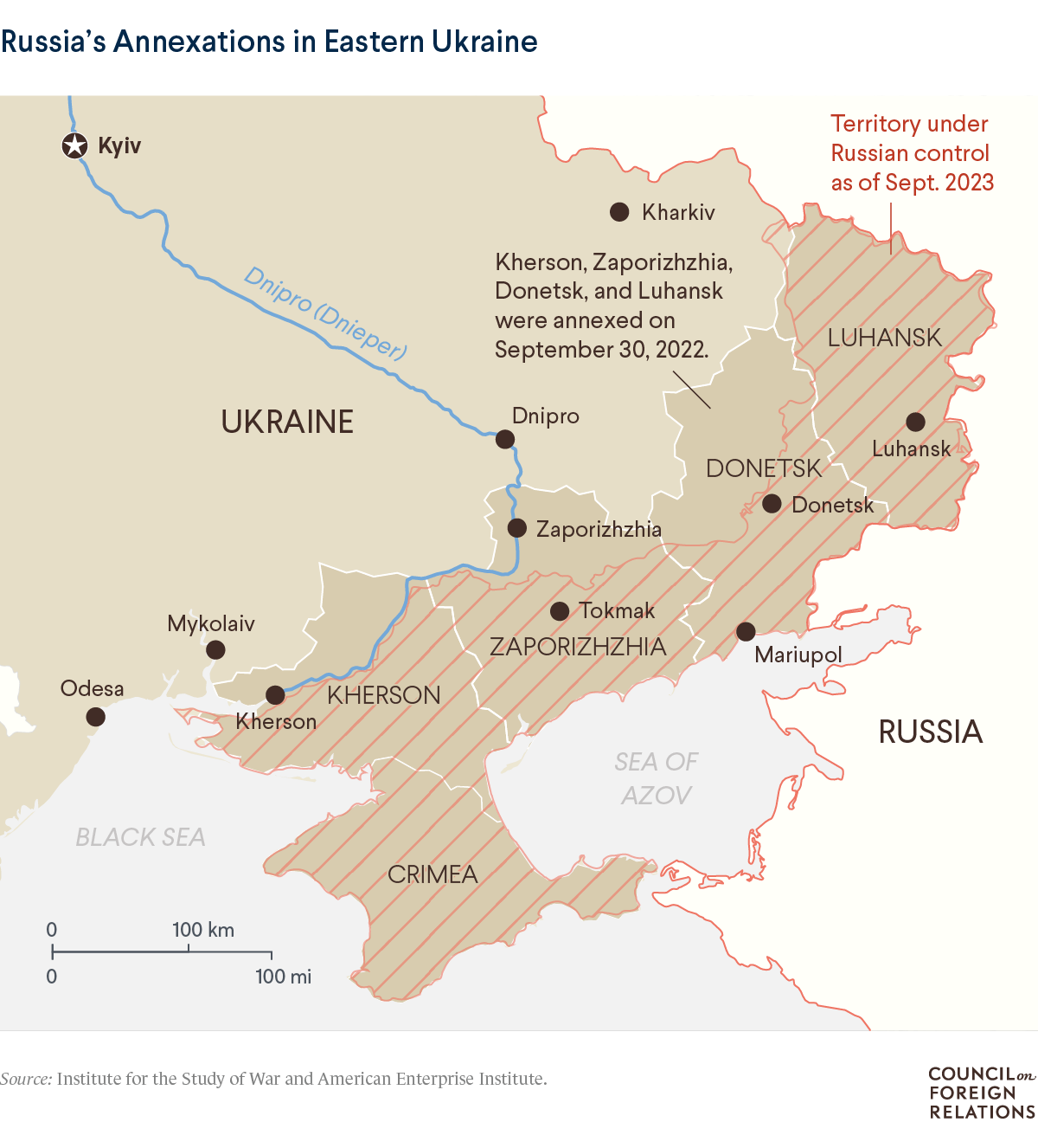
Recently, India underscored that achieving peace requires proposals acceptable to both Russia and Ukraine, and therefore chose to disassociate from the final document issued on June 16 at the conclusion of the Peace Summit in Switzerland.
Ukraine Peace Summit in Switzerland
Key Highlights of the Ukraine Peace Summit in Switzerland:
- Attendance and Endorsement: More than 80 countries participated in the summit and endorsed the “Joint Communique on a Peace Framework.” The communique emphasised the importance of protecting Ukraine’s territorial integrity, based on Ukraine’s peace formula and the principles of the UN Charter.
- Non-Endorsing Countries: India, Saudi Arabia, South Africa, Thailand, Indonesia, Mexico, and the United Arab Emirates did not sign the communique. Brazil attended as an observer, while China declined the invitation to participate.
- India’s Participation and Stance: India attended the summit but chose not to endorse the final document. India’s stance is based on the principle that any peace proposal must be acceptable to both Russia and Ukraine for it to be sustainable. The Ministry of External Affairs (MEA) reiterated India’s commitment to understanding diverse perspectives and pursuing a resolution through dialogue and diplomacy.

Why did India Refuse?
- Neutrality and Balanced Approach: India adheres to a policy of neutrality and balanced diplomacy in international conflicts. By abstaining from taking sides in the Russia-Ukraine conflict, India aims to maintain positive diplomatic relations with both nations.
- Emphasis on Mutually Acceptable Solutions: India believes that sustainable peace can only be achieved through proposals that are mutually acceptable to both Russia and Ukraine. This approach underscores India’s commitment to promoting dialogue and practical engagement between the conflicting parties.
- Strategic and Diplomatic Considerations: By refraining from endorsing the communique, India preserves its potential role as a trusted mediator in international disputes. This stance helps safeguard its strategic partnerships, particularly with Russia, and takes into account broader geopolitical concerns such as food and energy security.
Hence, India’s decision underscores its commitment to neutrality, advocating for peace proposals acceptable to both Russia and Ukraine. It aims to preserve diplomatic relations and safeguard strategic interests amidst evolving global geopolitical dynamics.
DRDO developed Woman-led start-up : Divya Drishti
- Recently, a start-up named Ingenious Research Solutions Pvt Ltd. collaborated with the Centre for Artificial Intelligence & Robotics (CAIR), a DRDO laboratory based in Bangalore, to develop an AI tool called ‘Divya Drishti.’
- ‘Divya Drishti’ integrates facial recognition with immutable physiological parameters such as gait and skeleton, creating a robust biometric authentication system.
- Biometric Authentication: This tool utilises both facial recognition and gait analysis, offering a dual-layered approach that enhances accuracy in identifying individuals and reduces the risks of false positives and identity fraud.
- Applications: ‘Divya Drishti’ has applications across various sectors including Defence, Law Enforcement, Corporate environments, and Public Infrastructure.
- Supported by: The development of this AI tool was supported by the Technology Development Fund (TDF), showcasing DRDO’s commitment to nurturing start-ups in the defence and aerospace sectors as part of the ‘Aatmanirbhar Bharat’ initiative.
|
Defence Research and Development Organization (DRDO) |
Centre for Artificial Intelligence and Robotics (CAIR):
About: CAIR, a prominent DRDO laboratory, specialises in research and development in Artificial Intelligence, Robotics, Command and Control, and Information and Communication Security.
Role: CAIR plays a crucial role in influencing national technology policies, emphasising the importance of national security and fostering self-reliance in advanced technologies.
Olympus Mons
Recently, water frost has been observed on the towering Tharsis volcanoes, including the massive Olympus Mons near Mars’s equator, marking the first detection of such frost in this region.

Olympus Mons
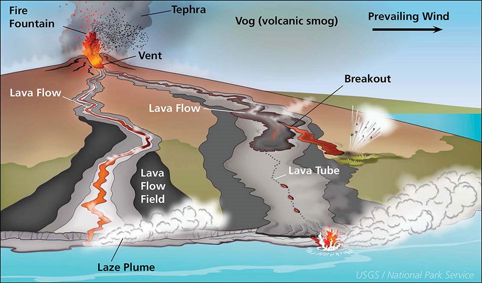
- Olympus Mons is a shield volcano located in Mars’ western hemisphere.
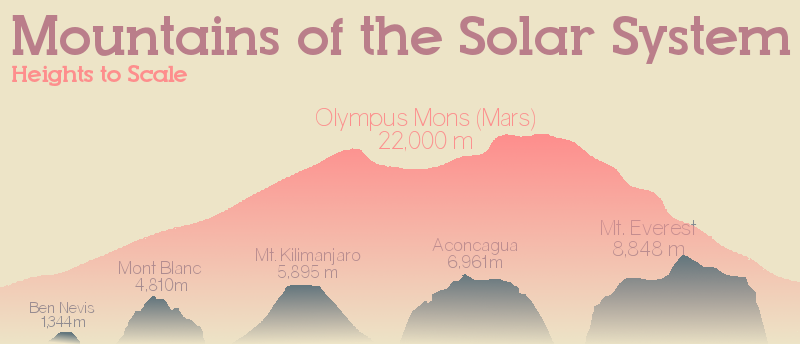
- It stands as the highest point on Mars and holds the title of the largest known volcano in the solar system.
- Rising to a height of 16 miles (24 kilometres), it towers approximately three times higher than Mt. Everest.
- With a diameter of 340 miles (550 kilometres), Olympus Mons covers an area larger than the entire Hawaiian Islands chain.
- By comparison, Earth’s largest volcano, Mauna Loa in Hawaii, spans 120 kilometres across and reaches 9 kilometres in height.
- Olympus Mons is estimated to be around 3.5 billion years old, forming early in Mars’ history.
- The volcano features a very gentle slope, ranging only between 2 to 5 degrees, giving it a remarkably flat appearance.
- At its summit lies a caldera, a large depression resulting from volcanic activity, which spans approximately 50 miles (80 kilometres) wide.
- This caldera is composed of several overlapping pits formed during different eruptive phases.
- In contrast, many Earth-based volcanoes typically exhibit a simpler, single caldera structure.
Why are the mountains so tall?
Limited Plate Movement: Mars experiences minimal tectonic activity, with both the hot spot and crust remaining relatively stationary. This lack of movement allows lava to accumulate in one location, forming large volcanoes like Olympus Mons instead of volcanic island chains typical on Earth.
Extended Lifespan: Martian volcanoes maintain continuous activity over millions of years, resulting in a steady accumulation of magma in specific areas on Mars’ surface.
Shield Volcano Type: Olympus Mons is a shield volcano, characterised by its gentle eruption style where lava flows slowly down its sides rather than erupting violently. This type of volcano contributes to Olympus Mons’ broad, squat appearance with an average slope of only 5 percent.
Structural Features:
Calderas: At the summit of Olympus Mons, six collapsed craters, known as calderas, are stacked on top of each other, creating a depression measuring 53 miles across.
Outer Escarpment: Surrounding the volcano’s perimeter is a cliff or escarpment that rises as high as 6 miles (10 km) above the surrounding terrain. This cliff alone matches the height of Earth’s Mauna Loa volcano.
Base Depression: The base of Olympus Mons is marked by a wide depression formed as the immense weight of the volcano presses into Mars’ crust
Ephemeral Frost Discovered on Mars’ Olympus Mons:
- Ephemeral frost has been discovered on Mars’ Olympus Mons, with approximately 150,000 tonnes of water cycling daily, according to findings from the European Space Agency’s ExoMars Trace Gas Orbiter (TGO) NOMAD instrument.
- The frost was initially detected atop the Olympus Mons volcano by the ExoMars Trace Gas Orbiter’s NOMAD instrument.
- The Mars Express orbiter further confirmed the unexpected presence of frost across multiple volcanoes in the Tharsis region.
- The frost patches are remarkably thin, about the width of a human hair, and cover extensive areas within the summit calderas of these volcanoes.
- This amount of frost translates to 150,000 tonnes of water exchanging between the surface and atmosphere each day during Mars’ cold seasons, equivalent to 60 Olympic-sized swimming pools.
- The frost is transient, present for only a few hours around sunrise before evaporating in the daylight, highlighting unique microclimates within the deep volcanic calderas.
- Understanding the formation of this ephemeral frost provides insights into Mars’ atmospheric dynamics and potential locations of liquid water, crucial for future robotic and human exploration missions.
|
Shield Volcano
|
Nagastra – 1
Indian Army has received the 1st batch of man-portable suicide drones, Nagastra-1.
The high-tech drones are designed and developed indigenously by Economic Explosives Limited (EEL), a subsidiary of Solar Industries, Nagpur.

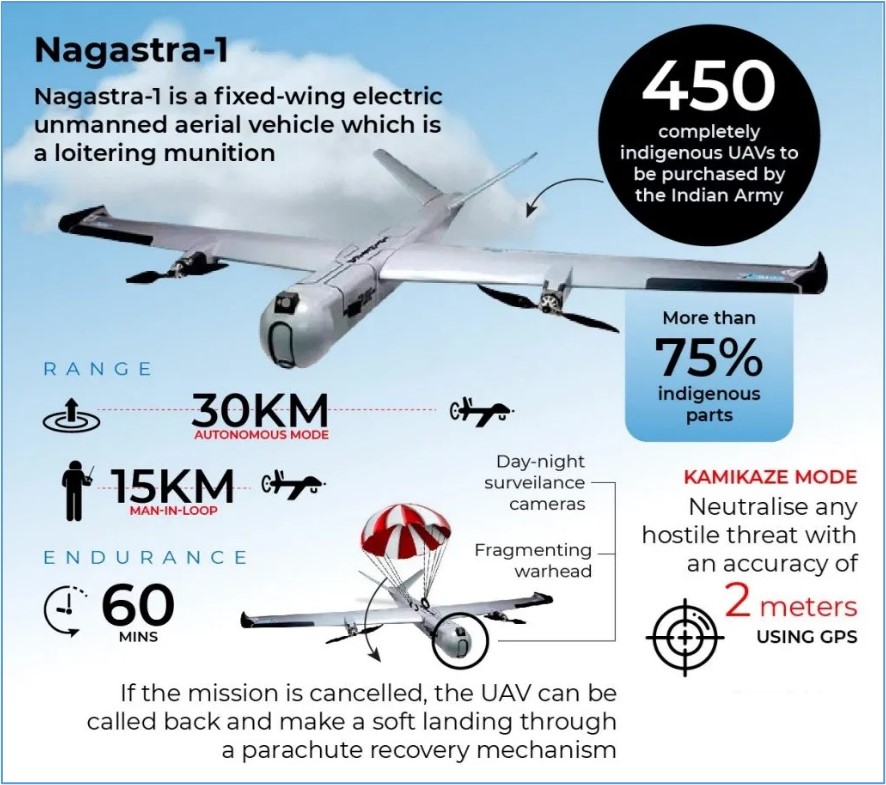
- Nagastra is a fixed-wing electric unmanned aerial vehicle with an endurance of 60 minutes.
- Unlike other weapons, Solar’s Nagastra has the capability to abort an attack if necessary and can be safely retrieved.
- It is named a loitering munition weapon due to its ability to hover over the target.
- It can carry a 1-kilo warhead and carry out a precision strike via GPS with an accuracy of within two metres.
- It offers a 15 km range with man-in-loop control and extends up to 30 km in autonomous mode.
- Due to its electric propulsion system, Nagastra-1 provides a low acoustic signature, making it almost undetectable at altitudes over 200 metres.
- It has a ‘Kamikaze mode’ in which it can search and destroy any target by crashing into it.
- It is equipped with day and night surveillance cameras.
- It has been designed to hit enemy training camps, launch pads, and infiltrators and thus reduce risk to soldiers.


 Latest News

 General Studies