


 Latest News
Mar 05, 2022
WORLD WILDLIFE DAY 2022: KNOW ABOUT THE HISTORY, THEME, AND SIGNIFICANCE
Every year on March 3, World Wildlife Day is observed to raise awareness about the conservation of wildlife.
 World Wildlife Day 2022
 Biju Swasthya Kalyan Yojana.
 Highlights of the Study
 About War Crime
 What is co-location?
 Tapi Riverfront Development Project
 World Glaucoma Week
World Wildlife Day 2022
- This year, it is being celebrated under the theme ‘Recovering key species for ecosystem restoration’.
- Under the theme, WWD seeks to draw attention to the conservation status of some of the most critically endangered species of wild fauna and flora, and to drive discussions towards imagining and implementing solutions to conserve them.
- In 2022, World Wildlife Day will therefore drive the debate towards the imperative need to reverse the fate of the most critically endangered species, to support the restoration of their habitats and ecosystems and to promote their sustainable use by humanity.
- All conversations will be inspired by and seek to inform efforts towards the achievement of UN Sustainable Development Goals 1 (No Poverty), 2 (Zero hunger) 12 (Ensure sustainable consumption and production patterns), 13 (Climate Action) 14 (Life Below Water) and 15 (Life on Land).
- On December 20, 2013 — at its 68th session — the United Nations General Assembly (UNGA) proclaimed March 3 as UN World Wildlife Day to celebrate and raise awareness of the world’s wild animals and plants.
- It is also the day of the signature of the Convention on International Trade in Endangered Species of Wild Fauna and Flora (CITES) in 1973.
- Further, the UNGA resolution designated the CITES Secretariat as the facilitator for the global observance of this special day for wildlife on the UN calendar. Since then, it has become the most important global annual event dedicated to wildlife.
- The day is crucial as climate change and several other factors have posed serious dangers to wildlife, endangering several species.
- According to the International Union for Conservation of Nature (IUCN) Red List of Threatened Species, over 8,400 species of wild fauna and flora are critically endangered. On the other hand, around 30, 000 more are understood to be endangered or vulnerable.
- Thus, it is believed that over a million species are threatened with extinction. As such, this continued loss is not just dangerous to the lives of wildlife but also human beings as we all rely on wildlife and other resources for our needs.
- It is observed to maintain the balance of our ecosystem, it is significant to pay attention to the critical issues affecting the well-being of flora and fauna. We are committed to recovering key species for ecosystem restoration.
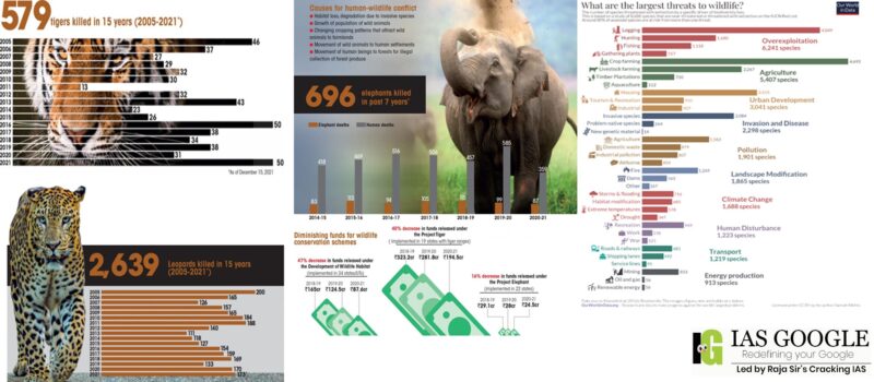
- The headline message is that the largest threat to wildlife is overexploitation – the harvesting of animals for meat, products such as horns and medicines, logging, fishing – and agriculture. These have been the largest threats to biodiversity for millennia, and this still holds true today.
- The expansion of land for agriculture is the leading driver of deforestation and habitat loss. 40% of tropical deforestation is driven by pasture for beef production; 18% for palm oil and soybeans; and another 13% for forest products such as paper and wood.
- Human developments such as housing, industry, recreational development such as golf courses, and roads also threaten thousands of species. One of the biggest impacts of this infrastructure is its impact on habitat fragmentation.
- The fires that swept across the Amazon and Australia rightly drew attention to just how fragile the most important ecosystems are. Half of the world’s original forests are gone, and what remains is being cut down ten times faster than it can be replaced.
- Whether accidentally or intentionally introduced, the non-native species grow and reproduce rapidly, then spread across ecosystems aggressively. They are one of the leading threats to native wildlife, putting 42% of threatened or endangered species at risk.
- There are 500 times more pieces of microplastic in the sea than there are stars in our galaxy. Eight hundred million tonnes of plastic are dumped into the ocean each year, washing up on previously pristine parts of the planet and is a threat to the survival of more than 600 species of marine wildlife.
- From more regular and fiercer storms to more prolonged and more intense droughts, the impact of climate change is rising ocean temperatures and diminishing Arctic Sea ice affecting marine biodiversity, shifting vegetation zones and forcing species to adapt to new conditions.
- Deforestation or removal of a forest for urban use and plantation is the biggest threat to the wildlife of India, India is one of the top 10 countries in the world in the amount of forest loss in 2009, affected the wild animals and birds.
- Poaching is one of the ways of illegal hunting of wild animals for trophies, Ivory, Fur of several animals and claw. Top endangered species of India like elephants, tiger and Rhino are prime target of poaching in India for wildlife trade.
- Hunting or killing of wild animals for food, recreation and bush meat is the illegal killing. Killing and hinting of India’s majestic wild animals is not only an environmental crime but also a threat to the wildlife cycle.
- Over last few decades, Roadkill have become a new enemy of India’s wildlife, as number of wild animals killed by motor vehicles on highways. Lack of prey pushing the Indian wild animals towards the cities along with new highways passing through the jungle.
- Electric fences are used today for agricultural fencing and other security sensitive places to control the movements of wild animals. Death of animals in India increasing due to Electrocution, like reported from Odisha lost 179 elephants, Tiger deaths by electrocution in Maharashtra, Leopards die after being electrocuted in Gujarat and Karnataka.
- Human wildlife conflict in India is the result of habitat loss, degradation of habitat, loss of prey and growing human population. Attacks of leopard in India are still common and there were cases of man eater tigers of Sundarbans, Wild Elephant attacks in Kerala, bear attack in Chhattisgarh and millions of snakebite cases in India.
- Volunteer with organizations in your area to restore native forests, grasslands, and coastal ecosystems by planting native species, manually removing invasive plant species, and taking out old fences.
- Reduce:
- Manufacturing consumer products uses energy and natural resources, and creates waste and pollution.
- When we consume less, we need fewer natural resources and produce less waste.
- Some waste, like plastic bags and bottles, can make its way into wildlands and oceans, with negative consequences for endangered species and other animals.
- Reuse:
- Do not throw it away if it still has a use! If you have unwanted books, toys, clothes or other items in good condition, consider giving them to charity instead of throwing them in the trash.
- Recycle:
- Avoid disposable products and products with excessive packaging or packaging that cannot easily be recycled.
- Dispose of electronics, batteries, and other potentially hazardous materials at municipal collection centers that will handle them properly.
- Save energy. Many power plants rely on coal and other fossil fuels that damage wildlife's habitat when they are extracted, and pollute the environment and contribute to climate change when burned. You can also consider joining a community solar program or adding solar technology to your home or business.
- Conservation of sacred species, groves, forests, and landscapes has been an important aspect of the ethics of Indian culture. The Sacred Groves / Forests are important repositories of floral and faunal diversity that have been conserved by local communities.
- Stringent legislation should be enacted to make it illegal to kill or capture endangered animals or birds. It needs to be made a criminal offence. Such laws should be strictly followed and not only exist on paper.
- Forest authorities should not allow the indiscriminate killing of wild birds and animals, regardless of their abundance.
- More National Parks and Sanctuaries should be built throughout the country to protect the natural environments of wild animals and birds.
- Government should pay attention to conducting proper surveys with existing technologies and innovative techniques such as GIS Mapping, Drones etc.
- In the early 1960s, international discussion began focusing on the rate at which the world’s wild animals and plants were being threatened by unregulated international trade.
- The Convention on International Trade in Endangered Species of Wild Fauna and Flora (CITES) is an international agreement between governments entered into force in 1975, and became the only treaty to ensure that international trade in plants and animals does not threaten their survival in the wild.
- CITES is administered through the United Nations Environment Programme (UNEP). A Secretariat, located in Geneva, Switzerland, oversees the implementation of the treaty and assists with communications between countries.
- Species for which trade is controlled are listed in one of three Appendices to CITES, each conferring a different level of regulation and requiring CITES permits or certificates.
- Includes species threatened with extinction and provides the greatest level of protection, including restrictions on commercial trade. Examples include gorillas, sea turtles, most lady slipper orchids, and giant pandas.
- Includes species that, although currently not threatened with extinction, may become so without trade controls.
- It also includes species that resemble other listed species and need to be regulated in order to effectively control the trade in those other listed species.
- Includes species for which a range of countries have asked other Parties to help in controlling international trade. Examples include map turtles, walruses and Cape stag beetles.
- Until CoP13, these meetings were held every two years; since then, CoPs are held every three years. CoP16 is scheduled to occur from March 3-14, 2013 in Bangkok, Thailand.
- Over the last several decades, CITES has helped ensure global conservation of species.
- The Parties have adopted a 5-year strategic vision to guide CITES through 2013.
- Ensure compliance with and implementation and enforcement of the Convention.
- Secure the necessary financial resources and means for the operation and implementation of the Convention.
- Contribute to significantly reducing the rate of biodiversity loss by ensuring that CITES and other multilateral instruments and processes are coherent and mutually supportive.
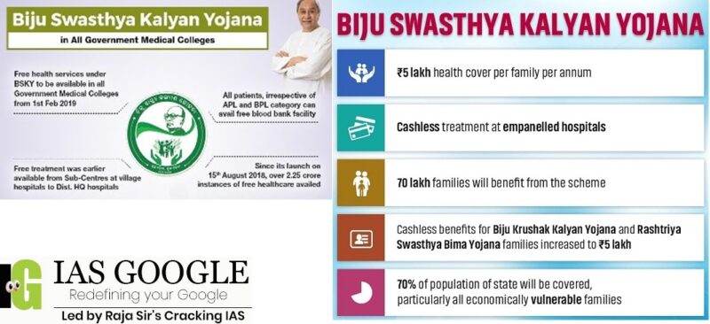
Biju Swasthya Kalyan Yojana.
- The health scheme was launched on August 15, 2018, aimed at providing Universal Health coverage, with special emphasis on the health protection of economically vulnerable families.
- The scheme has two components, one a free health services for all (irrespective of income, status or residence) in all state government healthcare facilities starting from sub center level up to District Head Quarter Hospital level, and two, additional facility of free healthcare beyond District Headquarters hospital level, for over 70 lakh economically vulnerable families in the state.
- Every family enrolled under Biju Swasthya Kalyan Yojana is eligible for Rs 5 lakh from the state government, while women get cover of Rs 10 lakh under this scheme.
- All health services are free of cost, including free drugs, free diagnostics, free dialysis, free cancer chemotherapy, free OT, free ICU, in-patient admission etc., in all government health institutions up to district headquarters hospital level, for all persons.
- The provision of smart health cards for all beneficiaries and expanding the beneficiary base to cover 92.5 lakh families under BSKY. The scheme initially had 71.69 lakh families as beneficiaries.
- Earlier, 69.69 lakh Biju Krushak Kalyan Yojana (BKKY) cardholders and around two lakh BPL, AAY card holders and low-income families were availing the BSKY benefits. Later on, all families covered under the National Food Security Act (NFSA) and SFSA also became eligible for BSKY.
- As many as 183 private hospitals in the state and 17 hospitals outside Odisha were empanelled. All districts in the state were covered by the end of last year.
- As per the existing system, no document is required for cashless healthcare service in government facilities. The beneficiaries will have to produce smart cards or food security cards at the empanelled private hospitals to avail cashless care up to annual financial limit, which will apply for a one-year period. after which it will be auto-renewed.
- Some of the differences involve the package cap, which is Rs 5 lakh a year under Ayushman Bharat but goes up to Rs 10 lakh under BSKY.
- While BSKY covers over 90 lakh families, Ayushman Bharat can cover only 60 lakh families. The central government claims that implementation of the central scheme can help the migrant population of the state access quality healthcare.
- Ayushman Bharat Pradhan Mantri Jan Arogya Yojana is a national public health insurance fund of the Government of India that aims to provide free access to health insurance coverage for low-income earners in the country.
- The programme is part of the Indian government's National Health Policy and is means-tested. It was launched in September 2018 by the Ministry of Health and Family Welfare. That ministry later established the National Health Authority as an organization to administer the program.
- Ayushman Bharat is National Health Protection Scheme, which will cover over 10 crore poor and vulnerable families (approximately 50 crore beneficiaries) providing coverage up to 5 lakh rupees per family per year for secondary and tertiary care hospitalization.
- Ayushman Bharat - National Health Protection Mission will subsume the on-going centrally sponsored schemes - Rashtriya Swasthya Bima Yojana (RSBY) and the Senior Citizen Health Insurance Scheme (SCHIS).
- Benefits of the scheme are portable across the country and a beneficiary covered under the scheme will be allowed to take cashless benefits from any public/private empanelled hospitals across the country. The beneficiaries can avail themselves of benefits in both public and empanelled private facilities.
- One of the core principles of Ayushman Bharat - National Health Protection Mission is to co-operative federalism and flexibility to states.
- For giving policy directions and fostering coordination between Centre and States, it is proposed to set up Ayushman Bharat National Health Protection Mission Council (AB-NHPMC) at apex level Chaired by Union Health and Family Welfare Minister.
- States would need to have a State Health Agency (SHA) to implement the scheme.
- To ensure that the funds reach SHA on time, the transfer of funds from Central Government through Ayushman Bharat - National Health Protection Mission to State Health Agencies may be done through an escrow account directly.
- In partnership with NITI Aayog, a robust, modular, scalable and interoperable IT platform will be made operational which will entail a paperless, cashless transaction.
- It will target about 10.74 crore poor, deprived rural families and identified occupational category of urban workers' families as per the latest Socio-Economic Caste Census (SECC) data covering both rural and urban. The scheme is designed to be dynamic and aspirational and it would take into account any future changes in the exclusion/ inclusion/ deprivation/ occupational criteria in the SECC data.
Highlights of the Study
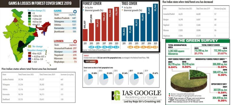
- While the India State of Forest Report (ISFR 2021) says forest cover has increased, a study of the Forest Survey of India maps shows otherwise.
- A recent analysis says the new Forest Survey Report of 2021 records a forest area of 77.53 million hectare (mha) in India, but a forest cover on only 51.66 mha.
- There are states where over 30-50 per cent of the land classified as forests is ‘missing’ from the government’s assessment. Madhya Pradesh, for instance, has ‘lost’ nearly three million ha.
- Tea estates, coconut plantations and housing colonies in cities have been classified as forests — even desert areas have been classified as open forests. There are no technical constraints in classifying forests — we have the technical capacity to differentiate between different kinds of forests and plantations.
- In 2001, efforts were made to ensure accuracy of data, but the opposite happened — due to the definition used, forest cover was shown to rise steeply, while there was no change or negative change in the forest cover on the ground.
- The definition of ‘forest area’ outside recorded forests includes non-forest plantations. As the definition of a forest includes any hectare of land with a tree cover of 10 per cent or more, these areas would include plantations of all kinds, ranging from coconut to even tea.
- In fact, between the assessment 2019 and 2021, India’s forest cover has grown by a mere 0.2 per cent, and most of this ‘growth’ has been in ‘open forests’ (with canopy cover of 10-40 per cent), on lands outside recorded forest areas.
- According to the UN Food and Agriculture Organization (FAO), a forest is defined as land spanning more than 0.5 hectares (1.2 acres) with trees higher than 5 meters (16 ft) and a canopy cover of more than 10%, or trees able to reach these thresholds in situ. It does not include land that is predominantly under agricultural or urban land use.
- Forest cover is one category of terrestrial land cover. It is defined as 25% or greater canopy closure at the Landsat pixel scale (30-m × 30-m spatial resolution) for trees >5 m in height.
- Wood is the major forest producer.
- The timber and sawn up wood (sawdust) obtained from forests are used as basic material for building houses particularly in rural areas.
- Wood, on the other hand, is used as a temporary structural support for the construction of buildings, bridges and furniture.
- It is also a raw material for the manufacture of paper, rayon and film.
- Fuel Wood/Fire Wood:
- In developing countries, the heaviest demand for forests is for fuel wood. More than 1500 million people depend on wood to cook and keep warm.
- Economical uses of forests:
- Forests play a vital role in the life and economy of all the tribes living in their laps.
- They provide food (tubers, roots, leaves and fruits of plants and meat from animals), medicines and other products of commercial use, which form a viable forest-based subsistence pattern.
- Ecological uses of forests:
- Protection of Biodiversity, land &Environment:
- Forests are large biotic communities. They provide shelter and sustenance for a large number of diverse species of plants, animals and micro-organisms. They protect the environment. They prevent erosion of the soil by wind and water. Trees provide shade which prevents the soil from becoming too dry and friable during summer.
- Moderating & Moistening Effects on Climate:
- They also check the velocity of rain drops or wind striking the ground and reduce dislodging of soil particles. The root system of plants firmly binds the soil.
- Retention of Sub-soil Water & Increase in Rainfall Frequency:
- Theyimprove the quality of the soil by increasing its porosity and fertility by contributing humus to it.
- The forest soil absorbs water during rains like a giant sponge and does not allow it to evaporate or run-off quickly. Forests increase atmospheric humidity by drawing sub-soil water and sending it out in the air during transpiration.
- The increased humidity helps plants and animals to survive in a warm season by making it cool and pleasant.
- Pollution Control:
- They play an important role in reducing atmospheric pollution by collecting the suspended particulate matter and by absorbing carbon dioxide etc.
- Forests are the sole providers of natural resources to support indigenous communities. They shield the surrounding areas from extreme weather conditions. They help to reduce Noise Pollution.
- Forest Survey of India (FSI), is a premier national organization under the union Ministry of Environment and Forests, responsible for assessment and monitoring of the forest resources of the country regularly. In addition, it is also engaged in providing the services of training, research and extension.
- Established on June 1,1981, the Forest Survey of India succeeded the "Pre-investment Survey of Forest Resources" (PISFR), a project initiated in 1965 by Government of India with the sponsorship of FAO and UNDP.
- In its report in 1976, the National Commission on Agriculture (NCA) recommended the creation of a National Forest Survey Organization for a regular, periodic and comprehensive forest resources survey of the country leading to creation of FSI.
- After a critical review of activities undertaken by FSI, Government of India redefined the mandate of FSI in 1986 in order to make it more relevant to the rapidly changing needs and aspirations of the country.
- To prepare a State of Forest Report biennially, providing assessment of latest forest cover in the country and monitoring changes in these.
- To conduct inventory in forest and non-forest areas and develop database on forest tree resources.
- To prepare thematic maps on 1:50,000 scale, using aerial photographs.
- To function as a nodal agency for collection, compilation, storage and dissemination of spatial database on forest resources.
- To conduct training of forestry personnel in application of technologies related to resources survey, remote sensing, GIS, etc.
- To strengthen research & development infrastructure in FSI and to conduct research on applied forest survey techniques.
- To support State/UT Forest Departments (SFD) in forest resources survey, mapping and inventory.
- To undertake forestry related special studies/consultancies and custom-made training courses for SFD's and other organizations on a project basis.
- It is an assessment of India’s forest and tree cover, published every two years by the Forest Survey of India.
- The first survey was published in 1987, and ISFR 2021 is the 17th.
- India is one of the few countries in the world that brings out such a survey every two years, and this is widely considered comprehensive and robust.
- The ISFR is used in planning and formulation of policies in forest management as well as forestry and agroforestry sectors.
- Three categories of forests are surveyed – very dense forests (canopy density over 70%), moderately dense forests (40-70%) and open forests (10-40%).
- Scrubs (canopy density less than 10%) are also surveyed but not categorised as forests.
- The total forest and tree cover of the country is 80.9 million hectares which is 24.62 percent of the geographical area of the country. As compared to the assessment of 2019, there is an increase of 2,261 sq km in the total forest and tree cover of the country. Out of this, the increase in forest cover has been observed as 1,540 sq km and that in tree cover is 721 sq km.
- Tree cover has increased: India’s forest cover is now 7, 13,789 square kilometers, 21.71% of the country’s geographical area, an increase from 21.67% in 2019. Tree cover has increased by 721 sq km.
- Increase in forest cover has been observed in open forest followed by very dense forest. Top three states showing an increase in forest cover are Andhra Pradesh (647 sq km) followed by Telangana (632 sq km) and Odisha (537 sq km).
- Area-wise Madhya Pradesh has the largest forest cover in the country followed by Arunachal Pradesh, Chhattisgarh, Odisha and Maharashtra. In terms of forest cover as percentage of total geographical area, the top five States are Mizoram (84.53%), Arunachal Pradesh (79.33%), Meghalaya (76.00%), Manipur (74.34%) and Nagaland (73.90%).
- 17 states/UT’s have above 33 percent of the geographical area under forest cover. Out of these states and UT’s, five states/UTs namely Lakshadweep, Mizoram, Andaman & Nicobar Islands, Arunachal Pradesh and Meghalaya have more than 75 percent forest cover while 12 states/UTs namely Manipur, Nagaland, Tripura, Goa, Kerala, Sikkim, Uttarakhand, Chhattisgarh, Dadra & Nagar Haveli and Daman & Diu, Assam, Odisha, have forest cover between 33 percent to 75 percent.
- Total mangrove cover in the country is 4,992 sq km. An increase of 17 sq Km in mangrove cover has been observed as compared to the previous assessment of 2019. Top three states showing mangrove cover increase are Odisha (8 sq km) followed by Maharashtra (4 sq km) and Karnataka (3 sq km).
- Total carbon stock in country’s forest is estimated to be 7,204 million tonnes and there is an increase of 79.4 million tonnes in the carbon stock of country as compared to the last assessment of 2019. The annual increase in carbon stock is 39.7 million tonnes.
- The survey has found that 35.46 % of the forest cover is prone to forest fires. Out of this, 2.81 % is extremely prone, 7.85% is very highly prone and 11.51 % is highly prone.
- Bamboo forests have grown from 13,882 million culms (stems) in 2019 to 53,336 million culms in 2021.
- The Northeast states account: for 7.98% of total geographical area but 23.75% of total forest cover. The forest cover in the region has shown an overall decline of 1,020 sq km in forest cover.
- Largest forested areas: While states in the Northeast continue to have some of the largest forested areas, such as Mizoram (84.5% of its total geographical area is forests) or Arunachal Pradesh (79.3%), the two states have respectively lost 1.03% and 0.39% of their forest cover, while Manipur has lost 1.48 %, Meghalaya 0.43%, and Nagaland 1.88%.
- Environmental factors: The report has attributed the decline in the North-eastern states to a spate of natural calamities, particularly landslides and heavy rains, in the region as well as to anthropogenic activities such as shifting agriculture, pressure of developmental activities and felling of trees. This loss is of great concern as the North-eastern states are repositories of great biodiversity.
- Increase the impact of landslides: While natural calamities may have led to much of the loss, the declining forests will in turn increase the impact of landslides. It will also impact water catchment in the region: which is already seeing degradation of its water resources.
- Management issues: Unlike other states, where forests are clearly managed by the forest department and state governments, the North-eastern states follow a different ownership pattern community ownership and protected tribal land which makes conservation activities challenging.
- Decline in forest cover in the Northeast: Experts have flagged some of its other aspects as causes for concern, such as a decline in forest cover in the Northeast, and a degradation of natural forests.
- Extreme rainfall may also increase in the states of the North East.
- Not a uniform trend: While ISFR 2021 has shown an increasing trend in forest cover overall, the trend is not uniform across all kinds of forests.
- Climate change: The report estimates that by 2030, 45-64% of forests in India will experience the effects of climate change and rising temperatures, and forests in all states (except Assam, Meghalaya, Tripura and Nagaland) will be highly vulnerable climate hot spots. Ladakh (forest cover 0.1-0.2%) is likely to be the most affected.
- Shifting trends: India’s forests are already showing shifting trends of vegetation types, such as Sikkim which has shown a shift in its vegetation pattern for 124 endemic species.
- Forest fire hotspots: In 2019-20, 1.2 lakh forest fire hotspots were detected which increased to 3.4 lakh in 2020-21. The highest numbers of fires were detected in Odisha, Madhya Pradesh and Chhattisgarh.
- According to the long-term trend analysis performed by the FSI, nearly 10.66 per cent area of forest cover in India is under extremely to very highly fire-prone zones.
- The survey results could be misleading as it includes plantations: such as coffee, coconuts or mangoes and other orchards – under forest cover. These plantations are distinctly different from natural forests where one hectare would be home to hundreds of species of trees, plants and fauna, whereas such plantations house only one species of tree.
- Decline in natural forests: Even though ‘very dense forests’ (with canopy density over 70 per cent) have increased by 501 sq km, ‘moderately dense forests’ or ‘natural forests’ (with 40-70 per cent canopy density) have declined by 1,582 sq km.
- Increase in temperature: It predicted that Himalayan states and UTs like Ladakh, Jammu and Kashmir, Himachal Pradesh and Uttarakhand will record the maximum increase in temperature and also possibly experience a decrease in rainfall.
- It does not meet the objectives: The forest survey is carried out as an assessment of India’s biodiversity, but such an overarching survey does not meet that objective.
- In tune with the Government of India’s vision of digital India and the need for integration of digital data sets, FSI has adopted using the vector boundary layers of various administrative units up to districts level as provided by Survey of India along with digital open series topo sheets, in order to ensure comprehensive compatibility with the geographical areas as reported in Census, 2011.
- The biennial assessment of forest cover of the country using mid-resolution Satellite data is based on interpretation of LISS-III data from Indian Remote Sensing satellite data (Resourcesat-II) with a spatial resolution of 23.5 meters with the scale of interpretation 1:50,000 to monitor forest cover and forest cover changes at District, State and National level.
- This information provides inputs for various global level inventories, reports such as GHG Inventory, Growing Stock, Carbon Stock, Forest Reference Level (FRL) and international reporting to UNFCCC targets under CBD Global Forest Resource Assessment (GFRA) for planning and scientific management of forests.
- Satellite data for the entire country was procured from NRSC for the period October to December 2019. The satellite data interpretation is followed by rigorous ground truthing. Information from other collateral sources is also used to improve the accuracy of the interpreted image.
- The accuracy level achieved in the current assessment is significantly high. The accuracy of forest cover classification has been assessed 92.99%. The accuracy of classification between forest and non-forest classes has been assessed 95.79% against internationally accepted accuracy of classification of more than 85%.
- In the present ISFR 2021, FSI has included a new chapter related to the assessment of forest cover in the Tiger Reserves, Corridors and Lion conservation area of India. In this context, the decadal assessment of change in forest cover within Tiger Reserves, Corridors and Lion conservation area helps in assessing the impact of conservation measures and management interventions that have been implemented over the years.
- For decadal assessment, change in forest cover, during the period between ISFR 2011 (data period 2008 to 2009) and the current cycle (ISFR 2021, data period 2019-2020) within each Tiger Reserves has been analysed.
- A new initiative of FSI has also been documented in the form of a chapter, where the ‘Above Ground Biomass’ has been estimated. FSI, in collaboration with Space Application Centre (SAC), ISRO, Ahmedabad, initiated a special study for estimation of Above Ground Biomass (AGB) at pan-India level, using L- band of Synthetic Aperture Radar (SAR) data. The results for the States of Assam and Odisha (as well as AGB maps), were presented earlier in ISFR 2019. The interim results for AGB estimates (and AGB maps) for the entire country are being presented as a new chapter in ISFR 2021. The detailed report will be published after completion of the study.
- FSI in collaboration of with Birla Institute of Technology & Science (BITS) Pilani, Goa Campus has performed a study based on ‘Mapping of Climate Change Hotspots in Indian Forests’. The collaborative study was carried out with the objective to map the climatic hotspots over the forest cover in India, using computer model-based projection of temperature and rainfall data, for the three future time periods i.e., year 2030, 2050 and 2085.
- The report also contains information on various parameters State/UT wise. Special thematic information on forest cover such as hill, tribal districts, and north eastern regions has also been given separately in the report.
- It is expected that the information given in the report would provide valuable information for policy, planning and sustainable management of forest and tree resources in the country.
- National Mission for a Green India: It is one of the eight Missions under the National Action Plan on Climate Change (NAPCC) with the objective to safeguard the biological resources of our nation and associated livelihoods against the peril of adverse climate change and to recognise the vital impact of forestry on ecological sustainability, biodiversity conservation and food-, water- and livelihood security.
- National Afforestation Programme (NAP): It has been implemented since 2000 for the afforestation of degraded forest lands.
- Compensatory Afforestation Fund Management and Planning Authority, (CAMPA Funds):90% of the fund is to be given to the states while 10% is to be retained by the Centre.
- The funds can be used for treatment of catchment areas, assisted natural generation, forest management, wildlife protection and management, relocation of villages from protected areas, managing human-wildlife conflicts etc.
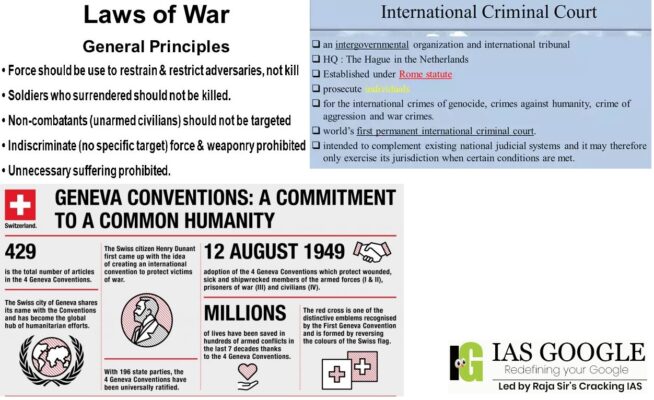
About War Crime
- War crimes are defined as serious violations of humanitarian laws during a conflict. The definition, established by the Rome Statute of the International Criminal Court (ICC) is derived from the 1949 Geneva Conventions and is based on the idea that individuals can be held liable for the actions of a state or its military.
- The UN Office on Genocide Prevention and the Responsibility to Protect separates war crimes from genocide and crimes against humanity. War crimes are defined as occurring in a domestic conflict or a war between two states, while genocide and crimes against humanity can happen in peacetime or during the unilateral aggression of a military towards a group of unarmed people.
- There are specific international standards for war crimes, which are not to be confused with crimes against humanity.
- There is a long list of acts that can be considered war crimes. The taking of hostages, willful killings, torture or inhuman treatment of prisoners of war, and forcing children to fight are some of the more obvious examples.
- Raids on a cities or villages, bombing residential buildings or schools, and even the killing of groups of civilians do not necessarily amount to war crimes — not if their military necessity is justified. The same act can become a war crime if it results in unnecessary destruction, suffering and casualties that exceed the military gain from the attack.
- To decide whether an individual or a military has committed a war crime, international humanitarian law lays down three principles: distinction, proportionality and precaution.
- Proportionality prohibits armies from responding to an attack with excessive violence. If a soldier is killed, for example, you cannot bomb an entire city in retaliation.
- It is also illegal to target objectives that are “expected to cause incidental loss of civilian life, injury to civilians, damage to civilian objectives, which would be excessive in relation to the concrete and direct military advantage anticipated,” according to the International Committee of the Red Cross.
- Precaution requires parties to a conflict to avoid or minimize the harm done to the civilian population.
- Finally, the principle of distinction says that you have to be constantly trying to distinguish between civilian and belligerent populations and objects.
- For example, attacking a barrack where there are people who have said they no longer participate in the conflict can be a war crime. “The same goes for bombing a military base where there are generators that supply hospitals with electricity.”
- Civilian and military populations have become increasingly hard to distinguish.
- When ICC prosecutors have reason to believe that a war crime has been committed, they start an investigation to find evidence that could point to specific individuals responsible for those crimes.
- Time is crucial though as evidence can degenerate or disappear. It is very difficult for prosecutors to successfully investigate suspected war crimes after the fact that one party to a conflict may have tampered with evidence or witnesses are no longer around.
- The International Criminal Court is an intergovernmental organization and international tribunal that sits in The Hague, Netherlands.
- The ICC is the first and only permanent international court with jurisdiction to prosecute individuals for the international crimes of genocide, crimes against humanity, war crimes and the crime of aggression.
- It is intended to complement existing national judicial systems, and it may, therefore, exercise its jurisdiction only when national courts are unwilling or unable to prosecute criminals.
- The ICC lacks universal territorial jurisdiction and may only investigate and prosecute crimes committed within member states, crimes committed by nationals of member states, or crimes in situations referred to the Court by the United Nations Security Council.
- The ICC began operations on 1 July 2002, upon the entry into force of the Rome Statute, a multilateral treaty that serves as the court's foundational and governing document.
- States which become party to the Rome Statute become members of the ICC, serving on the Assembly of States Parties, which administers the court.
- As of December 2020, there are 123 ICC member states; 42 states have neither signed nor become parties to the Rome Statute.
- The International Criminal Court (ICC)investigates and, where warranted, tries individuals charged with the gravest crimes of concern to the international community: genocide, war crimes, crimes against humanity and the crime of aggression.
- The Court is participating in a global fight to end impunity, and through international criminal justice, the Court aims to hold those responsible accountable for their crimes and to help prevent these crimes from happening again.
- The ICC has four principal organs:
- The Presidency, the Judicial Divisions, the Office of the Prosecutor and the Registry.
- The President is the most senior judge chosen by his or her peers in the Judicial Division, which hears cases before the Court.
- The Office of the Prosecutor is headed by the Prosecutor who investigates crimes and initiates criminal proceedings before the Judicial Division.
- The Registry is headed by the Registrar and is charged with managing all the administrative functions of the ICC, including the headquarters, detention unit, and public defense office.
- In 1949, an international conference of diplomats built on the earlier treaties for the protection of war victims, revising and updating them into four new conventions comprising 429 articles of law—known as the Geneva Conventions of August 12, 1949. The Additional Protocols of 1977 and 2005 supplement the Geneva Conventions.
- The Geneva Conventions apply in all cases of declared war, or in any other armed conflict between nations.
- They also apply in cases where a nation is partially or totally occupied by soldiers of another nation, even when there is no armed resistance to that occupation.
- Nations that ratify the Geneva Conventions must abide by certain humanitarian principles and impose legal sanctions against those who violate them.
- Ratifying nations must “enact any legislation necessary to provide effective penal sanctions for persons committing or ordering to be committed any of the grave breaches (violations)” of the Conventions.
- The Geneva Convention for the Amelioration of the Condition of the Wounded and Sick in Armed Forces in the Field of August 12, 1949.
- The First Geneva Convention protects soldiers who are hors de combat (out of the battle).
- The 10 articles of the original 1864 version of the Convention have been expanded in the First Geneva Convention of 1949 to 64 articles that protect the following:
- Wounded and sick soldiers
- Medical personnel, facilities and equipment
- Wounded and sick civilian support personnel accompanying the armed forces
- Military chaplains
- Civilians who spontaneously take up arms to repel an invasion
- The Geneva Convention for the Amelioration of the Condition of Wounded, Sick and Shipwrecked Members of Armed Forces at Sea of August 12, 1949
- The Second Geneva Convention adapts the protections of the First Geneva Convention to reflect conditions at sea.
- It protects wounded and sick combatants while on board a ship or at sea. Its 63 articles apply to the following:
- Armed forces members who are wounded, sick or shipwrecked
- Hospital ships and medical personnel
- Civilians who accompany the armed forces
- The Geneva Convention Relative to the Treatment of Prisoners of War of August 12, 1949
- The Third Geneva Convention sets out specific rules for the treatment of prisoners of war (POWs).
- The Convention’s 143 articles require that POWs be treated humanely, adequately housed and receive sufficient food, clothing and medical care.
- Its provisions also establish guidelines on labor, discipline, recreation and criminal trial. Note that prisoners of war may include the following:
- Members of the armed forces
- Volunteer militia, including resistance movements
- Civilians accompanying the armed forces
- The Geneva Convention Relative to the Protection of Civilian Persons in Time of War of August 12, 1949Civilians in areas of armed conflict and occupied territories are protected by the 159 articles of the Fourth Geneva Convention.
- Article 3, common to the four Geneva Conventions, covers situations of non-international armed conflicts. They include traditional civil wars, internal armed conflicts that spill over into other States or internal conflicts in which a third State or a multinational force intervenes alongside the government.
- Two Protocols of 1977: Additional to the four 1949 Geneva Conventions were adopted in 1977. They strengthen the protection of victims of international (Protocol I) and non-international (Protocol II) armed conflicts and place limits on the way wars are fought.
- In 2005, a third Additional Protocol was adopted creating an additional emblem, the Red Crystal, which has the same international status as the Red Cross and Red Crescent emblems.
What is co-location?
- Co-location is typically associated with a facility where a third party can lease a rack/server space along with other computer hardware.
- Co-location facilities provide infrastructure such as power supply, bandwidth, and cooling for setting up servers and storage of data.
- There are allegations that some brokers who had leased space at the NSE co-location facility were able to log on to the NSE’s systems faster with better hardware specifications while engaged in algorithmic trading, which allowed them unfair access and advantage during the period from 2012 to 2014.
- Even a split-second faster access is believed to result in huge gains for a trader. At that time NSE used to disseminate information through unicast, which is a single, direct request sent from one host to another, with only those hosts interacting over the route.
- The Securities and Exchange Board of India (Sebi) found that preferential access was given to stock brokers at NSE’s co-location faculty.
- It found that a single stock broker could log on to multiple dissemination servers through multiple IPs assigned to him.
- It also found that brokers could have multiple logins to a single dissemination server through multiple IPs assigned to it. This gave at least 15 broker's preferential access.
- Following its investigation into the issue, Sebi in 2019 directed NSE to disgorge Rs 624.89 crore, and barred the exchange from accessing the market for funds for six months.
- Sebi also asked the former NSE CEOs, Ramakrishna and Narain, to disgorge 25 per cent of their respective salaries drawn during a certain period.
- They were also prohibited from associating with a listed company or a market infrastructure institution or any other market intermediary for a period of five years.
- The Securities and Exchange Board of India was constituted as a non-statutory body on April 12, 1988 through a resolution of the Government of India.
- The Securities and Exchange Board of India was established as a statutory body in the year 1992 and the provisions of the Securities and Exchange Board of India Act, 1992 (15 of 1992) came into force on January 30, 1992.
- The Securities and Exchange Board of India (SEBI) is the regulatory body for securities and commodity market in India under the ownership of Ministry of Finance, Government of India.
- The Preamble of the Securities and Exchange Board of India describes the basic functions of the Securities and Exchange Board of India as "to protect the interests of investors in securities and to promote the development of, and to regulate the securities market and for matters connected there with or incidental there to".
- SEBI has to be responsive to the needs of three groups, which constitute the market:
- issues of securities
- investors
- market intermediaries
- SEBI has three powers rolled into one body: quasi-legislative, quasi-judicial and quasi-executive. It drafts regulations in its legislative capacity, it conducts investigation and enforcement action in its executive function and it passes rulings and orders in its judicial capacity.
- Though this makes it very powerful, there is an appeal process to create accountability.
- There is a Securities Appellate Tribunal which is a three-member tribunal and is currently headed by Justice Tarun Agarwala, former Chief Justice of the Meghalaya High Court.
- A second appeal lies directly to the Supreme Court. SEBI has taken a very proactive role in streamlining disclosure requirements to international standards.
- to approve by−laws of Securities exchanges.
- to require the Securities exchange to amend their by−laws.
- inspect the books of accounts and call for periodical returns from recognised Securities exchanges.
- inspect the books of accounts of financial intermediaries.
- compel certain companies to list their shares in one or more Securities exchanges.
- registration of Brokers and sub-brokers
Tapi Riverfront Development Project
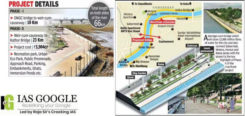
- The Tapi Riverfront Development and Rejuvenation Project is an initiative taken up by the Surat Municipal Corporation to develop the Tapi River (for approx. length of 33km from Kathore Bridge to ONGC Bridge) in a holistic and comprehensive manner and increase its asset value for Surat city.
- This project carefully examines all the issues pertaining to the river and suggests an all-inclusive, immediate and long-term solution.
- Tapi river front development and rejuvenation project incorporates a comprehensive proposal which is unique and context specific, providing a continuous public realm to the city of Surat.
- It considers the existing situation of rivers in context of floods and already constructed flood embankment schemes and proposes a holistic and resilient river edge.
- Riverfront Project can directly impact some of the key pillars of "The Surat Resilience Strategy" for example, Water availability & quality, Dominant sectors of employment & economic development, Ecosystem & environmental regulation, social cohesion, Up-scaling of health, Affordable housing, Connectivity & mobility services with regulation.
- The Tapti River is a river in central India located to the south of the Narmada River which flows westwards before draining into the Arabian Sea.
- The river has a length of around 724kms and flows through the states of Maharashtra, Gujarat and Madhya Pradesh.
- It flows through Surat, and is crossed by the Magdalla, ONGC Bridge.
- Tapi is a perennial river which crosses over Surat city and serves a population of approx. 6.5 million in city. It is a life line of the city.
- It becomes very dynamic in nature at the end of its course when it meets with the Arabian Sea.
- It thus brings the saline tidal back flows in city during high/ low tides all the way up to the Singanpore weir.
- It faces serious challenges of floods for which SMC has planned various flood embankment schemes along the river to accommodate rising levels of floods since 1976.
- More than one lakh trees will also be planted to increase the green cover in the city.
- Heavy plantation drive will be carried out on the riverbank at six places and eight vermicompost plants will also be set up.
- Urban rivers provide a lot of services, but the urban areas are inviting major trouble by destroying them through dumping of solid and liquid waste, encroachments, river front developments, unsustainable mining among others.
- The urban areas also operate in almost total policy vacuum and none of the cities under smart city programs are dealing with Urban rivers with any smartness.
- It helps in the control of floods to the place where they are established. This is achieved through the construction of dams that reserve water and control flooding.
- River basin development encourages the conservation of the environment like control of soil erosion through tree planting.
- River basin development projects are used as research centers for studying ecosystems and their importance to human beings.
- River basin development projects are centered on hydroelectric power generation. electricity generated from hydroelectric power plants is used in manufacturing industries and is also domestically.
- River basin development projects provide water for domestic use and industrial purposes. Water taped at a dam is used for irrigation purposes, in manufacturing industries, and for domestic purposes.
- They lead to improvement of navigation in respective areas, especially when dams are constructed.
- River basin development projects provide water for irrigation schemes hence leading to expansion of farms and increased agricultural production.
- River basin development projects can lead to the development of the fishing industry, especially after the construction of dams.
- It can lead to loss of biodiversity, especially around areas occupied by dams. The dams constructed in river basin development areas cover large areas thus it leads to loss of biodiversity and destruction of the ecosystem
- It can lead to outbreaks of diseases like malaria and bilharzia. Waterborne diseases can become prevalent due to stagnant water in dams which is a suitable environment for breeding mosquitoes and snails which are responsible for the transmission of malaria and bilharzia
- People can be displaced to enable the development of the river basins. Construction and development of river basin project takes large area hence people can be displaced and lose their land and heritage during the process.
- Soil in irrigated areas can be exhausted due to intensive farming.
World Glaucoma Week
- Every 8th individual or nearly 40 million has either glaucoma or is at the risk of developing the disease and 11.2 million Indians suffer from the disease with 1.1 million blinds, including children.
- Screening family members of patients with glaucoma is mandatory, as this disease can affect siblings and children of patients with glaucoma in up to 10-15 per cent of cases.
- The main aim is to bring public focus on glaucoma, which affects people from all walks of life and is the leading cause of irreversible blindness in India.
- Glaucoma is a group of eye conditions that damage the optic nerve, the health of which is vital for good vision. This damage is often caused by an abnormally high pressure in your eye.
- Glaucoma is one of the leading causes of blindness for people over the age of 60. It can occur at any age but is more common in older adults.
- Glaucoma is associated with many risk factors of which the modifiable factor is an increase in eye pressure, and is characterised by damage to the optic nerve leading to irreversible blindness.
- Most often glaucoma causes silent vision loss as the patient will not be symptomatic till a moderate to an advanced stage.
- Early recognition and treatment are important to prevent the disease and it more commonly affects people beyond the age of 40 years. High myopes, diabetics, and those with a family history have a higher risk of developing glaucoma.
- Because vision loss due to glaucoma can't be recovered, it's important to have regular eye exams that include measurements of your eye pressure so a diagnosis can be made in its early stages and treated appropriately. If glaucoma is recognized early, vision loss can be slowed or prevented. If you have the condition, you'll generally need treatment for the rest of your life.
- Your eye constantly makes aqueous humor. As new aqueous flows into your eye, the same amount should drain out. The fluid drains out through an area called the drainage angle. This process keeps pressure in the eye (called intraocular pressure or IOP) stable. But if the drainage angle is not working properly, fluid builds up. Pressure inside the eye rises, damaging the optic nerve.
- The optic nerve is made of more than a million tiny nerve fibers. It is like an electric cable made up of many small wires. As these nerve fibers die, you will develop blind spots in your vision. You may not notice these blind spots until most of your optic nerve fibers have died. If all of the fibers die, you will become blind.
- Elevated eye pressure is due to a build-up of a fluid (aqueous humor) that flows throughout the inside of your eye. This internal fluid normally drains out through a tissue called the trabecular meshwork at the angle where the iris and cornea meet.
- When fluid is overproduced or the drainage system doesn't work properly, the fluid can't flow out at its normal rate and eye pressure increases.
- Glaucoma tends to run in families. In some people, scientists have identified genes related to high eye pressure and optic nerve damage.
- Open-angle glaucoma is the most common form of the disease. The drainage angle formed by the cornea and iris remains open, but the trabecular meshwork is partially blocked. This causes pressure in the eye to gradually increase. This pressure damages the optic nerve. It happens so slowly that you may lose vision before you're even aware of a problem.
- Angle-closure glaucoma, also called closed-angle glaucoma, occurs when the iris bulges forward to narrow or block the drainage angle formed by the cornea and iris. As a result, fluid can't circulate through the eye and pressure increases. Some people have narrow drainage angles, putting them at increased risk of angle-closure glaucoma.
- Angle-closure glaucoma may occur suddenly (acute angle-closure glaucoma) or gradually (chronic angle-closure glaucoma). Acute angle-closure glaucoma is a medical emergency.
- In normal-tension glaucoma, your optic nerve becomes damaged even though your eye pressure is within the normal range. No one knows the exact reason for this. You may have a sensitive optic nerve, or you may have less blood being supplied to your optic nerve. This limited blood flow could be caused by atherosclerosis — the buildup of fatty deposits (plaque) in the arteries — or other conditions that impair circulation.
- It's possible for infants and children to have glaucoma. It may be present from birth or develop in the first few years of life. Optic nerve damage may be caused by drainage blockages or an underlying medical condition.
- In pigmentary glaucoma, pigment granules from your iris build up in the drainage channels, slowing or blocking fluid exiting your eye. Activities such as jogging sometimes stir up the pigment granules, depositing them on the trabecular meshwork and causing intermittent pressure elevations.
- Patchy blind spots in your side (peripheral) or central vision, frequently in both eyes
- Tunnel vision in the advanced stages
- Severe headache
- Eye pain
- Nausea and vomiting
- Blurred vision
- Halos around lights
- Eye redness
- If left untreated, glaucoma will eventually cause blindness. Even with treatment, about 15 percent of people with glaucoma become blind in at least one eye within 20 years.
- Get regular dilated eye examinations. Regular comprehensive eye exams can help detect glaucoma in its early stages, before significant damage occurs.
- Know your family's eye health history. Glaucoma tends to run in families. If you're at increased risk, you may need more frequent screening.
- Exercise safely. Regular, moderate exercise may help prevent glaucoma by reducing eye pressure. Talk with your doctor about an appropriate exercise program.
- Take prescribed eyedrops regularly. Glaucoma eyedrops can significantly reduce the risk that high eye pressure will progress to glaucoma. To be effective, eyedrops prescribed by your doctor need to be used regularly even if you have no symptoms.
- Wear eye protection. Serious eye injuries can lead to glaucoma. Wear eye protection when using power tools or playing high-speed racket sports in enclosed courts.
- There are two main types of laser surgery to treat glaucoma. They help aqueous drain from the eye. These procedures are usually done in the ophthalmologist’s office or an outpatient surgery center.
-
- This surgery is for people who have open-angle glaucoma and can be used instead of or in addition to medications.
- The eye surgeon uses a laser to make the drainage angle work better. That way fluid flows out properly and eye pressure is reduced.
-
- This is for people who have angle-closure glaucoma. The ophthalmologist uses a laser to create a tiny hole in the iris. This hole helps fluid flow to the drainage angle.
- Some glaucoma surgery is done in an operating room. It creates a new drainage channel for the aqueous humor to leave the eye.
-
- This is where your eye surgeon creates a tiny flap in the sclera. He or she will also create a bubble (like a pocket) in the conjunctiva called a filtration bleb.
- It is usually hidden under the upper eyelid and cannot be seen. Aqueous humor will be able to drain out of the eye through the flap and into the bleb.
- In the bleb, the fluid is absorbed by tissue around your eye, lowering eye pressure.
- Glaucoma drainage devices.
- Your ophthalmologist may implant a tiny drainage tube in your eye. The glaucoma drainage implant sends the fluid to a collection area (called a reservoir).
- Your eye surgeon creates this reservoir beneath the conjunctiva. The fluid is then absorbed into nearby blood vessels.
- Cataract surgery.
- For some people with narrow angles, removing the eye's natural lens can lower eye pressure.
- With narrow angles, the iris and the cornea are too close together. This can cover (block) the eye’s drainage channel.
- Removing the eye's lens with cataract surgery creates more space for fluid to leave the eye. This can lower eye pressure.
-
-
POSTED ON 05-03-2022 BY ADMIN
Next previous  General Studies
Political Science and International Relations
Some Reference Essays
List of previous year essay topics (1997-2019)
IAS GOOGLE is googled by the team of Raja Sir’s Cracking IAS Academy. Sources include The Hindu, Indian Express, pib.nic.in, Down To Earth, Economic Times, Vigyan Prasar, AIR and the like. IAS GOOGLE has been prepared in pace with emerging UPSC Trends.