


 Latest News
Mar 27, 2022
WEALTHIEST OIL PRODUCING COUNTRIES MUST PHASE OUT OIL AND GAS BY 2034, POOREST BY 2050
Wealthiest oil producing countries must phase out oil and gas by 2034, poorest by 2050.
 Key Findings
 Key Findings
 Genesis
 Thol Lake
 About Jaisalmer’s Desert Foxes
 What are the GSAT 7 series satellites?
 Key Findings
Key Findings
- The scientific community civil society groups have warned that rapid cuts to greenhouse gas (GHG) emissions are required on an urgent schedule to rein in global warming. And the main culprits – fossil fuels – must be scaled down, both in terms of production and use, complemented with demand-side interventions like reducing energy demand and improving energy efficiency.
- But these changes must be calibrated by wealth and in accordance with the “common but differentiated responsibility” (CBDR) principle of the United Nations Framework Convention on Climate Change”.
- To achieve this, the world could emit only 500 billion tonnes of carbon dioxide (CO2) starting January 2020, the first instalment of the IPCC’s Sixth Assessment report (AR6) said in 2021. At the current rate of emissions, that gives us about a decade to exhaust the 1.5°C budget.
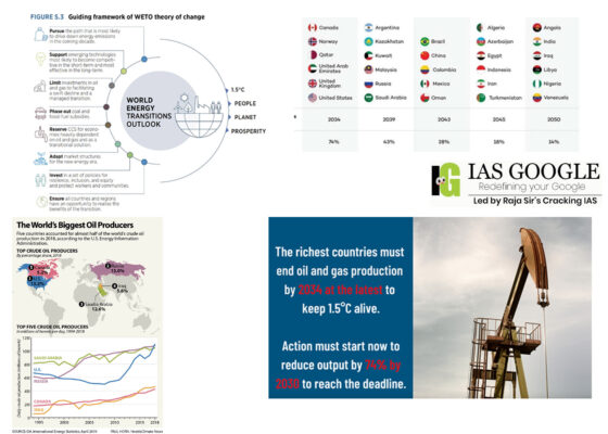
- As many as 19 countries such as Ireland, the United States, Denmark, Netherlands, Austria, Qatar, Norway and Germany fall in the ‘highest capacity’ category and must phase out oil and gas by 2034 to adhere to a 50 per cent chance of limiting warming to 1.5°C, the report said. As many as 25 countries in the ‘lowest capacity’ category including India, Uzbekistan, Libya, Venezuela, Ghana and Bangladesh must do so by 2050, it added.
- Most of the millions of premature deaths from air pollution are due to fossil fuels. Pollution may be indoors e.g., from heating and cooking, or outdoors from vehicle exhaust.
- Fossil-fuel phase-out is the largest part of limiting global warming as they account for over 70% of greenhouse gas emissions, but as of 2020 needs to move 4 times faster to meet the goals of the Paris Agreement. To achieve the climate goal the vast majority of fossil fuel reserves owned today by countries and companies must remain in the ground.
- The renewable energy transition can create jobs through the construction of new power plants and the manufacturing of the equipment that they need, as was seen in the case of Germany and the wind power industry.
- This can also be seen in the case of France and the nuclear power industry. France receives about 75% of its electricity from nuclear energy and hundreds of jobs have been created for developing nuclear technology, construction workers, engineers, and radiation protection specialists.
- Oil and gas revenue, for example, contribute eight percent to US GPD, but the country's GDP per capita would still be about $60,000 –– second highest in the world among oil and gas producing nations -–– without it, according to the report.
- The GDP per capita remains once we've removed the revenue from oil and gas as an indicator of capacity. There are 88 countries in the world that produce oil and gas.
- For a 50/50 chance of limiting the rise in global temperatures to 1.5C, 19 countries in which per capita GDP would remain above $50,000 without oil and gas revenue must end production by 2034.
- Included in this tranche are the US, Norway, Britain, Canada, Australia and the United Arab Emirates.
- Another 14 "high capacity" nations where per capita GDP would be about $28,000 without income from oil and gas must end production in 2039, including Saudi Arabia, Kuwait and Kazakhstan.
- The next group of countries –– including China, Brazil and Mexico –– would need to end output by 2043, followed by Indonesia, Iran and Egypt in 2045.
- Only the poorest oil and gas producing nations such as Iraq, Libya and Angola could continue to pump crude and extract gas until mid-century.
- On a global scale, the Production Gap Report tells us that governments collectively plan to extract twice the amount of fossil fuels than would be consistent with limiting average global temperature rise to 1.5°C. This report shows that global fossil fuel production must start declining immediately and steeply.
- We also know from the International Energy Agency (IEA) that there is no room for new oil and gas fields or coal mines to be developed if we are to limit warming to 1.5°C: there is more than enough oil, gas, and coal in the fields and mines that are already in production or under development.
- Exploring the Intergovernmental Panel on Climate Change (IPCC) scenarios in the IPCC’s Special Report on 1.5°C, we find the same result. IISD will analyze new scenarios from the IPCC when they are released in April 2022 as part of the Sixth Assessment Report due later this year.
- The Paris Agreement is clear that the pace of countries’ efforts to mitigate climate change will vary according to the principle of “common but differentiated responsibilities and respective capabilities.” Furthermore, developed countries should provide finance and other support to enable developing countries to transition.
- There is now a growing consensus that coal should no longer be used to generate power (its largest usage) after 2030 in developed countries and after 2040 or 2050 in developing countries. Starting with a scientific analysis in 2016, this differentiated timeline has been adopted by the Powering Past Coal Alliance and championed by UN Secretary-General António Guterres.
- In the new Tyndall Centre report, Phaseout Pathways for Fossil Fuel Production, the researchers aim to shine a similar light on timelines for phasing out oil and gas production. The report’s core principle is that the pace at which countries phase out oil and gas production should be determined by their capacity to fund and enable a just transition for the workers and communities affected.
- The International Labour Organization describes a transition just as greening the economy in a way that is as fair and inclusive as possible to everyone concerned, creating decent work opportunities and leaving no one behind. This includes through effective social dialogue among all groups impacted, and respect for fundamental labour principles and rights.
- The Tyndall report echoes the IEA in finding that no new oil and gas fields can be developed: there is no room for any country, at any income level, to increase its oil and gas production.
- It further finds that limiting warming to 1.5°C requires the richest countries to phase out oil and gas production by 2034, to give lower income nations longer to replace their income from fossil fuel production.
- The poorest countries should be given until 2050 to end production, but they will also need significant financial support to transition their economies within that time frame.
- Since the amount of global warming is determined by cumulative carbon dioxide emissions, it is also important that countries start reducing production right away. The richest countries must reduce their oil and gas production by 74% by 2030 compared to current levels, and the poorest by 14%.
- If these timelines seem extremely tight, that is because governments have left it so late to reduce greenhouse gas emissions: emissions have continued to grow for over 30 years since the UN Framework Convention on Climate Change was agreed in 1992, and in the 6 years since the Paris Agreement of 2015.
- As a result, the IPCC’s global carbon budget—the maximum cumulative carbon dioxide emissions we can afford in the future—for a 50% chance of limiting warming to 1.5°C amounts to just over 10 years of current emissions.
- One consequence of this urgency is that equity can no longer be addressed only by differentiating the level and speed of mitigation action between countries. Even while richer countries move faster, a major increase in climate finance will be needed for heavily oil-dependent lower income countries to transition their whole economies in less than 30 years.
- Consider a country like Angola, where more than 40% of government revenues come from oil—that means that 40% of public sector workers rely on oil too for their livelihoods. And it is just as important to enable a just transition for those health workers, civil servants, and others, as it is for oil workers.
- This research was carried out before Russia invaded Ukraine, with tragic consequences for Ukrainians who have lost homes and loved ones.
- Away from that immediate suffering, the resulting high oil and gas prices have led some to call for replacing Russian supplies by increasing oil and gas production elsewhere.
- While rising fuel costs will cause economic pain for those that cannot afford to bear it, increasing fossil fuel supply isn’t an effective solution.
- Besides the grave environmental consequences, there is very limited potential to increase supplies in the short term, as developing new oil and gas infrastructure can take 5 years or more.
- To have a near-term impact on energy markets, it is much quicker to reduce demand—such as through insulating homes, improving energy efficiency, or incentivizing public transport—as many governments and the IEA have recognized.
- Renewable energy stands in contrast to fossil fuels, which are being used far more quickly than they are being replenished. Although most renewable energy sources are sustainable, some are not. For example, some biomass sources are considered unsustainable at current rates of exploitation.
- In 2015, hydroelectric energy generated 16.6% of the world's total electricity and 70% of all renewable electricity. In Europe and North America environmental concerns around land flooded by large reservoirs ended 30 years of dam construction in the 1990s.Since then, large dams and reservoirs continue to be built in countries like China, Brazil and India. Run-of-the-river hydroelectricity and small hydro have become popular alternatives to conventional dams that may create reservoirs in environmentally sensitive areas.
- Wind power or wind energy is mostly the use of wind turbines to generate electricity. Historically, wind power has been used in sails, windmills and windpumps. Wind power is a popular, sustainable, renewable energy source that has a much smaller impact on the environment than burning fossil fuels. Wind farms consist of many individual wind turbines, which are connected to the electric power transmission network.
- Solar photovoltaic cells convert sunlight into electricity and many solar photovoltaic power stations have been built. The size of these stations has increased progressively over the last decade with frequent new capacity records. Many of these plants are integrated with agriculture and some use innovative tracking systems that follow the sun's daily path across the sky to generate more electricity than conventional fixed-mounted systems. Solar power plants have no fuel costs or emissions during operation.
- Biomass is biological material from living, or recently living organisms, most often referring to plants or plant-derived materials. As a renewable energy source, biomass can either be used directly, or indirectly – once or converted into another type of energy product such as biofuel. Biomass can be converted to energy in three ways: thermal conversion, chemical conversion, and biochemical conversion.
- Many countries and cities have introduced bans on the sales of new internal combustion engine vehicles, requiring all new cars to be electric vehicles or otherwise powered by clean, non-emitting sources. Such bans include the United Kingdom by 2035 and Norway by 2025.
- Many transit authorities are working to purchase only electric buses while also restricting use of ICE vehicles in the city center to limit air pollution. Many US states have a zero-emission vehicle mandate, incrementally requiring a certain percent of cars sold to be electric.
- Renewable natural gas (RNG) is a pipeline-quality gas that is fully interchangeable with conventional natural gas and thus can be used in natural gas vehicles. RNG is essentially biogas (the gaseous product of the decomposition of organic matter) that has been processed to purity standards.
- It can be used as transportation fuel when compressed or liquified, and cleaned up to be used for electricity and heating. RNG is listed as an advanced biofuel under the Renewable Fuel Standard, so many are hoping to turn to it as not only a renewable energy source, but as a way to clean up landfills.
- The wider lesson is that oil and gas play a destabilizing role in international politics and leave energy consumers exposed to volatile prices.
- To create security and resilience, we need to accelerate the transition to renewable energy. And we need to manage the process of transition today to support workers and communities who are affected by it and avoid the chaos of an even more rapid shift later on, or of a deteriorating climate.
Key Findings
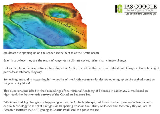
- Scientists have observed that Arctic permafrost above sea level is thawing because of the climate crisis and opening sinkholes on land that damage infrastructure and harm Indigenous communities. For example, instability linked to melting permafrost may have been partially responsible for a massive oil spill in a Russian river in 2020. However, not all Arctic permafrost is above the ground. Some of it was submerged by melting glaciers and sea level rise at the end of the last ice age some 12,000 years ago.
- When they first began surveys in 2010, the researchers found a rough patch about 110 miles offshore, which corresponded to the former edge of the Pleistocene permafrost. They discovered that during this time new craters emerged in the seabed. The largest was 738 feet long by 312 feet wide by 92 feet deep. That’s as large as a city block containing a six-story building, according to MBARI.
- Why is the Arctic Sea ice declining so significantly?
- Research shows a strong and direct correlation with CO2 emissions. In fact, for every metric ton of CO2 we add to the atmosphere, we lose another three-square meter of sea ice.
- Countries like the US, Canada, Australia and Saudi Arabia are some of the largest contributors to sea ice loss per capita, with Qatar topping the list.
- Global warming means rising temperatures are drying out Arctic forests and making them more susceptible to fires. Intense heat incinerates trees, vegetation and any woodland creatures unable to escape the flames, while allowing the carbon stored in branches and tree trunks to escape.
- According to the research, published in the journal Nature Communications, melting permafrost caused by accelerating Arctic warming would add close to $70 trillion to the overall economic impact of climate change if the planet warms by 3°C by 2100.
- The less multi-year ice there is, the less the Arctic is able to regulate the global climate by reflecting sunlight back into space. Without ice, or with very thin ice, the Arctic Ocean instead absorbs the sun’s heat, which inhibits ice formation the following winter - and the downward spiral continues.
- Permafrost thaw contributes to a positive feedback loop that further accelerates the warming of Earth, releasing methane, which is a more powerful greenhouse gas than carbon, directly into the atmosphere, and contributing to the spread of devastating Arctic wildfires.
- Permafrost thaw also destabilizes the ground above it, damaging critical infrastructure, causing unprecedented flooding, and displacing entire communities. Soil that was once frozen year-round is now thawing and refreezing each year.
- When the ground thaws, the soil contracts and sinks, and when it freezes again it expands and rises. This continuous cycle shifts, displaces, and breaks whatever lies above it – roads, railroad tracks, pipes, buildings, and more.
- Instead of storing food in the frozen ground for months, a strategy that has been practiced for thousands of years, community food stocks are now at risk of rotting, creating further food insecurity in an already at-risk area.
- Many Arctic Indigenous communities also face displacement from their traditional homelands. In Alaska, more than 30 communities face an imminent risk of displacement and need for relocation away from erosion and floods – an endeavour that costs millions of dollars and further contributes to housing insecurity in the region.
- In Russia, villages are usually not moved, and Indigenous residents are often forced to relocate to cities – a jarring and traumatic experience for people who have lived off the land for generations. Such forced migrations from rural villages to urban agglomerations strain intergenerational knowledge, language, and traditions exchange that have already been damaged by discriminatory policies.
- Melting Arctic Sea ice is likely to increase traffic through the Arctic Ocean. An early study by James Hansen and colleagues suggested in 1981 that a warming of 5 to 10 °C, which they expected as the range of Arctic temperature change corresponding to doubled CO2 concentrations, could open the Northwest Passage.
- Sea ice decline has been linked to boreal forest decline in North America and is assumed to culminate with an intensifying wildfire regime in this region. The annual net primary production of the Eastern Bering Sea was enhanced by 40–50% through phytoplankton blooms during warm years of early sea ice retreat.
- As arctic ice decays, microorganisms produce substances with various effects on melting and stability. Certain types of bacteria in rotten ice pores produce polymer-like substances, which may influence the physical properties of the ice.
- The polar vortex is a whirlwind of especially cold, dense air forming near the poles that is contained by the jet stream, a belt of fast-flowing winds that serves as a boundary between cold polar air and the warmer air of other hemispheres. Because the power of the polar vortex and jet stream is derived partly from the temperature contrast between cold polar air and warmer tropical air, it is at risk of becoming severely diminished as this contrast is eroded by the effects of melting sea ice.
- Fast mitigation at scale can still slow future Arctic warming, starting with immediate cuts to the short-lived climate pollutants—black carbon, methane, tropospheric ozone, and hydrofluorocarbons. Cutting emissions of these short-lived pollutants immediately can reduce the rate of Arctic warming by up to two-thirds.
- Fast cuts to carbon dioxide also are important, but over the next two decades they will actually add to warming. This is because co-emitted cooling aerosols from fossil fuels like coal wash out of the atmosphere in days to weeks and unmask existing warming, while much of the carbon dioxide remains in the atmosphere for hundreds of years to continue causing warming.
- It also requires speeding up strategies to remove carbon dioxide we’ve already emitted, including natural processes that use photosynthesis to pull carbon dioxide from the atmosphere and store it in trees, grasslands, wetlands, and other biomass, while using the root systems to rebuild soil carbon.
- Other strategies for capturing and utilizing carbon dioxide in products are getting ready to move to commercial scale, meaning that costs would drop rapidly.
- While riskier, another geoengineering strategy involves the introduction of cooling particles into the atmosphere to reflect solar radiation back to space, as observed following the 1991 volcanic eruption of Mt. Pinatubo in the Philippines.
- Solar geoengineering may be able to cut half the warming from a doubling of carbon dioxide, according to the results of an idealized model experiment that showed this could be done without exacerbating temperature, water availability, extreme temperature, or extreme precipitation in any region.
- Finally, we need a crash program to speed mechanical means of direct air capture of carbon dioxide, as many leading scientists and climate experts are advocating. With the need to remove up to a trillion (1,000 billion) tons of carbon dioxide over the century, this will be a whale of a market opportunity.
- Time is of the essence, and speed must become the new metric for measuring all climate strategies. We need to know how fast a given strategy can reduce warming in the near term, and go all out with the fastest. As General MacArthur said of the history of war, defeat can be summed up in two words: “Too late.” We don’t want that to be the epitaph for our generation.
Genesis
- Today’s India has greater agency in shaping diplomacy around crises, unlike in the past. For example, India was publicly supportive of the erstwhile Soviet Union’s invasion of Afghanistan in 1979, while a disapproving Indira Gandhi simultaneously sought a regional strategy against the occupation. Neither approach altered the Soviet state’s behaviour.
- Today, with an economy half the size of India’s, it would have been difficult for Russia to ignore India’s demand for the creation of a humanitarian corridor to evacuate its civilians. Russia heeded to India’s demands and helped repatriate about 22,500 citizens (24 percent of Ukraine’s international students are Indians).
- The world quietly acknowledged the realism underlying India’s diplomatic and logistical response to the crisis. Now that the students have safely repatriated, this phase of Indian diplomacy has run its course.
- India couldn’t have tilted towards both parties at the same time, thus it aimed to remain neutral. India called for a “dialogue,” “cessation of violence,” and “safety” and “safe exit and return” of Indian nationals.
- Following that, India shifted its position, making references to the “UN Charter,” “international law,” and “sovereignty and territorial integrity of states.” Modi reiterated his call for “cessation of the conflict” and expressed “deep concern” for the safety and security of Indian students. In contrast, in his interaction with Zelensky, Modi called for “cessation of violence” and thanked Zelenskyy for Ukraine’s help in securing the safe exit of Indians.
- Even as it tilted a little towards Ukraine, India still won Russia’s approval of its “independent” position, while also securing the US’ acknowledgement as it referred to India’s relationship with Russia as “distinct” and “okay”. The US State Department also recalled a cable asking the US diplomats to relay it to their Indian and Emirati counterparts that their countries’ “neutral” stand on Ukraine places them in “Russia’s camp”.
- Even with negative views, the media support for India was immense. The New York Times stated that India would need to weigh against “geostrategic considerations, particularly with the relationship to China,” While Foreign Policy sympathised with India’s “difficult diplomatic position,” AP noted India was “reducing its dependency on Russian arms and diversifying its defense procurements.”
- The Ukraine war complicates India’s ties with Russia.
- According to the Stockholm International Peace Research Institute, between 2017–2021, Russia’s share of India’s defence imports was 46 percent and India received 28 percent of Russia’s defence exports. Even without sanctions, Russia will divert arms from exports to the Ukraine war, making it harder for India to procure Russian equipment.
- To meet shortages, Russia has asked China for military equipment. If Russia’s military supplies and technology transfers to India were halted without matching supplies from the West, the putative coalition to balance China will be put in jeopardy.
- All too often we talk about India’s defence relationship with Russia. Legacy is merely warm air on cold facts; for example, during 1971, the Soviets acted on their own interests, not India’s, and initially didn’t support India going to war with Pakistan. The Soviets “withheld a positive response to India’s new request for arms till after the Simla Summit” to prevent Indian territorial gains in Kashmir. As Soviet and American interests aligned, India declared a ceasefire after Pakistan’s defeat in the east, ending the war.
- India’s offer to mediate and secure a peaceful resolution received American and Ukrainian support, but not Russian, which maintained control over the narrative. In welcoming India’s stand, Moscow merely made a statement. India attaches a great importance to its ties to Russia.
- The US imposing sanctions on Russia will disrupt Russia’s defence supplies to India. Sanctions could jeopardise exports of S-400 missiles, leasing of Akula class submarines, manufacturing of A-203 rifles, and exports of the BrahMos missile by India. Sanctions will impact existing relationships.
- In sanctioning India under the Countering America’s Adversaries Through Sanctions Act (CAATSA), the US would need to consider “geostrategic considerations, particularly with the relationship to China. However, this was prior to the war, we don’t know what will happen in future.
- Perhaps there will be a pause on sanctions knowing the US defence exports to India are increasing. From next to nothing in 2008, the US defence exports to India rose to US$ 15 billion in 2019. Between 2017-2021 the US is the third largest defence supplier to India, with 12 percent of market share.
- Furthermore, ruthless enforcement of sanctions will increase Russian dependence on China, weakening the US’ relationships with Russia and India. We should be pivoting out of Europe to deal with China. “The Russians are part of our balancing coalition against China.”
- Europe and the Indo-Pacific are now a single strategic system joined by the actions of Putin and Xi. The shift in the US focus to Europe away from the Indo-Pacific is perilous for an India that is facing China.
- Weakening Russia undermines the US’s Indo- Pacific strategy. Beijing could launch provocations in the South China Sea or even along the line of actual control with India.
- China and Russia have resolved to resist “attempts by external forces to undermine security and stability in their common adjacent regions,” meaning Taiwan and Ukraine. China might have nodded at the Russian invasion, if not encouraging it. Moscow’s economic dependence on China undermines the multipolarity India seeks. Dispersing power beyond the US and China is easier said than done.
- Though India has disapproved the infringement of territorial integrity and sovereignty of a country, it has used a different language to describe Russian action individually or at the UN. The rest three countries are on exactly the opposite plane vis-à-vis the Ukrainian crisis. This leads to a few questions.
- The Quad has been constituted as a Mini lateral grouping dealing with the strategic issues of the Indo-Pacific. Quad’s informal mandate is limited to the Indo-Pacific and challenges posed to the regional order. The basic purpose of forging such a forum is to allow members to have the freedom to exercise strategic autonomy.
- Unlike alliances that put restrictions on allies’ freedom to take independent strategic decisions, the Mini laterals, by their structural constitution, inherently allow members to have divergent views on important international issues. Since the Ukrainian crisis does not have a direct bearing on the Indo-Pacific, it is best left outside the mandate of the Quad.
- Moreover, despite divergent views, the Quad met, discussed the Ukrainian crisis, and concluded a joint readout that speaks aloud about its health. The joint statement is a testimony to the fact that Quad partners respect each other’s sensitivities, understand the purpose of the minilateral and have, so far, not mixed regional issues with that of extra-regional developments.
- India has always stood up for the principles enshrined in the UN Charter and abided by the international law not only through words but also through deeds, whether it is the peaceful resolution of the maritime dispute between India and Bangladesh according to the Permanent Court of Arbitration, the Hague, judgement in 2014 or selling the BrahMos to the Philippines according to the Missile Technology Control Regime guidelines.
- However, when a country takes a stand at the international high-table, it considers the entirety of the situation where interests, values and history work in tandem rather than any one of these elements working in isolation.
- A diversity of views regarding the means is acceptable as far as there is convergence at the ends. India has always stood for the normative order. Moreover, the Quad has clearly expressed its commitment to the principles of sovereignty and territorial integrity in the Indo-Pacific. Beyond that, the Quad had little agency to impact the events in the far-away conflict zone.
- In a way, the crisis is a test of Quad’s resilience. So far, the joint statement suggests that there is a common understanding among the Quad members as to how far it would be prudent to drag the Quad in the Ukrainian crisis. Furthermore, it is likely to draw US’ attention back to the Euro-Atlantic theatre. Although the US has refuted such a notion by saying that it can “chew the gum and walk at the same time”, it is difficult to effectively look after a two-front situation if any exigency arises in the Indo-Pacific.
- When the Euro-Atlantic theatre has become the primary area of focus for the US, it is in the region’s interest to have a strong and cohesive Quad. Moreover, the US’ Indo-Pacific strategy has accepted that “a successful Indo-Pacific vision must advance freedom and openness and offer ‘autonomy and options. Therefore, it looks improbable that the Ukrainian crisis will have any inadvertent impact on the functioning of the Quad.
- However, if the US decides to impose sanctions on India over its defence ties with Russia, that will likely have unwarranted effects on the Quad. Although India has done exceptionally well in walking on a tightrope during the Ukrainian crisis, it may come under pressure from the Quad countries in the future to take a fresh look at its position on the Ukrainian crisis.
- New Delhi should keep taking decisions based solely on the national interest. India’s position on international matters should be delinked with its standing in the Quad since the existence of the minilateral is conjoint with particular issues in a defined geography.
- Thus, India can only tilt towards itself; this is a constant realisation and reminder. With the prospect of greater pressure from China, not only in Taiwan but also in Ladakh—some say, China will draw lessons from Ukraine to declare Pakistan Occupied Kashmir independent at an opportune time in future—India needs to introspect on strategy and means.
- As the Himalayan snows melt, India must make a move of high deterrence value. India’s diplomacy must relentlessly employ Russia as a moderating influence on China, and the US as a countervailing partner.
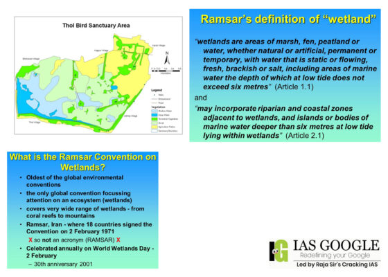
Thol Lake
- Thol lake was designated by Ramsar Convention as a wetland of international importance.
- Located 40 km west of Ahmedabad city, Thol was constructed for irrigation in 1912. In 1988, it was declared as a wildlife sanctuary by the state government to protect the birdlife found in this open-water wetland site.
- It is on the Central Asian Flyway and more than 320 bird species can be found, making up some 57% of all the bird species of Gujarat. More than 110 waterbird species have been recorded, about 43% of India’s waterbird species, with almost 30% of those species being migratory waterbirds.
- More than 30 of the waterbirds are threatened, such as the critically endangered white-rumped vulture (Gyps bengalensis) and sociable lapwing (Vanellus gregarius), and the vulnerable sarus crane (Grus antigone), common pochard (Aythya farina) and lesser white-fronted goose (Anser erythropus).
- This wetland regularly hosts more than 1% of the population of species including glossy ibis (Plegadis falcinellus). It is also essential during the dry seasons for a population of blackbuck (Antilope cervicapra) and other mammals in the surrounding area.
- The Lake provides water for drinking and irrigation and enables groundwater recharge,” Ramsar secretariat further records as the reason for annotating Thol on the list of Wetlands of International Importance.
- Gujarat Urban Development Company Limited (GUDC), a state government undertaking for executing urban infrastructure projects, had floated tenders for this STP having capacity to treat 33.10 million litres per day (MLD). Five firms have submitted tenders as of March 9 when the tender was closed for the project, and the project is estimated to cost Rs 46.64 crore.
- The forest department gave the green light to the project on the condition that discharge of treated wastewater from the STP shall not disturb routine birdlife in Tholand that periodic water quality testing reports shall be submitted to the forest department.
- For now, the proposed STP will treat 15 MLD of wastewater generated by Kalol and around two MLD generated by thousands of residents of Kalol-Ola-Borisana and Kalol-Saij-Borisana areas of AUDA but capacity utilisation will go up as population increase in future.
- The STP, which will be funded by the central government under the Atal Mission for Rejuvenation and Urban Transformation (AMRUT), will discharge treated wastewater into Saij-Hajipur water channel running through Moti Bhoyan and Karoli villages and eventually draining into Thol lake via the Eastern Drain.
- A man-made water canal, the Eastern Drain is one of the 21 drains dug more than a century ago to channel and store runoff in Mehsana district.
- At least four government agencies—the GUDC, forest department, irrigation department and the Gujarat Pollution Control Board, will have to work together now to ensure the water quality in Thol lake remains conducive to its ecology and wildlife.
- Besides the Eastern Drain, it is also fed by two minor drains — Saij-Hajipur kans and Irana-Indrap-Vamaj kans. But the lake has since turned into an important wildlife habitat, especially for waterbirds, including dozens of species of international migratory birds as it falls on the Central Asian Flyway.
- Releasing waste water into a wetland without treatment or even with insufficient treatment can prove hazardous for the wetland.
- If the wastewater is in the form of untreated domestic sewage, it may lead to accelerated eutrophication (nutrient enrichment) owing to the excessive concentration of nutrients like phosphates and nitrates.
- It may further lead to algal blooming which may further cause aesthetic deterioration, dissolved oxygen depletion and fish kill.
- Dark-grey wastewater streaming from Kalol town every day flows into this oxidation pond through small channels, creating froth on the pond surface.
- Kalol municipality does not have any facility to treat domestic sewage and therefore around 15 MLD of untreated wastewater flows into the pond near PSM Hospital and from there, through agricultural field, ends up in water channels which lead to Thol lake, 20 kilometers downstream.
- Where industrial waste water is being used for irrigation, for example on farms located near industrial clusters, there is increasing evidence of crop contamination with heavy metals.
- Groundwater is also polluted as a result of indiscriminate industrial dumping, causing freshwater scarcity in the region.
- The Ramsar Convention on wetlands, which came into existence in 1971, is an intergovernmental treaty that provides the framework for national action and international cooperation for the conservation and wise use of wetlands and their resources.
- The Ramsar Convention works closely with six other organisations known as international organization partners (IOPs). These are:
- Bird Life International
- International Union for Conservation of Nature (IUCN)
- International Water Management Institute (IWMI)
- Wetlands International
- WWF International
- Wildfowl & Wetlands Trust (WWT)
- It is like an ISO certification. They can take you off the list as well if you don’t meet their standards continuously.
- Ramsar tag makes it incumbent upon authority to strengthen the protection regime there and also creates defences against encroachment etc on wetlands.
- Nal Sarovar Bird Sanctuary and Thol Wildlife Sanctuary, both Ramsar Sites, are examples of sustainable and wise use of wetlands as they provide livelihood to locals besides supporting around 100 species of waterfowl.
- They are among the world’s most productive environments; cradles of biological diversity that provide water and productivity upon which countless species of plants and animals depend for survival.
- They provide humanity, ranging from freshwater supply, food and building materials, and biodiversity, to flood control, groundwater recharge, and climate change mitigation.
- Sustainable industrialisation has a critical role to play in water governance. The 2014 Intergovernmental Panel for Climate Change highlighted how industrial symbiosis within special economic zones and industrial clusters could be an effective laboratory for innovative pollution-mitigation strategies.
- Continued sustainable development in the resource-constrained state will require a comprehensive water-conservation blueprint that integrates environmental protection into industrial activities. If Gujarat succeeds, it could set a precedent for the rest of the country.
About Jaisalmer’s Desert Foxes
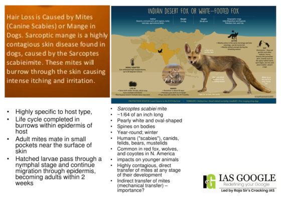
- The Desert Fox, also known as the White-footed Fox (Vulpes vulpes pusilla) is the most widely distributed carnivore in the world.
- It is a small, Asiatic subspecies of Red Fox that ranges through most of the north-western Indian subcontinent, Pakistan's desert districts, Baluchistan, southern Iran, and Iraq.
- Desert foxes can be found wandering around sand dunes and semi-dried river beds, where they build their dens. They are no bigger than a house cat, with a long, bushy tail.
- Their coats are a mix of sandy, white, and grey, with darker shadings and markings—the perfect camouflage in the desert environment. They can be differentiated from other fox species by their white tail-tip.
- There were 8,331 foxes — both Indian and desert foxes — in the state according to the 2019 wildlife census of Rajasthan.
- There were 6,715 in the territorial area and 1,616 in protected areas. There were 386 foxes in the Desert National Park (DNP) and 317 outside it in Jaisalmer.
- Desert fox can be seen in the Desert National Park and Tal Chhapar Sanctuary (specially the Guashala region) in Rajasthan. Gujarat’s Wild Ass Wildlife Sanctuary, in the Little Rann of Kutch, also hosts the desert fox.
- Cultivation and urbanization of lands has reduced their habitat areas and that threat will only get worse in the future. One of the biggest threats the desert fox faces is disease from domestic animals like dogs, which prove fatal to them.
- Like most other species, foxes too have been affected by habitat loss, but fortunately, their habitat is varied and they are extremely adaptive.
- There are many cases of them suffering from Sarcoptic Mange. The very first-time spotted mange in the desert fox was in 2006.
- Sarcoptic mange is caused by the parasitic mite Sarcoptes scabiei. When the infected animal scratches and the skin breaks, it lays eggs and multiplies. The affected area becomes scabbed and no hair grows there.
- The major areas of infection are Sanvtha, Nedan, Sanavada, Lathi, Bhadariya, Odhaniya-Chacha, Dholiya (all in Pokhran block) and Sam, Sudasari, Ganga, Bidha, Jamra, Nimba, and few surrounding areas (all in Desert National Park).
- The disease is self-limiting “so there’s hardly any chance of rapid mass spread in the wildlife population.
- The disease spreads from one individual to another and we have been spotting 8-10 infected individuals every year, which clearly indicates that the disease is spreading. According to my estimates, it might have spread to over 30 per cent individuals in Jaisalmer district.
- Additionally, it is attainable that they acquired it from stray canines who dwell in villages.
- Though sarcoptic mange is curable, it can be fatal if left untreated. Severely infected individuals end up losing their lives because of the intense itching caused by the mites, a lack of appetite to hunt and maggot infestations on the deep wounds that result from continuous scratching.
- After death, the carcass of impacted individuals may further spread the disease if/ when live animals come in contact with the same.
- Apart from being a threat to wildlife in the region, sarcoptic mange can also have an impact on the livelihoods of local communities. Camel and cow rearing for milk is a staple source of income in the region but sarcoptic mange disease outbreaks in camels have been causing deaths and there is a consequent loss of income to communities.
- The disease has already been reported to affect three species in the region - desert foxes, camels and village dogs.
- The only way to treat them is to catch them. As suggested, the mixing of the medicine in water bodies where these foxes drink from is not a good solution as other animal’s drink from the same water bodies and if they drink too much water, it may cause an overdose of the medicine in the animals too.
- Mange treatment given to captive foxes is usually successful, involving doses of Stronghold 5 -10kg or two injections of Ivomec or Panomec (.125ml) given over a two-week period. Both treatments are best applied in conjunction with a broad-spectrum antibiotic such as Baytril or Synulox to combat skin infection.
- Providing you can obtain veterinary support, Ivomec or Panomec may be applied orally, in food. However, these treatments may be dangerous to pets and other species.
- The incubation period (i.e. period from exposure to the development of observable signs or lesions) is dependent on host and the quantity of mite exposure.
- While clinical signs can be suggestive of mange, confirming the disease in individual animals requires one of the following techniques: cytology/histology to identify mites and describe the associated pathology, detection of antibodies in the serum, and/or molecular techniques.
- Several approaches can be used to investigate mange and mite exposure in populations. Serological tests can be useful to determine previous exposure to S. scabiei, but may not differentiate past exposure with current clinical disease.
- Similarly, its usefulness for individuals can be limited due to unknown time of initial exposure, possible differences in individual immune responses, and unknown applicability for commercially available assays for use in wildlife species.
- The Desert National Park (DNP) covers an area of 3162 km² of which 1900 km² is in Jaisalmer district and remaining 1262 km² is in Barmer district of Rajasthan State.
- Desert National Park is a national park situated in the Indian state of Rajasthan, near the towns of Jaisalmer and Barmer. This is one of the largest national parks, covering an area of 3162 km².
- The Desert National Park is an excellent example of the ecosystem of the Thar Desert. Sand dunes form around 20% of the park. The major landform consists of craggy rocks and compact Salt Lake bottoms, intermedial areas and fixed dunes.
- Despite a fragile ecosystem, there is an abundance of birdlife. The region is a haven for migratory and resident birds of the desert.
- Many eagles, harriers, falcons, buzzards, kestrels and vultures are spotted here. Short-toed eagles, tawny eagles, spotted eagles, laggar falcons and kestrels are the most common among these.
- Sand grouses are spotted near small ponds or lakes. The endangered great Indian bustard is a magnificent bird found in relatively fair numbers. It migrates locally in different seasons. The most suitable time to visit the area is between November and January.
- The Desert National Park has a collection of fossils of animals and plants which is 180 million years old. Some fossils of dinosaurs which are 60 million years old have been found in the area.
- The endangered Indian bustard is the major attraction of Desert National Park. Brown and white in colour, the bustard is a meter tall and has long bare legs and a long neck. One can spot this tall and graceful ground-dwelling bird near the Sudashri waterhole.
What are the GSAT 7 series satellites?
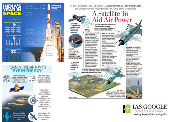
- GSAT 7 satellites are advanced satellites developed by the Indian Space Research Organisation (ISRO) to meet the communication needs of the defence services. The GSAT 7 satellite was launched in August 2013 from an Ariane 5 ECA rocket from Kourou in French Guiana.
- It is a 2,650 kg satellite which has a footprint of nearly 2,000 nautical miles in the Indian Ocean region. This satellite is mainly used by the Indian Navy for its communication needs.
- The GSAT 7 provides a gamut of services for military communication needs, which includes low bit voice rate to high bit rate data facilities, including multi-band communications. Named Rukmini, the satellite carries payloads in UHF, C-band and Ku-band, and helps the Navy to have a secure, real time communication link between its land establishments, surface ships, submarines and aircraft.
- The satellite was injected into a geosynchronous transfer orbit (GTO) of 249 km perigee (nearest point to earth), 35,929 km apogee (farthest point to earth) and an inclination of 3.5 degree with respect to the equator.
- The GSAT 7B will primarily fulfil the communication needs of the Army. Currently, the Army is using 30 per cent of the communication capabilities of the GSAT 7A satellite, which has been designed for the Indian Air Force (IAF).
- The GSAT 7B will also help the Army enhance its surveillance in border areas. While many features of this satellite are still a closely guarded secret, it is expected that the state of the art, multi-band, military-grade satellite shall be a shot in the arm for the communication and surveillance needs of the Army.
- The indigenous communication satellite for the Army, GSAT 7B, when launched, will majorly benefit the unmanned aerial vehicles (UAVs) in the force’s inventory by ensuring they have an enhanced flying range in line with their original specifications.
- As per the Army, this will be a state-of-the-art, multiband, military-grade satellite, which will be a force multiplier in providing fail-safe communication support.
- These satellites, exclusive to the military, are for communications, even as a range of other Indian satellites as well as those of foreign countries are used for Intelligence-Surveillance Reconnaissance (ISR) purposes.
- Defence sources said the satellite, once launched, will enable the Army to secure communications between far-off locations, thus boosting the network-centric warfare capabilities of the force.
- While these dedicated satellites will be used for communication purposes, there are over half a dozen satellites also used for military needs, including the Cartosat and Risat (Radar Imaging Satellite) series of satellites.
- Acquisition of these equipment and systems will enhance operational preparedness of armed forces by providing better visibility, enhanced mobility, improved communication and increased capability of detecting enemy aircraft.
- The GSAT 7A was launched in 2018 from the Satish Dhawan Space Centre in Sriharikota, and has gone a long way in boosting the connectivity between the ground radar stations, airbases and the airborne early warning and control aircraft (AEW&C) of the IAF.
- It also helps in satellite-controlled operations of unmanned aerial vehicles (UAVs) which gives a great deal of reliability to the operations as compared to ground-controlled operations.
- This satellite has 10 channels in Ku band with switchable frequency for mobile users, one fixed Gregorian or parabolic antenna, and four steerable antennae.
- A GSAT 7C satellite is on the cards for the IAF, and a proposal to this effect was cleared by the DAC in 2021. This satellite would facilitate real time communication with IAF’s software defined radio communication sets. It will increase the capability of the IAF to communicate beyond the line of sight in a secure mode.
- An Electromagnetic Intelligence Gathering Satellite (EMISAT), developed by ISRO, was launched in April 2020 through a Polar Satellite Launch Vehicle (PSLV-C45). It has an Electronic Intelligence (ELINT) package called Kautilya, which allows the interception of ground-based radar and also carries out electronic surveillance across India.
- The ELINT package provides the capability in direction-finding of radar and fixing their locations. It is placed in a 748-km orbit, and is said to be based on the Israeli satellite system. This satellite circles the globe pole-to-pole, and is helpful in gathering information from radars of countries that have borders with India.
- India also has a RISAT 2BR1 synthetic aperture radar imaging satellite, which was launched in December 2019 from Sriharikota. It has the capability to operate in different modes including very high-resolution imaging modes of 1×0.5-meter resolution and 0.5×0.3 m resolution with a swath of 5-10 km.
- Technology Experiment Satellite or (TES) is an experimental satellite to demonstrate and validate, in orbit, technologies that could be used in the future satellites of Indian Space Research Organisation (ISRO). The Technology Experiment Satellite (TES) has a panchromatic camera capable of producing images of 1 meter resolution for remote sensing. The launch of TES made India the second country in the world after the United States that can commercially offer images with one meter resolution. It is used for remote sensing of civilian areas, mapping industry and geographical information services.
- CARTOSAT-2 carries a state-of-the-art panchromatic (PAN) camera that takes black and white pictures of the earth in the visible region of the electromagnetic spectrum. The swath covered by these high-resolution PAN cameras is 9.6 km and their spatial resolution is 80 centimeters. The satellite can be steered up to 45 degrees along as well as across the track.
- CARTOSAT-2 is an advanced remote sensing satellite capable of providing scene-specific spot imagery. The data from the satellite will be used for detailed mapping and other cartographic applications at cadastral level, urban and rural infrastructure development and management, as well as applications in Land Information System (LIS) and Geographical Information System (GIS).
- CARTOSAT-2A is a dedicated satellite for the Indian Armed Forces. The satellite carries a panchromatic (PAN) camera capable of taking black-and-white pictures in the visible region of electromagnetic spectrum. The highly agile Cartosat-2A can be steered up to 45 deg along as well as across the direction of its movement to facilitate imaging of any area more frequently.
- CARTOSAT-2B carries a panchromatic (PAN) camera capable of taking black-and-white pictures in the visible region of electromagnetic spectrum which has a resolution of 80 centimeters. The highly agile CARTOSAT-2B can be steered up to 45 deg along as well as across the direction of its movement to facilitate imaging of any area more frequently and offers multiple spot scene imagery.
- GSAT-6A is a dedicated satellite for the army as a replacement for GSAT-6 which lost communication after its launch.
- GSAT-7 was launched in 2013 for the exclusive use of the Indian Navy to monitor the Indian Ocean Region (IOR) with the satellite’s 2,000 nautical mile ‘footprint’ and real-time input capabilities to Indian warships, submarines and maritime aircraft. To boost its network-centric operations, the IAF is also likely to get another satellite GSAT-7C within a few years.
- HySIS, a dual use satellite, was also launched in November 2013, which is used by the navy. HySIS carries two payloads, the first in the Visible Near Infrared (VNIR) spectral range of 0.4 to 0.95 micrometers with 60 contiguous spectral bands and the second in the Shortwave Infrared Range (SWIR) spectral range of 0.85 to 2.4 micrometers with a 10-nanometre bandwidth and 256 contiguous spectral bands. The satellite will have a spatial resolution of 30 meters and a swath of 30 km from its 630 km sun-synchronous orbit.
- The Integrated Space Cell was the nodal agency within the Government of India which oversees the security of its space-based military and civilian hardware systems.
- It was to be jointly operated by all the three services of the Indian Armed Forces, the civilian Defence Research and Development Organisation and the Indian Space Research Organisation (ISRO). This agency was Superseded by Defence Space Agency.
- As of 2018, the IRS system is the largest constellation of remote sensing satellites for civilian use in operation today in the world which also has dual military use, with 14 operational satellites including the latest at least 4 dedicated military use (GSAT-7, GSAT-6 and GSAT-7A, EMISAT by DRDO), however GSAT-6A which was launched as a dedicated satellite for army lost communication after its launch, and HySIS and Microsat-R satellites as of 24 January 2019 are dual-use satellite available to the military also.
- Of the 900+ operational satellites, there are 320 dual-use or dedicated military satellites in the sky, half of which are owned by the USA alone, followed by Russia, China and India (14).
- As part of the Aatmanirbhar Bharat initiative, Defence Acquisition Council has approved the acquisition of a state of the art, multiband, military-grade satellite for the Indian Army. The satellite will be a force multiplier in providing fail-safe communication support.
Key Findings
- Moradabad has recorded noise pollution of a maximum of 114 decibels (db). The Frontier 2022 report mentions a total of 61 cities.
- The highest noise pollution of 119 db has been recorded in Dhaka, the capital of Bangladesh. At third place is Pakistan’s capital Islamabad, where the noise pollution level has been recorded at 105 db.
- The report identifies 13 noise polluted cities in south Asia. Five of these, including Moradabad, are in India, which have recorded alarming levels of noise pollution:
- Kolkata (89 db)
- Asansol (89 db)
- Jaipur (84 db)
- Delhi (83 db)
- Noise pollution is generally defined as regular exposure to elevated sound levels that may lead to adverse effects in humans or other living organisms.
- According to the World Health Organization, sound levels less than 70 dB are not damaging to living organisms, regardless of how long or consistent the exposure is. Exposure for more than 8 hours to constant noise beyond 85 dB may be hazardous.
- If you work for 8 hours daily in close proximity to a busy road or highway, you are very likely exposed to traffic noise pollution around 85dB.
- Sounds with a frequency over 70 db are considered harmful to health.
- Street traffic sounds from cars, buses, pedestrians, ambulances etc.
- Construction sounds like drilling or other heavy machinery in operation
- Airports, with constant elevated sounds from air traffic, i.e. planes taking off or landing
- Workplace sounds often common in open-space offices
- Constant loud music in or near commercial venues
- Industrial sounds like fans, generators, compressors, mills
- Household sounds, from the television set to music playing on the stereo or computer, vacuum cleaners, fans and coolers, washing machines, dishwashers, lawnmowers etc.
- Events involving fireworks, firecrackers, loudspeakers etc.
- Conflicts generate noise pollution through explosions, gunfire etc. The dysfunctions, in this case, are likely caused by conflict and insecurity and less by noise pollution in itself, although that compounds stress levels too.
- High levels of noise pollution affect human health and well-being by having an effect on sleep. This has a bad effect on the communication of many animal species living in the area and their ability to hear.
- Regular exposure for eight hours a day to 85 decibels of sound can permanently eliminate the ability to hear. Not only that, exposure to relatively low noise pollution for long periods in cities can harm physical and mental health.
- According to the report, long-term exposure to noise pollution in Europe causes 12,000 premature deaths annually, 48,000 new cases of heart disease and 22 million people suffer from irritability.
- A study in Korea showed that a 1 decibel increase in daytime sound increased the risk of cardio (heart) and cerebrovascular (related to blood flow to the brain) diseases by 0.17 to 0.66 per cent.
- Hypertension is, in this case, a direct result of noise pollution caused by elevated blood levels for a longer period of time.
- Children appear to be more sensitive to noise pollution, and a number of noise-pollution-related diseases and dysfunctions are known to affect children, from hearing impairment to psychological and physical effects.
- Also, children who regularly use music players at high volumes are at risk of developing hearing dysfunctions. In 2001, it was estimated that 12.5% of American children between the ages of 6 to 19 years had impaired hearing in one or both ears.
- Dementia isn’t necessarily caused by noise pollution, but its onset can be favored or compounded by noise pollution.
- Psychological dysfunctions and noise annoyance. Noise annoyance is, in fact, a recognized name for an emotional reaction that can have an immediate impact.
- Our oceans are no longer quiet. Thousands of oil drills, sonars, seismic survey devices, coastal recreational watercraft and shipping vessels are now populating our waters, and that is a serious cause of noise pollution for marine life.
- Whales are among the most affected, as their hearing helps them orient themselves, feed and communicate.
- Noise pollution thus interferes with cetaceans’ (whales and dolphins) feeding habits, reproductive patterns and migration routes, and can even cause hemorrhage and death.
- Other than marine life, land animals are also affected by noise pollution in the form of traffic, firecrackers etc., and birds are especially affected by the increased air traffic.
- The World Health Organization estimates that one out of three people in Europe is harmed by traffic noise. More than the purely medical effects of noise pollution on the individual, there is a significant social and economic impact.
- Since noise pollution leads to sleep disturbance, it affects the individual’s work performance during the day, it leads to hypertension and cardiovascular disease and costs the health system additional time and money, and it negatively affects school performance in children.
- The World Health Organization (WHO) had recommended a 55 db standard for residential areas in the 1999 guidelines, while for traffic and business sectors, the limit was 70 db.
- The WHO set the limit of noise pollution on the road at 53 db in 2018, taking into account health and safety.
- Measures taken to reduce noise pollution in metropolitan cities include advisories for noise monitoring on the occasion of Deepawali, prohibition of the use of fireworks between 10 PM and 6 AM, awareness programme to avoid bursting of firecrackers and issuance of directions under relevant sections of the Environment (Protection) Act, 1986.
- Central Pollution Control Board (CPCB) in association with its counterparts in every state carries out monitoring of noise pollution in seven metropolitan cities -- Mumbai, Delhi, Kolkata, Chennai, Bangalore, Lucknow and Hyderabad through a network of 70 noise-monitoring stations under National Ambient Noise Monitoring Programme (NANMP).
- Article 48 A under the Directive Principles of State Policy, which are regarded as fundamental to governance of the country, mandated that the State shall endeavour to protect and improve the environment, which included providing a pollution-free environment to its citizens. Therefore, it was the duty of the respondents herein to provide the petitioner to have a pollution-free environment.
- Solutions to Reduce Noise Pollution
- International bodies like the WHO agree that awareness of noise pollution is essential to beat this invisible enemy. For example: avoid very noisy leisure activities, opt for alternative means of transport such as bicycles or electric vehicles over taking the car, do your housework at recommended times, insulate homes with noise-absorbing materials, etc. Educating the younger generation is also an essential aspect of environmental education.
- Governments can also take measures to ensure correct noise management and reduce noise pollution. For example: protecting certain areas — parts of the countryside, areas of natural interest, city parks, etc. — from noise, establishing regulations that include preventive and corrective measures — mandatory separation between residential zones and sources of noise like airports, fines for exceeding noise limits, etc. —, installing noise insulation in new buildings, creating pedestrian areas where traffic is only allowed to enter to offload goods at certain times, replacing traditional asphalt with more efficient options that can reduce traffic noise by up to 3 dB, among others.
- Trees have been established to be effective in reducing noise levels within urban settings, around major highways, and even at the places where we stay.
- Therefore, numerous plants and trees in an area mean less noise pollution. In addition to that, trees have various aesthetic advantages and improve air quality.
- Cancelling or masking the noise is one of the most straightforward and practical techniques for reducing noise pollution. It is achieved through the creation of peaceful and soothing sounds to cancel the awful ones.
- Old automobiles are a significant source of noise pollution. They create unappealing and sometimes deafening sounds. Their replacement with new ones not only reduces noise pollution but will also lower the emission of soot and other toxic substances into the atmosphere.
- Creating awareness of noise pollution and its effects on both humans and wildlife can generate positive outcomes in efforts to reduce noise pollution.
- Perhaps if most people could be aware that noise pollution can lead to hearing loss and mental stress, then the majority will invest in ways to reduce noise pollution.
- Horns from trucks, buses, and cars produce a considerable degree of noise pollution and as such, the introduction of no horn zone can help reduce noise pollution in hospitals, schools, and residential areas.
- Government and city authorities hold the power to introduce policies that can help reduce noise pollution. The laws should limit the amount of noise in public and private places to cut noise pollution.
- The policies can also be integrated into transportation network construction and activities such as low-noise road surfaces, low-noise tracks, redesigning street spaces, enforcing speed limits, and reducing traffic volume.
- Development of Silence Zone in the vicinity of Public Places.
- Successful noise management should be based on the fundamental principles of precaution, the polluter pays and prevention. The noise abatement strategy typically starts with the development of noise standards or guidelines, and the identification, mapping and monitoring of noise sources and exposed communities. A powerful tool in developing and applying the control strategy is to make use of modelling. These models need to be validated by monitoring data. Noise parameters relevant to the important sources of noise must be known.
- Noise control should include measures to limit the noise at the source, to control the sound transmission path, to protect the receiver’s site, to plan land use, and to raise public awareness. With careful planning, exposure to noise can be avoided or reduced. Control options should take into account the technical, financial, social, health and environmental factors of concern. Cost benefit relationships, as well as the cost-effectiveness of the control measures, must be considered in the context of the social and financial situation of each country.
POSTED ON 27-03-2022 BY ADMIN
Next previous  General Studies
Political Science and International Relations
Some Reference Essays
List of previous year essay topics (1997-2019)
IAS GOOGLE is googled by the team of Raja Sir’s Cracking IAS Academy. Sources include The Hindu, Indian Express, pib.nic.in, Down To Earth, Economic Times, Vigyan Prasar, AIR and the like. IAS GOOGLE has been prepared in pace with emerging UPSC Trends.