1. The horizontal deflection effect caused by the Coriolis Force is(a) Greater near the pole(b) Greater near the equator(c) Equally Distributed all over the earth’s surface(d) More near the surface of the earth and lesser above2. Which of the following is correct about Coriolis Force?(a) Coriolis Force affects only the large-scale movement of air in the atmosphere(b) Coriolis Effect is caused due to rotation of Earth and pressure difference between two points(c) Winds are deflected to the right in the Southern hemisphere(d) If it was not for the Earth’s rotation, global winds would blow in straight north-south lines3. Sub-Tropical Jet stream flows from(a) West to East in Southern hemisphere(b) East to West in Northern hemisphere(c) East to West in Southern hemisphere(d) West to East in Northern hemisphere4. Which of the following are the constituents of urban area? 1) Statutory Towns2) Census Towns3) Outgrowths 4) Ringroads(a) 1, 2, 3 (b) 1, 3, 4(c) 2, 3, 4(d) 1, 2, 3, 45. What are Zemu, Milam, Cheepa, Newla and Pindari?(a) Glaciers(b) Mountain dwelling Animals(c) Rivers(d) Medicinal herbs and plantsAnswers1.(a)The horizontal deflection effect is greater near the poles and smallest at the equator, since the rate of change in the diameter of the circles of latitude when travelling north or south, increases the closer the object is to the poles.This effect is responsible for the rotation of large cyclones.2. (d)The Coriolis effect is caused by the rotation of the Earth and the inertia of the mass experiencing the effect. Because the Earth completes only one rotation per day, the Coriolis force is quite small, and its effects generally become noticeable only for motions occurring over large distances and long periods of time, such as large-scale movement of air in the atmosphere or water in the ocean.This force causes moving objects on the surface of the Earth to be deflected to the right (with respect to the direction of travel) in the Northern Hemisphere and to the left in the Southern Hemisphere.3. (d)Sub-Tropical Jet stream (STJ) is a narrow band of fast moving air flowing from west to east (Westerlies).STJ in northern hemisphere flows between 25° to 35° N in the upper troposphere at a height of about 12-14 kmph.4. (a)https://censusindia.gov.in/2011-prov-results/paper2/data_files/kerala/13-concept-34.pdf5.(a)Glaciers are a bulk of ice moving under its weight. It forms in areas where the amassing of snow goes beyond its ablation over many years. They are sensitive indicators of changing climate.
They are generally seen in the snow-fields.
This largest freshwater basin covers around10 percent of the land surface of the Earth.
Out of total water on Earth, 2.1% is in glaciers while 97.2% is in the oceans and inland seas.
Condition of glacier formation:
Mean annual temperatures are close to the freezing point.
Winter precipitation produces significant accumulations of snow.
Temperatures throughout the rest of the year do not result in the complete loss of the previous winter’s snow accumulation.
According to the topography and the location of the glacier, it can be categorized as Mountain Glacier (Alpine Glaciers) or Continental Glacier (Ice Sheets).
The Continental Glacier moves outward in all directions whereas the Mountain Glacier moves from a higher to a lower altitude.
Alpine Glaciers
Alpine glaciers are formed on the mountainsides and they usually move downwards through the valleys.
There are times when an alpine glacier also deepens the valleys by pushing away the dirt, soil, and other materials.
These glaciers are found in high mountains.
Ice Sheets
Ice sheets form broad domes and usually spread out in all directions.
When the ice sheets spread, they cover all the areas such as valleys, plains, and mountains with a thick blanket of ice.
The continental glaciers are the largest ice sheets and cover most of Antarctica and islands of Greenland.
Geographical Locationof Glaciers
91% of the Glaciers are in Antarctica and 8% are in Greenland. They occupy about 10% of the world’s total land area.
Glaciers in India
Name
State
Mountain Range
Batura Glacier
Jammu & Kashmir
Karakoram Mountain Range
Khurdopin Glacier
Jammu & Kashmir
Karakoram Mountain Range
Hispar Glacier
Jammu & Kashmir
Karakoram Mountain Range
Biafo Glacier
Jammu & Kashmir
Karakoram Mountain Range
Baltoro Glacier
Jammu & Kashmir
Karakoram Mountain Range
Chomolungma glacier
Jammu & Kashmir
Karakoram Mountain Range
Khurdapin glacier
Ladakh
Karakoram
Godwin Austen
Ladakh
Karakoram
Trango Glacier
Ladakh
Karakoram
Chong Kumdan
Ladakh
Karakoram
Diamir Glacier
Jammu & Kashmir
Karakoram Mountain Range
Siachen Glacier
Jammu & Kashmir
Karakoram Mountain Range
Bara Shigri Glacier
Himachal Pradesh
Pir Panjal Range of the Inner Himalayas.
Chhota Shigri Glacier
Himachal Pradesh
Pir Panjal
Sonapani Glacier
Himachal Pradesh
Pir Panjal
Rakhiot Glacier
Ladakh
Pir Panjal
Gangotri Glacier
Uttarkashi, Uttarakhand
Himalayas
Bandarpunch Glacier
Uttarakhand
Western edge of the high Himalayan range
Milam Glacier
Uttarakhand
Trishul peak of Pithoragarh
Pindari glacier
Nanda Devi, Uttarakhand
Upper reaches of the Kumaon Himalayas
Kafni Glacier
Uttarakhand
Kumaon-Garhwal
Kalabaland Glacier
Uttarakhand
Kumaon-Garhwal
Kedar Bamak Glacier
Uttarakhand
Kumaon-Garhwal
Meola Glacier
Uttarakhand
Kumaon-Garhwal
Namik Glacier
Uttarakhand
Kumaon-Garhwal
Panchchuli Glacier
Uttarakhand
Kumaon-Garhwal
Ralam Glacier
Uttarakhand
Kumaon-Garhwal
Sona Glacier
Uttarakhand
Kumaon-Garhwal
Satopanth Glacier
Uttarakhand
Kumaon-Garhwal
Sunderdhunga Glacier
Uttarakhand
Kumaon-Garhwal
Dokriani Glacier
Uttarakhand
Kumaon-Garhwal
Chorabari Glacier
Uttarakhand
Kumaon-Garhwal
Zemu Glacier
Sikkim
Eastern Himalaya Located on Kanchenjunga peak
Kanchenjunga Glacier
Sikkim
Eastern Himalaya
Glaciers in Himalayas
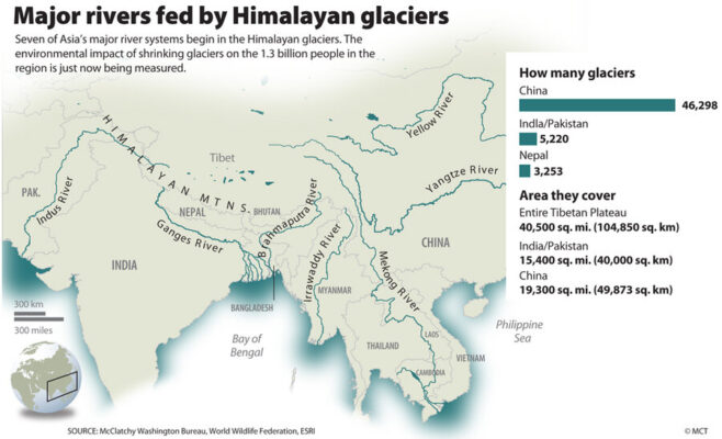
There are about 15,000 glaciers in the Himalayas.
Total area of Himalayas is about five lakh square kilometres (Area of India is nearly 32 lakh sq km). About 33,000 sq km area is covered by snow.
The snow line (the lowest level of perpetual snow) varies in different parts of the Himalayas depending upon latitude, amount of precipitation and local topography.
Glaciers of the Karakoram Range
Maximum development of glaciers occurs in the Karakoram range.
Some of the largest glaciers outside the polar and sub-polar regions are found in this range. The southern side of this range has many gigantic glaciers.
The 75 km long Siachen Glacier in Nubra valley has the distinction of being the largest glacier outside the polar and the sub-polar regions.
The second largest is the 74 km long Fedchenko Glacier (Pamirs)
Third largest is the Hispar Glacier. It is 62 km long and occupies a tributary of the Hunza River.
Glaciers of the Pir Panjal Range
The glaciers of the Pir Panjal Range are less numerous and smaller in size as compared to those of the Karakoram Range.
The longest Sonapani Glacier in the Chandra Valley of Lahul and Spiti region is only 15 km long.
Glaciers of the Kumaon-Garhwal Region
In the Kumaon-Garhwal region of the Himalayas, the largest is the 30 km long Gangotri Glacier which is the source of the holy Ganga.
Garhwal Region
Lying in the Himalayas, it is bounded on the north by Tibet, on the east by Kumaon region, on the south by Uttar Pradesh state, and on the northwest by Himachal Pradesh state.
It includes the districts of Chamoli, Dehradun, Haridwar, Pauri Garhwal, Rudraprayag, Tehri Garhwal, and Uttarkashi.
Glaciers of Central Nepal
Zemu and the Kanchenjunga glaciers are the major ones.
Gangotri Glacier
Largest Glacier in Uttarakhand.
Source of the Ganges. (River Bhagirathi)
The Gangotri glacier originates at the northern slope of Chaukhamba range of peaks in Garhwal Himalayas.
Gangotri is not a single valley glacier, but a combination of several other glaciers.
Carbon Deposits on Gangotri
The Wadia Institute of Himalayan Geology is an Autonomous Institute administered by the Department of Science and Technology.
They have the Chirbasa station at a height of 3,600 m and Bhojbasa station at a height of 3,800 m.
They research the number of carbon deposits on the important glaciers of the Himalayas. Gangotri being the source of the Ganges is one of the most important Glaciers in the country.
According to recent data from the research, the concentration of Black Carbon present on the Gangotri Glacier has doubled when compared to the results of the past few years.
The primary reason for this is the agricultural burning and forest fires in the nearby regions.
Siachen Glacier
Located over the Karakoram Range in the Nubra Valley, is the largest glacier outside the polar and sub- polar regions
Lolofond and Teram Shehr are its main tributaries
Disputed between India and Pakistan
Highest battle field of the world
Fedchenko
Second largest glacier after the Siachen
It covers an area of 450 sq. km in the north western Pamir and has nearly 550m deep ice.
Hispar
Third largest glacier of the Karakoram region, occupies a tributary of the Hunza River
Combines with Biafo Glacier occupying about 65 sq. km area of Braldoh Valley
Kunyong /Lak (24 km) is an important tributary of Hispar.
Biafo
Locatedbetween Hispar and Baltoro glaciers, occupies the Braldoh Valley
4th largest glacier of the Karakoram region
Occipies the valley of the Gori Ganga River
Formed by the union of nine glaciers
Pindari
Located to the south of the Nanda Devi in northeast Uttarakhand
Source of the Pindar River
Located in the Upper reaches of the Kumaon Himalayas
Provides a 90 km round trip trek.
Rongbuck
Tibetan side of the Mount Everest
Largest glacier outside the Karakoram
Famous Rongbuck Monastery is located at the northern end of the Rougbuk Valley
Englishman George Mallory first explored while searching possible routes to the summit of the Mount Everest
Zemu
Flows in easterly direction at the head of the Zemu River
About one kilometre wide and 180m thick
Largest glacier of the Eastern Himalayas (26 km)
Found at the base of the Kanchanjunga
One of the possible sources of the Teesta River
Baltoro
∙ A 65 km long glacier over the Karakoram range, west of the siachen glacier.
∙ It gives rise to the shigar river, a tributary of the Indus river.


 Latest News
 General Studies