- Home
- Prelims
- Mains
- Current Affairs
- Study Materials
- Test Series
 EDITORIALS & ARTICLES
Sir Creek Dispute
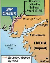
Sir Creek {local name Baan Ganga} is a 96 kilometres long estuary in the marshes of the Rann of Katch where Arabian Sea joins the land mass. It’s basically a fluctuating tidal channel, not truly a flowing creek. It currently lies on the border of India’s Gujarat and Pakistan’s Sindh province. In marshy areas like the Rann, landmasses emerge and slip back into water. The joint survey held by India and Pakistan held in 2007 claimed Sir Creek had shifted nearly 1.5 km eastwards.
At the time of partition, boundary here was not demarcated and since then, Pakistan has claimed the entire creek.
Background
Out of the total 7417 kilometres of total coastline of India shared by nine states, Gujarat with 1663 kilometres is the state with largest coastline. The Gujarat coast is characterised by two major gulfs viz. Gulf of Katch and Gulf of Cambay. A part of Pakistan’s coastline is adjacent to that of the India’s Gujarat coast. But there are no bilateral agreements defining the maritime boundaries. Not only these boundaries are unsettled but also there is absence of clear fishing laws. The Maritime Zones Acts of both India and Pakistan are almost twins but none of them is said to be corresponding to the United Nations Convention of Law of Sea (UNCLOS).
The marshlands of Sir Creek became first disputed between the Rao of princely state of Katch and the Chief Commissioner of Sindh Province of British India due to different perceptions of the boundaries. The case was taken up by then Government of Bombay, which conducted a survey and mandated its verdict in 1914. This verdict has two contradictory paragraphs, which make the India and Pakistan contenders on the same issue.
- Paragraph 9 of this verdict says that the boundary between Kutch and Sindh lies ‘to the east of the Creek,’ which effectively implied that the creek belonged to Sindh and, therefore, to Pakistan.
- On the other hand, Paragraph 10 says Sir Creek is navigable most of the year and quotes the chief commissioner of Sindh to buttress the point.
According to international law, a boundary can only be fixed in the middle of the navigable channel, which meant that it has be divided between Sindh and Kutch, and thereby India and Pakistan. India has used this para to consistently argue that the boundary needs to be fixed in the middle of the creek.
Sir Creek Issue: A Cartographic Dilemma
The map of the region was chalked out in 1925 and in this map, a ‘green riband was shown to the east of the Creek’. Pakistan says that this ‘Green Line’ is the marked boundary between Sindh and Kutch, and argued that the Creek belonged to Sindh.
India countered, saying the depiction was part of ‘normal cartographic practice’ and should not be used to make any territorial claims. Thus, this dispute is a classic example of cartographic dilemma. Till 1954, the borders around Sir Creek were virtually open and there was a free movement of people and material from both sides. After 1954, the countries started rigid stances on borders and a controversy evolved around Sir Creek. Till 1968, India and Pakistan were competing each other to provide historical evidence that it belonged to them.
 Importance of Sir Creek
The strategic or military importance of Sir Creek is little. The core importance of the Sir Creek is because of the fishing resources. Sir Creek is considered to be one of the largest Fishing grounds in Asia. Further, immense potential economic benefits as the marshlands are estimated to be rich in hydrocarbons and shale gas, is another importance of Sir Creek.
Stands of India and Pakistan
In arguments made at the UN tribunal, India claimed that Kutch was a well-defined entity and the Raos of Kutch paid tribute to imperial powers, first Mughals, then British. Pakistan uses different colonial sources to say the Kutch never had an existence of its own, that the rulers of Sindh had invaded and occupied parts of the Rann in the 18th century, and that the whole breadth of the Rann was the boundary between Kutch and Sindh.
In spite of this historical nebulosity, the tribunal supported India’s claim to 90 per cent of the Rann, fixed the land border up to a point called the Western Terminus, but left the westernmost part of the border fluid. This includes the stretch of water now under dispute.
Current Position
The dispute between India and Pakistan is on 3 issues:
- The actual demarcation “from the mouth of Sir Creek to the top of Sir Creek”
- The actual demarcation “from the top of Sir Creek eastward to a point on the line designated on the Western Terminus”.
- Demarcation of maritime boundary between India and Pakistan in Arabian Sea.
India and have held the talks in earlier {latest 2012} on Sir Creek Dispute. Neither has changed its claims on the creek since then. In 2007, the two sides had exchanged maps that matched. But the process was derailed by the Mumbai attacks.
Road ahead
If Sir Creek is to be treated as a water border, it must be divided according to international laws that govern such boundaries. Further, if India gives up control of the Creek, there is no guarantee that Pakistan would not claim any new territory in the sector, particularly when some oil or gas resource is discovered. Thus, despite being a small issue, it does not solve due to trust deficit.


 Latest News
 General Studies