- Home
- Prelims
- Mains
- Current Affairs
- Study Materials
- Test Series
 EDITORIALS & ARTICLES
Temperature Inversion
- Under normal conditions, temperature usually decreases with increase in altitude in the troposphere at a rate of 1 degree for every 165 metres. This is called normal lapse rate.
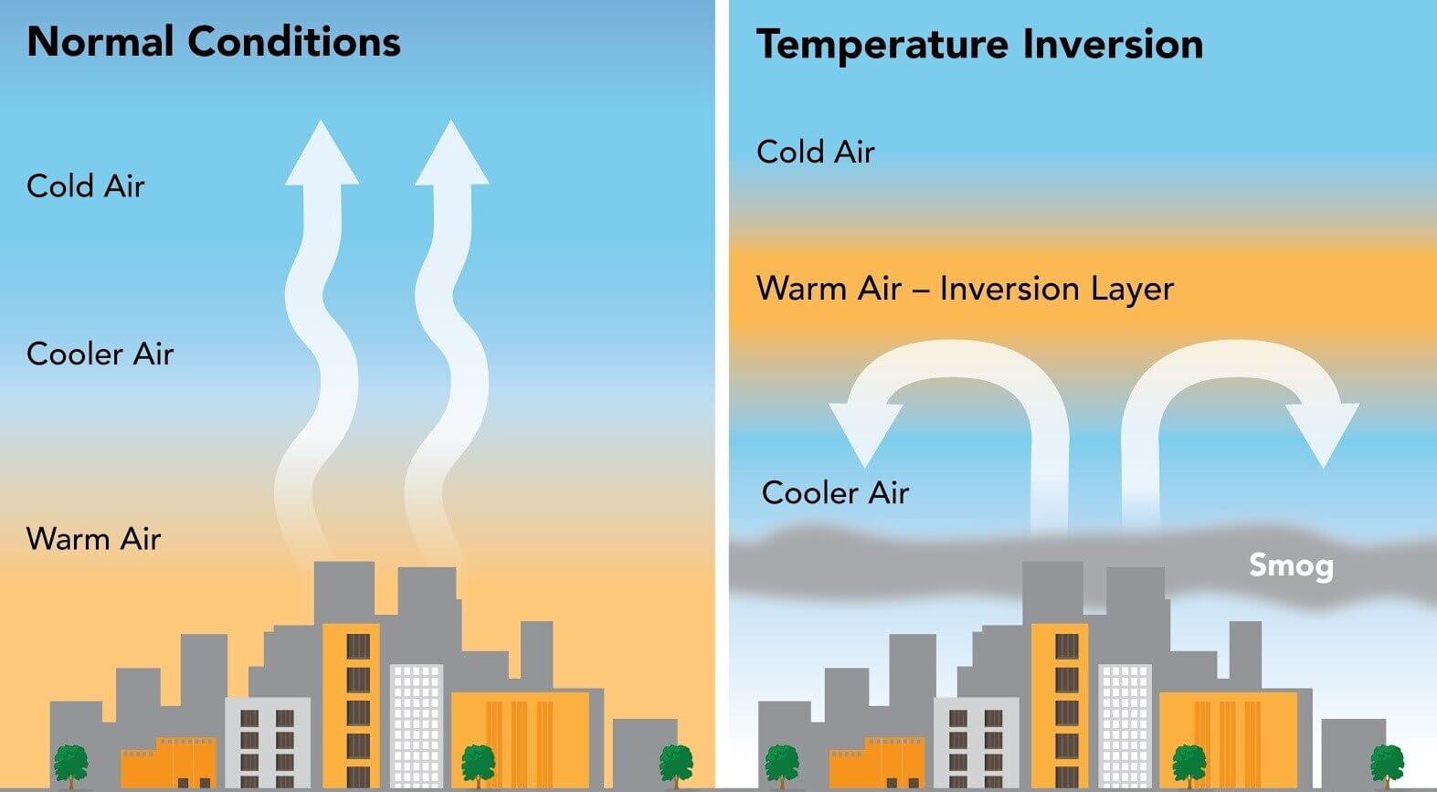
- But on some occasions, the situations get reversed and temperature starts increasing with height rather than decreasing. This is called temperature inversion.
- Temperature inversion:It is a reversal of the normal behavior of temperature in the troposphere. Under this meteorological phenomenon a layer of warm air lies over the cold air layer. It is caused in stac atmospheric conditions while some times, it occurs due to horizontal or vertical movement of air.
- Temperature inversion is usually of short duration but quite common nonetheless.
Favourable Conditions for Temperature Inversion
- Long winter nights:Loss of heat by terrestrial radiation from the ground surface during night may exceed the amount of incoming solar radiation.
- Cloudless and clear sky: Loss of heat through terrestrial radiation proceeds more rapidly without any obstruction.
- Dry air near the ground surface:It limits the absorption of the radiated heat from the Earth’s surface.
- Slow movement of air:It results in no transfer or mixing of heat in the lower layers of the atmosphere.
- Snow covered ground surface:It results in maximum loss of heat through reflection of incoming solar radiation.
Types of Temperature Inversion
- Temperature inversion occurs in several conditions ranging from ground surface to great heights. Thus there are several kinds of temperature inversions.
- The following are classified on the basis of relative heights from the earth’s surface at which it occurs and the type of air circulation:
- Non-Advectional
- Radiation Inversion (Surface Temperature Inversion)
- Surface temperature inversion develops when air is cooled by contact with a colder surface until it becomes cooler than the overlying atmosphere; this occurs most often on clear nights, when the ground cools off rapidly by radiation. If the temperature of surface air drops below its dew point, fog may result.
- It is very common in the higher latitudes. In lower and middle latitudes, it occurs during cold nights and gets destroyed during day time.
- Radiation Inversion (Surface Temperature Inversion)
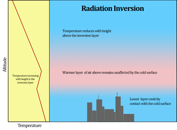 Ground or surface inversion, also called as radiation inversion, occurs near the earth''s surface due to radiation mechanism. This is also called as non-advectional inversion because it occurs in stable atmospheric condition characterized by almost no movement of horizontal or vertical air.
-
- Subsidence Inversion (Upper Surface Temperature Inversion)
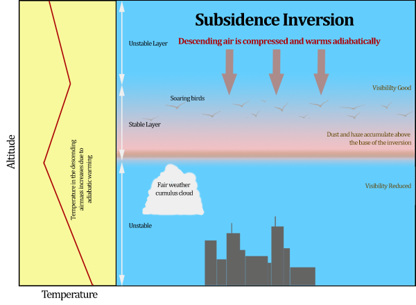
- When a widespread layer of air descends, it is compressed and heated by the resulting increase in atmospheric pressure, and as a result the lapse rate of temperature is reduced.
- The air at higher altitudes becomes warmer than at lower altitudes, producing a temperature inversion. This type of temperature inversion is called subsidence inversion.
- It is very common over the northern continents in winter (dry atmosphere) and over the subtropical oceans; these regions generally have subsiding air because they are located under large high-pressure centers.
- It is also called upper surface temperature inversion because it takes place in the upper parts of the atmosphere.
- Subsidence Inversion (Upper Surface Temperature Inversion)
-
- Advectional
Advection Inversions: They develop when there is a horizontal inflow of cold air into an area. This is common to cool maritime air blowing into a coastal locale. Advection inversions are usually short-lived (typically overnight) and shallow. They can happen at any time of year, depending on the location of the relatively cold surface and the direction of the wind.
-
-
- Valley inversion in intermontane valley
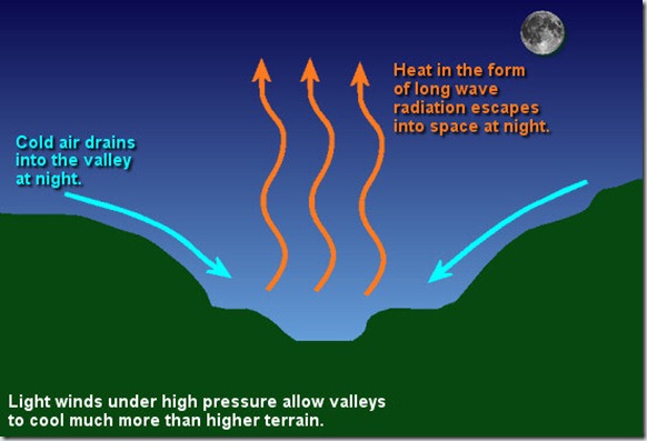
- In high mountains or deep valleys, sometimes, the temperature of the lower layers of air increases instead of decreasing with elevation along a sloping surface.
- Here, the surface radiates heat back to space rapidly and cools down at a faster rate than the upper layers. As a result the lower cold layers get condensed and become heavy.
- The sloping surface underneath makes them move towards the bottom where the cold layer settles down as a zone of low temperature while the upper layers are relatively warmer.
- This condition, opposite to normal vertical distribution of temperature, is known as Temperature Inversion.
- Valley inversion in intermontane valley
-
-
-
- Frontal or Cyclonic inversion
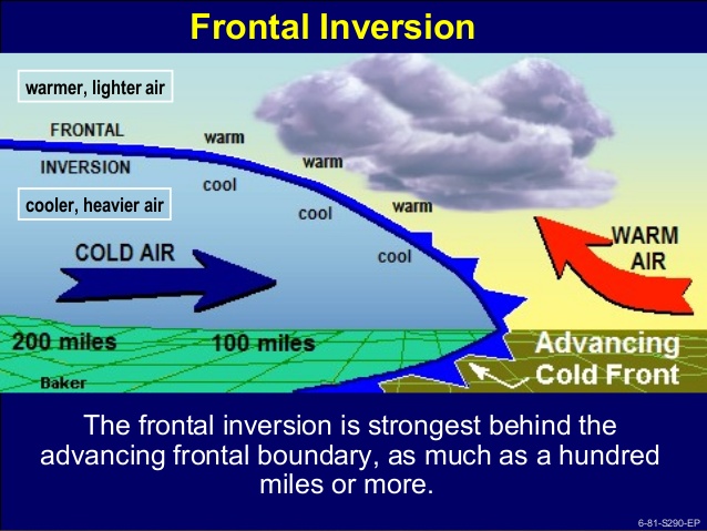
- When the warm and cold fronts meet, then the warm front rises up and being heavier the cold front sinks down. It results in formation of Frontal Inversion.
- It has considerable slope, whereas other inversions are nearly horizontal. It often takes place in the temperate zone and causes cyclonic conditions which result in the precipitation in different forms.
- A frontal inversion is unstable and is destroyed as the weather changes.
- Frontal or Cyclonic inversion
-
 Effect
- Temperature inversion determines the precipitation, forms of clouds, and also causes frost due to condensation of warm air due to its cooling.
- Dust particles hanging in the air:Due to inversion of temperature, air pollutants such as dust particles and smoke do not disperse on the surface.
- Stops the movement of air:It causes the stability of the atmosphere that stops the downward and upward movement of air.
- Less rainfall:Convection clouds can not move high upwards so there is less rainfall and no showers. So, it causes a problem for agricultural productivity.
- Lower visibility:Fog is formed due to the situation of warm air above and cold air below, and hence visibility is reduced which causes disturbance in transportation.
- Thunderstorms and tornadoes:Intense thunderstorms and tornadoes are also associated with inversion of temperature because of the intense energy that is released after an inversion blocks an area’s normal convention patterns.
- Diurnal variations in temperature tend to be very small.
Urban Heat Island (UHI) and Temperature inversion
Urban Heat Island (UHI) and Temperature inversion are two distinct atmospheric phenomena, but they can interact in ways that amplify environmental and health impacts—especially in cities.
Urban Heat Island Effect occurs when urban areas become significantly warmer than surrounding rural regions due to human activities. Concrete, asphalt, and buildings absorb and retain heat, while vegetation—which cools the air—is often sparse. This leads to elevated temperatures, especially at night, and creates a dome of warm air over the city. Temperature Inversion, on the other hand, happens when a layer of cooler air g
- Amplified Pollution: UHI can intensify temperature inversions by warming the surface air, making the temperature difference between the ground and the upper layer more pronounced. This strengthens the inversion layer and traps pollutants like smog, dust, and vehicle emissions.
- Health Risks: The combination of UHI and inversion can lead to poor air quality, increasing respiratory problems, especially for vulnerable populations.
- Reduced Cooling: Inversions can limit the natural cooling that might otherwise occur at night, making urban areas even hotter and more uncomfortable.
In short, when these two phenomena overlap, they can create a feedback loop that worsens air quality and urban discomfort. It's a reminder of how urban planning and environmental management need to work hand-in-hand.
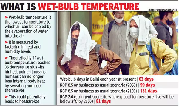
35°C threshold
Wet-bulb temperature combines heat and humidity to measure the human body’s cooling ability. It reflects how effectively sweat evaporates. When the wet-bulb temperature equals skin temperature, sweat evaporation ceases. This prevents the body from cooling down, leading to heat stress. The 35°C threshold was proposed by scientists Steven C. Sherwood and Matthew Huber in 2010. They suggested that exposure beyond this limit for extended periods could induce heat stroke within six hours. However, recent studies indicate that this threshold may be an overestimation.
- Recent Findings on Heat Stress - A 2023 study from the Center for Healthy Aging at Pennsylvania State University examined young subjects in warm environments of 40°C and 50% humidity. They found that core body temperatures began to rise after six hours, even below conventional heat exhaustion levels. This indicates that the survival limit may be lower than previously thought.
- Global South Conditions and Data Gaps - Currently, there is no sufficient data on prolonged heat exposure for vulnerable populations in the Global South. Most studies have focused on Caucasian populations and athletes. This gap in understanding may lead to inadequate responses to heat stress in low-income communities.
- Personalised Heat Exposure Index - Researchers are currently developing a personalised heat exposure index. This index aims to measure continuous heat exposure and physiological responses over time. Such data could help identify comfort limits in high-heat environments.
- Physiological Responses to Heat - The accepted 35°C limit is theoretical. If skin temperature matches the wet-bulb temperature, the body cannot lose heat efficiently. This can lead to dangerous body temperature increases. Additionally, heatwaves can cause severe health issues, including heart attacks and kidney injuries, even when core body temperatures remain stable.
- Broader Implications for Human Health - High temperatures can impact work productivity and overall quality of life. For instance, a street vendor noted that vegetables spoil at 40-42°C, affecting her livelihood.
- Future Projections and Regional Risks - The Pennsylvania State study warned that regions like the Middle East and the Indus River Valley may face extreme heat conditions with just 1.5°C of warming. These conditions could exceed historical human experience and current heat mitigation strategies.
- Acclimatisation and Complacency - Balsari cautioned against complacency regarding acclimatisation. While South Asians may adapt to heat, there is a limit to physiological adaptability. The COVID-19 pandemic illustrated that assumptions about immunity can be misleading, denoting the need for cautious approaches to heat stress.
|
Wet Bulb Temperature
Dew Point and Dry Bulb Temperatures
|


 Latest News
 General Studies