- Home
- Prelims
- Mains
- Current Affairs
- Study Materials
- Test Series
Earth Satellite Orbits
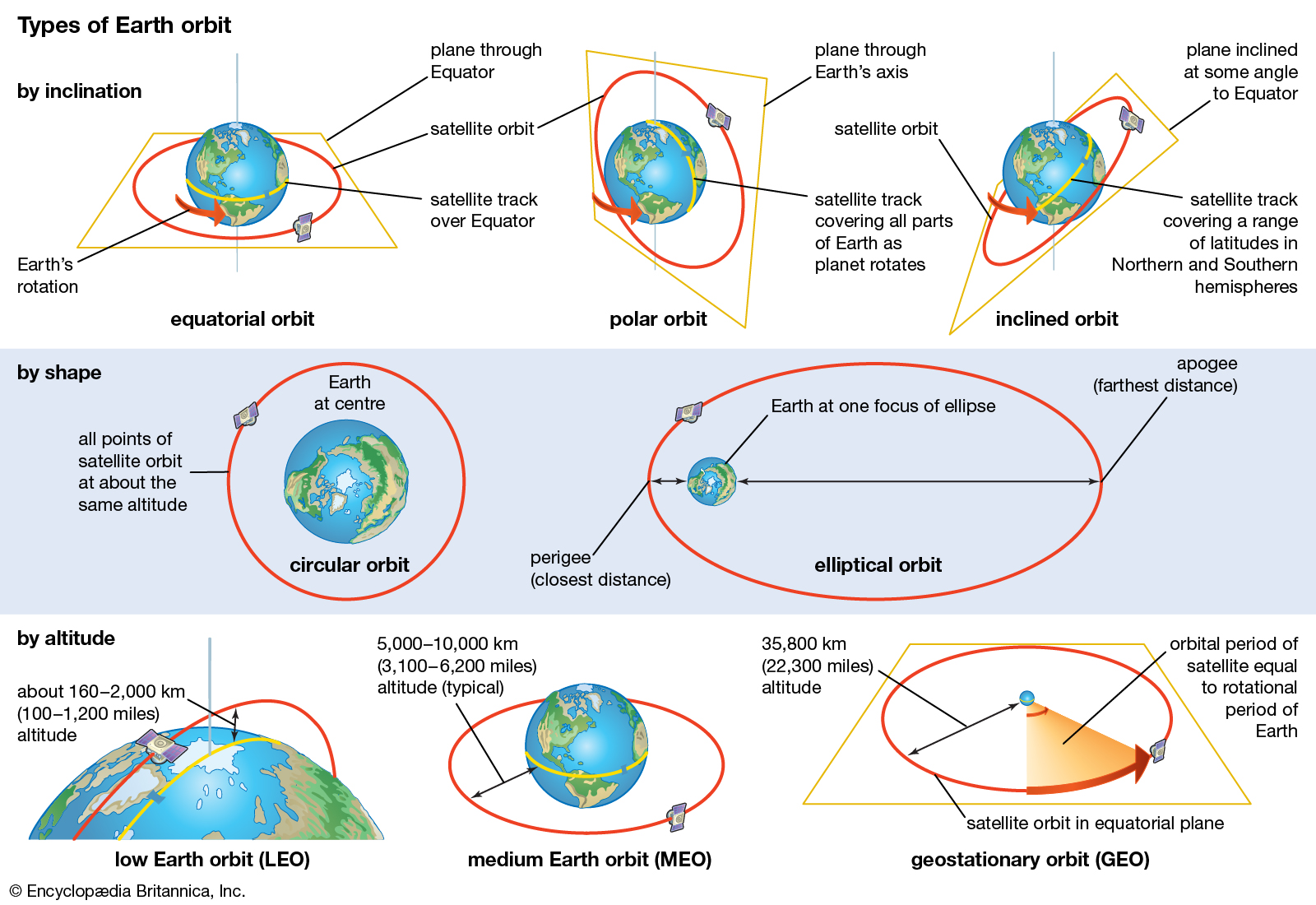
An orbit is a curved, regular, and repeating path that an object in space, such as a star, planet, moon, or spacecraft, takes around another one. An object, natural or artificial, in an orbit is called a satellite. Artificial satellites are placed in different orbits based on their utility and objectives. Orbits can be classified on the basis of altitude and functionality.
High Earth Orbit, Medium Earth Orbit, and Low Earth Orbit are the types of orbits based on altitude, and geostationary orbit, polar orbit, sun-synchronous orbit, etc. are the types of orbits based on their objectives.
Factors Influencing Functional Aspects of Satellites in an Orbit
Functional aspects of the satellite are achieved through a combination of factors. These factors essentially govern the movement of the various types of satellites and their associated aspects. These factors are:
- Altitudes: The height or altitude of the orbit from the surface of the Earth affects the speed of satellites. The speed of a satellite with respect to earth is inversely proportional to its altitude.
- Thus, the speed of a satellite placed in Low Earth Orbit will be greater than that of a satellite placed in a High Earth Orbit, due to the higher gravitational force of the Earth acting on the satellite.
- For example, NASA’s Aqua satellite requires about 99 minutes to orbit Earth at about 705 kilometers up (Low Earth Orbit), while a weather satellite about 36,000 kilometers from Earth’s surface takes 23 hours, 56 minutes, and 4 seconds to complete an orbit.
- Eccentricity (e):The eccentricity of an orbit indicates the deviation of the orbit from a perfect circle. It governs the shape of an orbit.
- A circular orbit has zero eccentricity, while a highly eccentric orbit is near to 1 (but always less).
- For example, the Molniya orbit has eccentricity (0.722) to maximize viewing time over high latitudes.
- Orbital inclination: It is the angle between the plane of an orbit and the equator.
- An orbital inclination of 0°is directly above the equator, and 90°crosses right above the pole.
- Polar satellites used for Earth observation and scientific research are inclined nearly 90 degrees to the Earth.
- Orbital period: The time taken by a satellite to complete one revolution in its orbit around the Earth is called an orbital period.
- It varies from around 100 minutes for a near-polar Earth-observing satellite to 24 hours for a geostationary satellite.
- Rotational direction of the satellites:
- Retrograde motion: When the direction of orbital or rotational motion of a satellite is opposite to the rotation of its central object (for example, Earth), it is called retrograde motion.
- Prograde motion: When the orbital or rotational motion of an object is in the same direction as its central object, it is called prograde motion.

Types of Orbit based on Altitude
There are three types of orbits based on altitudes - High Earth Orbit, Medium Earth Orbit, and Low Earth Orbit. The speed of a satellite depends upon the height of the orbit from the Earth’s surface.
High Earth Orbit (HEO)
HEO lies at and beyond 35,786 kilometers from Earth’s surface. It is a sort of “sweet spot” in which satellite orbit matches the rotation of the Earth.
- Application: A satellite in this orbit seems to stay in place over a single longitude, although it may drift north to south. This special, high Earth orbit is known as geosynchronous orbit.
- Examples: GSAT series of India''s indigenously developed communications satellites, used for digital audio, data, and video broadcasting.
Medium Earth Orbit (MEO)
MEO lies between 2,000 km to 35780 km from the surface of the Earth. Two Medium Earth Orbits are the semi-synchronous orbit and the Molniya orbit. MEO satellites have orbital periods ranging from 2 to 24 hours. Satellites in MEO have an orbital period between 2 to 24 hours.
- Application: This is the orbit used by the Global Positioning System (GPS) satellites such as GLONASS (Altitude of 19,100 kilometers) and Galileo (Altitude of 23,222 kilometers).
Low Earth Orbit (LEO)
LEO has an altitude between 160 km to 1000 km above the Earth’s surface. Satellites in this orbit take approximately 88 - 127 minutes to circle Earth.
- Applications: This orbit is commonly used for satellite imaging, Earth observation, etc., but communicational satellites (in constellations) are also placed in this orbit.
- The International Space Station (ISS) is placed in this orbit, traveling about 16 times around Earth per day.
- A Constellation of 36 communication satellites of OneWeb (Satellite communications company) has been placed in LEO by ISRO.
- Earth Observatory satellite- RISAT-2B (Radar Imaging Earth observation satellite) of ISRO was launched in LEO for the application of the Disaster Management System.
Types of Orbit based on Functionality
Based on the various combinations of the above-mentioned factors (Altitude, Eccentricity, Inclination), the most common functional orbits are Geostationary orbit, Polar orbit, Sun-synchronous orbit, Molniya orbit, etc.

Geosynchronous Orbit and Geostationary Orbit
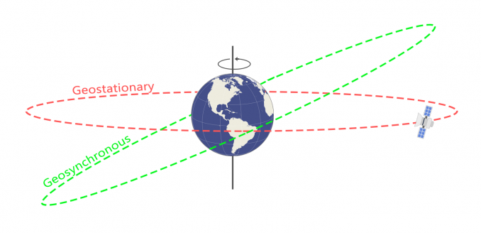
A geosynchronous orbit (GEO) is a prograde (in the direction of Earth’s rotation), low inclination, High Earth orbit around Earth. A spacecraft in this orbit appears at a constant longitude above the Earth. The geosynchronous orbit is also called the Clarke orbit, as it was first popularised by the science fiction author Arthur C. Clarke.
- Geostationary Orbit: Geostationary orbit is a particular case of the geosynchronous orbit, with zero eccentricity and almost zero inclination (latitude), so that the spacecraft in this orbit appears stationary above a point on the Earth.
- Such maneuvering in orbit is called station keeping.
- Altitude of the Geostationary Orbit: The Geostationary orbit (or Geosynchronous Orbit) lies exactly 42,164 kilometers from the Earth''s center (35,786 kilometers from Earth’s surface).
- At this point, the orbital period of the satellite exactly matches the rotational period of the Earth (taking 23 hours 56 minutes, and 4 seconds) as it travels at geosynchronous speed (exactly the same speed as the Earth).
- Applications: Weather monitoring satellites must be placed in GEO as they need constant observation of particular areas on the surface of the Earth. Some communication and navigational satellites are also placed in this orbit.
- Meteorological satellites: INSAT series (ISRO), MeteoSAT (Europe), Geostationary Operational Environmental Satellite (NASA), Geostationary Meteorological Satellite (JAXA), etc.
- Communication satellites: INSAT and GSAT series of India
- Three of the seven NavIC (Indian navigational satellites) satellites are placed in geostationary orbit whereas; four are placed in inclined geosynchronous orbit.
- Many high Earth-orbiting satellites monitor solar activity and track magnetic and radiation levels in space around them.
Polar Orbit
Polar orbit is a Low Earth orbit where satellites travel past Earth from north to south.
- Altitudes: The altitudes of the polar orbits range between 200 to 1000 km. Lower altitudes enable satellites to faster revolution. In polar orbits, satellites can complete 15 to 16 revolutions around the Earth.
- Inclination: Inclination of the polar orbits around 90 degrees, with a deviation ranging from 20 to 30 degrees.
- Eccentricity: Polar orbit follows a circular shape; hence, eccentricity is close to zero, hence nearly circular shape.
- Applications: Polar orbits have specific characteristics that make them useful for various applications, particularly for Earth observation (remote sensing) and scientific research.
- Remote sensing: Such applications generally use nearly polar orbits to attain global coverage. Example is Cartosat-3.
- Resource management: Applications such as monitoring crops, forests, and even global security, as done by the Cartosat series of ISRO.
Sun-synchronous Orbit
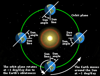
It is a particular type of Polar Orbit, travelling over the polar regions. A typical Sun-synchronous satellite completes 14 orbits a day, and each successive orbit is shifted over the Earth’s surface by around 2875 km at the equator.
- Features: Satellites in this orbit are synchronous with the Sun, i.e. they are always in the ‘fixed’ position relative to the Sun.
- Hence, in this orbit, the satellite always visits the same spot at the same local time. For example, passing Paris every day at exactly the same time in the afternoon.
- It has constant sun illumination through inclination and altitude.
- Altitude: A satellite in a Sun-synchronous orbit would often be at an altitude of between 600 to 800 km.
- Applications: Sun-synchronous can be used for the following purposes:
- To investigate climate change and weather patterns, it enabled scientists to compare images from the same season over several years and deliver consistent information required to study phenomena like climate change.
- To help predict atmospheric disturbance and extreme events like severe cyclonic storms, etc. For example, SARAL (Satellite with ARGOS and ALTIKA) is placed in the Sun-synchronous orbit for oceanographic studies.
- Monitoring emergencies like forest fires or flood situations.
- To accumulate data on long-term problematic events like deforestation or rising sea levels.
- Remote sensing applications in the management of resources
Semi-synchronous orbit
Semi-synchronous orbit lies in the medium Earth orbit between LEO and GEO.
- Altitude: It is 20,200 kilometers above the surface (about 26,560 km from the center of the Earth). A satellite in this orbit takes around 12 hours to complete one cycle.
- Eccentricity: The semi-synchronous orbit has a low eccentricity (near-circular orbit).
- Application:
- Global Positioning System (GPS) and GLONASS satellites use this orbit.

Molniya Orbit
- Molniya Orbit combines high inclination (63.4°) with high eccentricity (0.722) for better observation and covering larger swaths.
- It is developed as a high-latitude (for example, polar regions) communication alternative to geostationary orbits.
- The high-altitude portion of the orbit repeats over the same location every day and night.
- Applications of Molniya orbit:
- High latitude observation: Satellites in this orbit have better capability to observe events and associated phenomena in polar regions like the impact of climate change on polar regions.
- Meteorological observation of middle and high latitudes: Meteorological instruments placed on a satellite in a Molniya orbit improve the temporal frequency of observation of high-latitude phenomena such as polar lows.
- Communications in the far north or south: Russian communications satellites and the Sirius radio satellites currently use this type of orbit. It is often used by navigation satellites, like the European Galileo system.
Transfer Orbits
Transfer orbits are intermediate orbits used to shift a satellite from one orbit to another. Satellites are launched from Earth and placed on a transfer orbit before finally being placed in the destination orbit in subsequent stages with the help of their propulsion systems.
- Polar Transfer Orbit (PTO): It is an orbit at an altitude of about 100 km below the Polar or Low Earth Orbit. Remote Sensing satellites are launched into this orbit first, and then, using their own propulsion systems, they lift themselves to the desired orbit.
- Geostationary Transfer Orbit (GTO): This orbit is located at a height of about 200 km below the geostationary orbit. GSS is first launched in GTO and then lifts itself using its own propulsion system to the desired orbit.
Hence, this allows a satellite to reach smoothly in two steps more efficiently without actually needing the launch vehicle to go all the way to this altitude. It is like a stepping stone for reaching a high-altitude orbit like GEO.
- In transfer orbits, the payload uses engines to go from an orbit of one eccentricity, a measure of how circular (round) or elliptical (squashed) an orbit is, to another, which puts it on track to higher or lower orbits.
Lagrange Points (L-points)/Halo Orbit
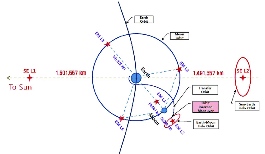
Lagrange points are five special points of enhanced regions of attraction and repulsion between the Sun and the Earth system. It is named after Joseph-Louis Lagrange, an Italian-French mathematician.
- L1: Locating between the Earth and the Sun, it gives satellites a constant view of the Sun.
- Aditya-L1 Mission: It is the first space-based observatory-class Indian solar mission to study the Sun. It is placed in a halo orbit around the Lagrangian point (L1).
- L2: It is located behind the Earth. Earth is between the L2 and Sun. It is a significant place to observe the larger Universe. The James Webb Space Telescope is placed at L2.
- Other points (L3, L4, L5): L3 is on the other side of the Sun, opposite the Earth. L4 and L5 fall on the apex of two equilateral triangles.


 Latest News
 General Studies