- Home
- Prelims
- Mains
- Current Affairs
- Study Materials
- Test Series
Hurricane Milton the ‘storm of the century’
In the first week of Oct 2024, Hurricane Milton made landfall near Siesta Key, Florida, causing serious damage with heavy rain, flooding, tornadoes, and strong winds. Although the storm was unusual, scientists warned about such events due to climate change.
Impact of Hurricane Milton
- Casualties and Damage: The storm resulted in at least 12 deaths, mainly in eastern Florida. It destroyed homes, disrupted power for over 3 million customers, and caused flooding on barrier islands.
- Extreme Weather Events: Milton brought over 45.72 cm (18 inches) of rain to St. Petersburg, a level of rainfall that typically happens once in 1,000 years.
- Current Status: The National Hurricane Center reported that Milton has weakened and moved into the North Atlantic Ocean.

Characteristics of Hurricane Milton
- Rapid Intensification:
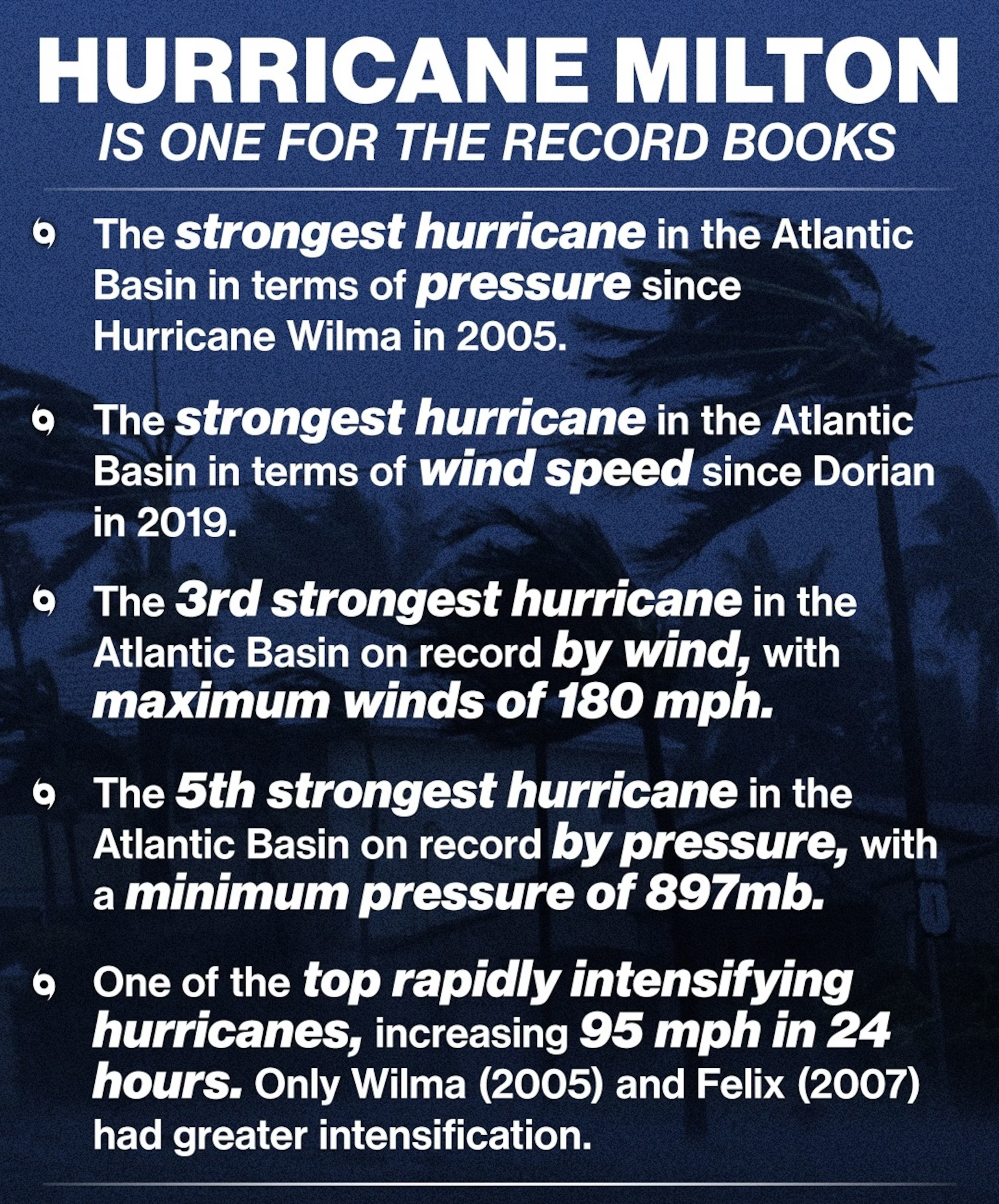
- Storm Classification: Milton quickly changed from a Category 1 hurricane (winds of 119 to 153 km/h) to a Category 5 hurricane (winds of 252 km/h or higher) in just 12 hours between October 6 and October 7.
- Wind Speed Increase: By the afternoon of October 7, Milton reached sustained winds of 285 km/h, making it one of the strongest hurricanes recorded in the Atlantic.
- Definition of Rapid Intensification: A hurricane is considered to rapidly intensify if its winds increase by at least 56 km/h. Milton’s winds increased by over 145 km/h in just one day.
- Uncommon Formation and Path:
- Origin: Milton formed in the Gulf of Mexico and moved eastward to hit Florida''s western coast. Atmospheric scientist Jonathan Lin noted that few hurricanes have taken this path while reaching Category 3 or higher.
Factors Contributing to Milton''s Unusual Intensity
- High Sea-Surface Temperatures:
- Temperature Insights: On the day Milton became a Category 5 storm, sea-surface temperatures in the Gulf of Mexico were nearly 31°C, well above the 26°C needed for hurricanes to form.
- Role of Ocean Heat: Warmer ocean water evaporates more easily, fueling storms. Rising temperatures are linked to climate change, with global sea surface temperatures increasing by about 0.9°C since 1850.
- High Atmospheric Humidity:
- Moisture Retention: The atmosphere can hold 7% more moisture for every 1°C rise in temperature. More moisture makes storms stronger and leads to heavier rainfall.
- Lack of Wind Shear:
- Wind Shear Dynamics: Wind shear refers to changes in wind speed and direction that can disrupt storms. In Milton’s case, low wind shear allowed the hurricane to stay strong.
Context of Recent Hurricanes
- Rising Instances of Rapid Intensification:
- Recent Trends: Milton’s rapid intensification is not a one-time event; other recent hurricanes, like Otis (Mexico) and Idalia (2023), have shown similar quick changes in strength.
- Climate Change Connections:
- Research Findings: A 2017 study indicated that global warming could lead to more frequent rapid intensification of hurricanes as the planet warms.
- Future Projections: A recent report warned of a new phase in the climate crisis, predicting more extreme weather events in the coming years.
|
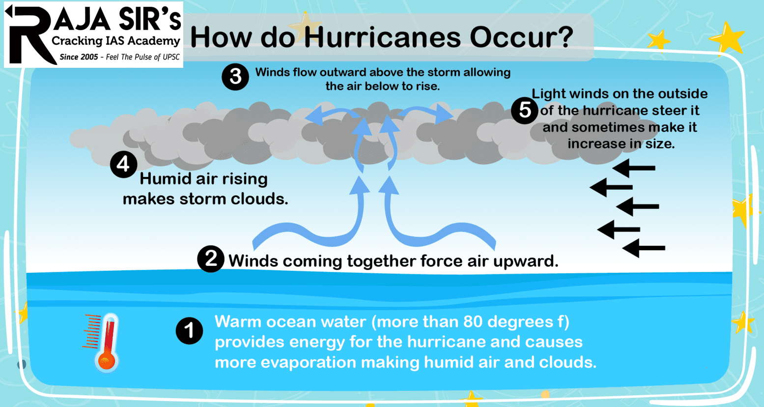
What are Hurricanes? Hurricanes are intense tropical cyclones characterized by a low-pressure center and thunderstorms that produce strong winds and heavy rain.
Formation of a Hurricane: Hurricanes form under specific conditions, primarily over warm ocean waters.
Process:
Once formed, hurricanes can intensify or weaken depending on environmental conditions, such as water temperature, wind shear, and land interactions. The Saffir-Simpson Hurricane Wind Scale: Hurricanes are classified based on their maximum sustained wind speeds using the Saffir-Simpson Hurricane Wind Scale. This scale ranges from Category 1 to Category 5, with Category 5 representing the most powerful hurricanes.
|


 Latest News

 General Studies