- Home
- Prelims
- Mains
- Current Affairs
- Study Materials
- Test Series
Red Sea crisis
The Ministry of Commerce and Industry (MoCI) reports that Indian exports to Europe, especially low-value products such as agriculture and textiles, are facing disruptions due to escalating tensions in the Red Sea and ongoing drought issues at the Panama Canal. In response, an inter-ministerial meeting chaired by the Union Commerce Secretary, involving key ministries like External Affairs, Defence, Shipping, and the Department of Financial Services (DFS) under the Ministry of Finance, addressed the concerns about potential impacts on global trade.
The rerouting of shipments through the Cape of Good Hope, in response to heightened security concerns in the Red Sea and Panama Canal, has led to delayed sailings and a significant increase in freight rates to Europe.
Red Sea
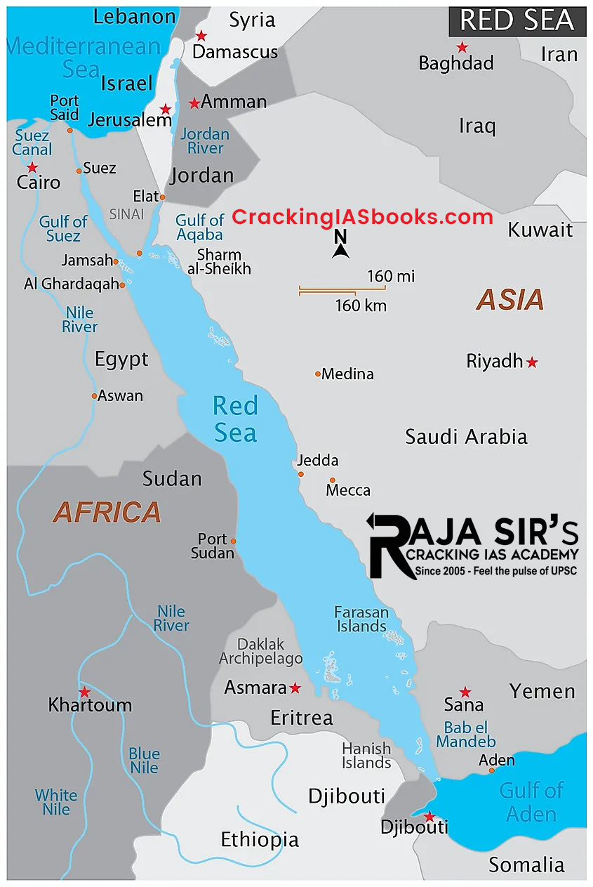
- The Red Sea is a semi-enclosed tropical basin, bounded by northeastern Africa, to the west, and the Arabian peninsula, to the east.
- The elongated and narrow-shaped basin extends between theMediterranean Sea, to the northwest, and the Indian Ocean, to the southeast.
- At the northern end, it separates into theGulf of Aqaba and the Gulf of Suez, which is connected to the Mediterranean Sea via the Suez Canal.
- At the southern end, it is connected to the Gulf of Aden, and the outer Indian Ocean, via the Strait of Bab-el-Mandeb.
- It is surrounded by desert or semi-desert areas, with no major freshwater inflow.

Issues in the Red Sea and Panama Canal Presently
- Red Sea:
- Issue:Chemical tanker MV Chem Pluto was struck by a drone attack, approximately 200 nautical miles off Gujarat''s coast.
- MV Chem Pluto is a Liberia-flagged, Japanese-owned, and Netherlands-operated chemical tanker. It had started its journey carrying crude from Al Jubail, Saudi Arabia and was expected to arrive in New Mangalore, India.
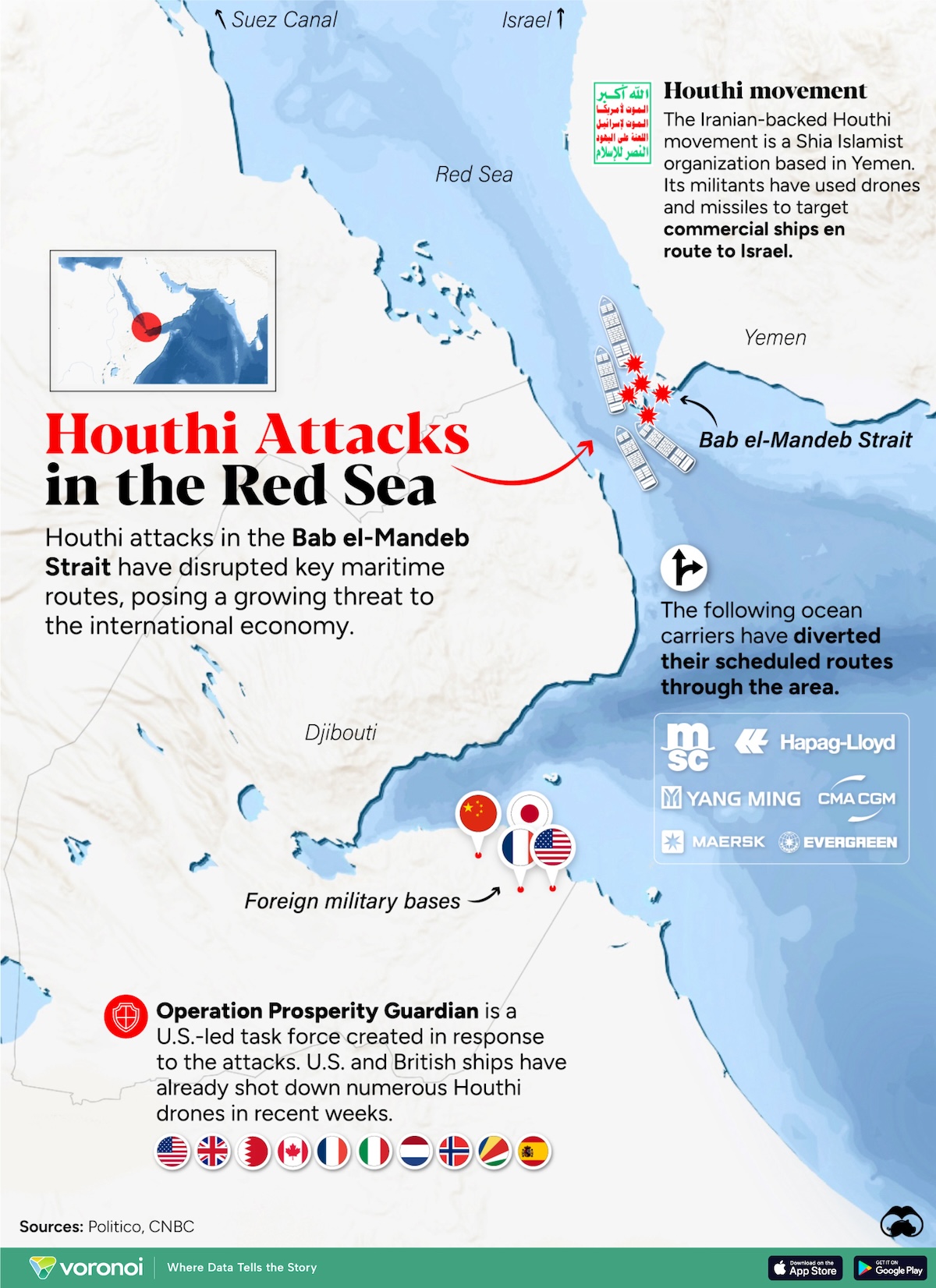
- Allegedly Involved Entity:It is believed to have been carried out by Houthi rebels based in Yemen, citing protest against Israel’s actions in Gaza.
- Houthi rebels are also engaged in a decade-long civil conflict with Yemen''s government.
- Panama Canal:
- Issue:Due to drought conditions, shipping through the 51-mile stretch of the Panama Canal has decreased by over 50%.
- A naturally occurringEl Nino climate pattern associated with warmer-than-usual water in the central and eastern tropical Pacific Ocean is contributing to Panama''s drought.
- Infrastructural Lacunae: The Panama Canal''s operational challenges and the shift in trade focus to alternative routes like the Red Sea have raised various concerns that require prompt attention.
- Issues such as the need for dredging and reducing depth have emerged, posing obstacles for the navigation of large vessels. Immediate measures are essential to address these challenges.
- Both these routes are among the busiest in the world.
- Issue:Due to drought conditions, shipping through the 51-mile stretch of the Panama Canal has decreased by over 50%.
- Issue:Chemical tanker MV Chem Pluto was struck by a drone attack, approximately 200 nautical miles off Gujarat''s coast.
Impact on India Due to the Above Issues
- Impact on Agricultural Commodities:
- Concerns arise for exporters of key commodities like basmati and teadue to disruptions in this critical trade route.
- Disruption in the Red Sea route could increase Indian agricultural product prices by 10-20% as shipments reroute through the Cape of Good Hope.
- Impact on Oil and Petroleum Trade:
- Global oil and petroleum flows have declined due to major shipping companies avoiding the Red Sea. However, India''s oil imports from Russia remain unaffected.
- India''s reliance on Russian oil,perceived as Iran’s ally, has remained stable amid the conflict in the Red Sea.
- Costlier Export to US:
- The water scarcity issue in the Panama Canal and the ensuing drought are forcing ships voyaging from Asia to the US to choose the Suez Canal, resulting in an additional six days of travel compared to the Panama Canal route.
- Panama Canal as not a Feasible Option:
- While theBab-el-Mandeb Strait that leads to the Suez Canal in the Red Sea region connects Asia to Europe, the 100-year-old Panama Canal connects the Atlantic and Pacific Oceans and is not a very viable option for India.
- Global oil and petroleum flows have declined due to major shipping companies avoiding the Red Sea. However, India''s oil imports from Russia remain unaffected.
Factors Contributing to the Present Crisis

- Modern Weaponry Concerns:
- The Red Sea situation is becoming complex, impacting both stability and trade.
- The use of advanced weaponry raises questions about the effectiveness of joint defence efforts among nations, leading to concerns about trade disruption and claims of high interoperability.
- Adaptation of Piracy Techniques:
- Similar to past piracy challenges, delayed international responses have allowed rebels to adapt to modern technologies.
- This has led to tactics such as hijacking ships and using them as mother ships, expanding the ''High-Risk Area'' and affecting maritime tradethrough rerouting and increased insurance costs.
- State Support and Missile Proliferation:
- The involvement of Houthi rebels using drones and Anti-Ship Ballistic Missiles (ASBMS), along with potential state support from Iran and China, raises concerns about missile technology proliferation.
- The supply of ASBMS, directly or indirectly, is linked to China, adding complexity to the situation.
- Lacklustre Response to Operation Prosperity Guardian:
- The U.S.-launchedOperation Prosperity Guardian, intended to operate under the Combined Maritime Force, has seen a tepid response from allies and partners.
- NATOallies like France, Italy, and Spain operate independently, indicating doubts about the U.S.''s ability to drive international cooperative mechanisms.
- Saudi Arabia and UAE''s Non-Participation:
- Saudi Arabia''s absence from the operation, likely to avoid negative impacts on Yemen negotiationsand relations with Iran, reveals complexities.
- The UAE''s reluctance may stem from avoiding perceived support for Israel.
- India, despite being a full member, operates independently, possibly due to its relations with Iran.
- Global Division on Maritime Security:
- Operation Prosperity Guardian''s inability to function as a coalition highlights divisions among like-minded nations supporting freedom of navigation as mandated by United Nations Convention on the Law of Sea (UNCLOS).
- Even U.S. allies such as Japan and Australia are yet to join, emphasizing the lack of convergence on maritime security and rule-based world order.
Measures that India Adopt to Reduce Vulnerability to These Issues
- Joint Maritime Security Initiative: Propose a collaborative security framework with key Red Sea stakeholders (Egypt, Saudi Arabia, UAE, Yemen) involving intelligence sharing, coordinated patrols, and joint exercises.
- Deploy Advanced Surveillance Systems:Install integrated radar and drone surveillance systems along India''s western coastline to enhance early threat detection and response capabilities.
- Negotiate Preferential Access: Engage with Panama Canal authoritiesto explore preferential passage for Indian vessels or potential toll discounts for specific routes.
- Alternate Trade Routes Under Consideration:Recently, there has been renewed interest in the Ben Gurion Canal Project, a proposed 160-mile-long sea-level canal that would connect the Mediterranean Sea with the Gulf of Aqaba, bypassing the Suez Canal.
- Designation of Houthis as Global Terrorists: Starting mid-February, theS. will label the Houthis as a specially designated global terrorist group,potentially blocking their access to the global financial system.
- This move comes despite previous removal from the U.S. terror listing, with Saudi Arabia warning of the Houthi threat.India can join hands with like-minded countries to ward off such threats.
- Calibrated and Cooperative Approach:Houthi rebels exploit the division among nations and question the U.S.''s global dominance. Similar to piracy solutions, addressing the supply of weaponry becomes crucial.
- The situation in Yemen differs, and actions need to be calibrated to prevent a state-on-state confrontation and maintain stability.
- Avoiding Yemen as a Battleground:There is a need for an achievable end state by preventing the legitimization of the Houthis as a state actor, emphasizing the importance of avoiding turning Yemen into a battleground like Lebanon.
- Facilitating Export Credit:The MoCI, concerned about the hold on consignments due to high freight costs and surcharges, has instructed DFS to ensure a continuous credit flow to exporters.
- Maintaining Buffer Stocks:The Ministry of Chemicals and Fertilizers assured that tensions in the Red Sea region would not result in a fertilizer shortage in India.
- It stated that the country possesses abundant stocks to meet the upcoming kharif season''s requirements.
The escalating conflict involving Houthi rebels in Yemen and their attacks on merchant shipping in the Red Sea presents a multifaceted challenge. The use of advanced weaponry, including drones and anti-ship ballistic missiles, underscores the rebels'' capabilities and raises concerns about state support, particularly from Iran and possibly China. As the situation unfolds, a careful and calibrated approach is crucial to prevent further deterioration, emphasizing the urgency for a viable and achievable end state that avoids turning Yemen into a prolonged battleground.
|
Bab el-Mandeb strait
|


 Latest News
 General Studies